


Upgraded Kalgoorlie radar provides regional WA with Doppler images
02/12/2015
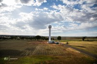
The Bureau of Meteorology’s Kalgoorlie weather watch radar has today (2 December) been upgraded to provide Doppler radar images for the first time in regional Western Australia.
Doppler imagery will help forecasters more accurately detect and monitor severe weather events such as thunderstorms, which are a regular weather feature in the Goldfields region from November to April.
Additionally, radar images are now scanned and available to the public every 6 minutes instead of every 10 minutes.
The Doppler images show wind speed and direction, a valuable addition to the rain images most commonly associated with weather radars.
The upgrade also includes a new improved rainfall service, which will provide a more comprehensive estimation of rainfall amounts in the Kalgoorlie area.
The new radar-based rainfall information is accessible via the Bureau’s radar viewer and provides the best possible mix of radar and rain gauge data. This service provides more information than is currently available from the rain gauge network alone. The community will now get a much better snapshot of where the heaviest rain has fallen.
The increased data frequency will help forecasters to more accurately detect and monitor severe weather events. Meteorologists and hydrologists combine radar information with satellite and surface observations, as well as numerical models, as a basis for developing weather forecasts and warnings.
The Kalgoorlie weather watch radar was installed in May 2014, replacing the previous ageing radar. It is strategically located in the national radar network to cover the Goldfields.
Kalgoorlie Radar Loop
