


Tropical Cyclone Tatiana forecast to remain off the Qld coast and weaken
12/02/2016
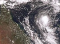
The Bureau of Meteorology is currently monitoring the development of Tropical Cyclone Tatiana located over 1000km northeast of Fraser Island in the Coral Sea.
Tropical Cyclone Tatiana intensified to a Category 2 system this morning, and is continuing to move in an east-southeasterly direction. Tatiana is expected to adopt a more south-southeasterly track later today (Friday), and gradually intensify before exiting the Brisbane Tropical Cyclone Warning Centre's region of responsibility this evening.
The system is located well off the east coast of Queensland, and forecast to move further away during the weekend, weakening into a low pressure system. While the cyclone does not pose an immediate threat to the Queensland coast, the system will continue to be monitored closely for future redevelopment.
Tropical Cyclone Tatiana is likely to bring increasing easterly swells to areas south of Sandy Cape, including the Sunshine Coast and the Gold Coast from late Sunday into early next week. Mariners and beachgoers should refer to the Bureau's marine forecasts.
The Bureau’s Tropical Cyclone Warning Centre in Brisbane will continue to monitor the situation closely, providing regular warning updates to local emergency services (QFES), and keeping the community informed through regular media and social media channels.
The Bureau is using Twitter to disseminate significant weather information for the community. Follow us @BOM_QLD. The Bureau's website remains the most up-to-date and comprehensive official source of information. This tropical cyclone season we’re using hashtags starting #Cyclone, e.g. #CycloneTatiana.
For the latest Tropical Cyclone Warning information go to www.bom.gov.au/cyclone
To view the satellite loop satview.bom.gov.au/
