


Our weak and short-lived La Nina comes to an end
13/03/2018
The La Niña that has been in place throughout the summer of 2017–18 has ended.
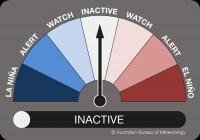
The Bureau of Meteorology today announced that El Niño–Southern Oscillation (ENSO) indicators have eased back to neutral levels over the past several weeks, which means the ENSO Outlook has shifted from La NIÑA to INACTIVE.
BOM's Manager of long-range forecasting, Dr Andrew Watkins, said current oceanic and atmospheric conditions make it clear that the La Niña is over.
"Sea surface temperatures in the tropical Pacific have warmed steadily since December and are now in the neutral range," Dr Watkins said.
"Waters beneath the surface have also warmed. In the atmosphere, cloudiness near the Date Line has returned to near-average levels, and trade winds are generally near average across the equatorial Pacific. The Southern Oscillation Index (SOI) is also well within the neutral range."
The weak and short-lived La Niña had relatively little effect on Australian rainfall patterns over the 2017–18 summer. However, it may have kept temperatures higher than average in southern parts of the country due to weather patterns being slower moving, and further south than normal.
Dr Watkins noted it was coincidence that the La Niña has come to an end around the same time as the recent heavy rains throughout Queensland and the Northern Territory, saying weather events like these can happen at any time.
"A neutral ENSO pattern does not necessarily signify average rainfall and temperature for Australia. Rather, it indicates a reduced chance of prolonged extremes of rainfall or temperature, and that other climate drivers may have greater influence over the coming months."
For more information, including illustrations and videos explaining the ENSO phenomena, visit the Bureau of Meteorology's website, here: http://www.bom.gov.au/climate/enso/
