


WEATHER UPDATE: Tropical Cyclone Iris off the north-east Queensland coast
02/04/2018
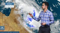
METEOROLOGIST, JONATHAN HOW: Hello from the Bureau with an update on Tropical Cyclone Iris off the north-east Queensland coast.
Over the past 24 hours, conditions over the Coral Sea have been favourable for tropical development, and on Sunday morning, Iris was renamed a Tropical Cyclone. It's currently a Category 1 system centered around 330km northeast of Townsville and moving southwest.
For the remainder of Monday, Tropical Cyclone Iris will edge closer to the coast as this track map shows, before turning south-east by Tuesday, and it could intensify to a Category 2 system. But as this system is quite far offshore, there is no current Tropical Cyclone watch nor Warning for coastal communities.
There is however a severe weather warning for parts of the Herbert and Lower Burdekin and Central Coast and Whitsundays. This includes places like Townsville, Hamilton Island and Mackay. These locations and adjacent coastal waters may see wind gusts in excess of 100km/h, particularly from Monday evening, and daily rainfall figures of 100 to 200mm are possible with higher isolated totals and we're already seeing large totals building across southern parts of the warnings area.
A flood watch is also current for catchments between Rollingstone and St Lawrence, with concern that further heavy rain may push waterways in the watch area into flood warning levels. The good news for residents of the Tropical North Coast is that the bulk of the rain should further south.
There is some uncertainty as to how Iris will move, but computer model guidance has the system moving away by Tuesday, and so a coastal crossing is unlikely, although severe weather is still expected for coastal parts and warnings will be updated accordingly. By Wednesday, the system should start to move away from the coast, and by Thursday should be offshore, but forecasters will continue to monitor Iris' movements given this uncertainty.
So if you're along the central Queensland coast as the long weekend draws to a close, please keep an eye on the forecast and any warnings, via the BOM website, app or Twitter. Always follow the advice of your local emergency services, and stay safe.
