


WEATHER UPDATE: Tropical cyclone Iris off the central coast of Queensland
05/04/2018
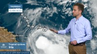
SENIOR FORECASTER, ADAM MORGAN: Hello from the Bureau with a final update on tropical cyclone Iris off the central coast of Queensland.
Iris has kept us all on our toes for almost 2 weeks now as she’s taken a grand tour of the Coral Sea.
Iris moved to the west as a tropical low during last week, and reintensified to cyclone strength off the north Queensland coast over the Easter break.
Tropical cyclone Iris reached category 2 intensity during Tuesday and Wednesday, and at 10 am this morning Iris remains a category 1 tropical cyclone, with the thunderstorm activity more located on the southern side of the system.
As forecast, Iris did gradually weaken in intensity during Wednesday and overnight, and we expect her to continue to weaken during Thursday, losing cyclone structure and returning to a tropical low by later this evening.
From there, we expect ex-tropical cyclone Iris to move towards the northwest along a track almost the same as where she came from.
With the main impacts of ex-tropical cyclone Iris to remain offshore over the coming days, all Cyclone Watch and Warning areas along the coast have now been cancelled, and Flood Watches have been finalised as well.
Strong winds are still expected along a number of coastal waters areas along the Queensland coast and a Gale Warning remains in place for the Great Barrier Reef offshore.
The focus area for rain and showers over the next few days should gradually move a little further north along the coast, and while there is the potential for some moderate falls, again, the heaviest falls are expected to remain offshore.
Unless the situation changes significantly, this will be our final Weather Update Video in this series for tropical cyclone Iris.
Make sure to stay up to date with our website and app for all the latest official forecasts and warnings.
