


WEATHER UPDATE: Heavy rain and a strong cold front for WA
04/06/2018
SENIOR METEOROLOGIST ADAM MORGAN: Hello from the Bureau with an update on unseasonal heavy rain and a strong cold front on the way for Western Australia.
For the southwest, this will be a windier wintertime cold front than usual, and will impact a broader area. On average we see fronts like this around about five times per year.
This event will have two parts. First off, after some rain develops over the South West Land Division during later this afternoon in association with an upper trough, heavier rain will move into western parts of the state during Monday night and Tuesday.
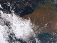
Rainfall through the Gascoyne and Pilbara will be unusually heavy and significant for this time of year, where we may see isolated totals of over 100 mm in some places, and some local flooding.
The heavy rain will also come with strong winds, gusting as high as 100 km/h over the western Gascoyne and northern Central West districts.
The second part to this weather system will be a strong cold front connected to a deep low pressure system moving into the Southern Ocean.
The pressure at the centre of the low will drop significantly on Tuesday – rapidly intensifying the system and tightening those isobars around it.
The cold front will approach the southwest Capes during the morning, and reach Perth during the afternoon.
Damaging winds up to 100 kilometres per hour are anticipated along the coast, and possibly stronger gusts locally, from Exmouth to Walpole from early on Tuesday, and then moving further east during the day as the front moves across.
The heaviest rainfall will be as the front passes during Tuesday afternoon, with up to 30mm likely along coastal areas and isolated falls of over 50mm possible.
South West Land Division agricultural areas will likely see rainfall more in the range 10 to 20 mm over the west, decreasing to less than 5 mm in the east.
As we head into Wednesday the heavier rain will extend further inland through the Pilbara, and we'll see some follow up showers for parts of the southwest.
The other hazard to watch out for will be much higher tides than usual, extending from Shark Bay to Walpole from late Monday through Tuesday, particularly around Geographe Bay area. High tides will have the potential to significantly erode beaches.
So make sure you stay up to date with the current weather warnings as the severe weather develops, by going to our website or app.
You can also follow us on social media for real-time updates from the Bureau and follow all advice from the Department of Fire and Emergency Services.
