


Weather Update: Ex-Tropical Cyclone Penny
07/01/2019
METEOROLOGIST DIANA EADIE: Hello from the Bureau. We're here with an update on the movement and development of Ex-Tropical Cyclone Penny.
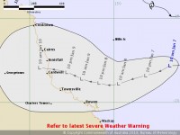
Ex-Tropical Cyclone Penny is currently located over the western Coral Sea, approximately 500 km to the east-north-east of Mackay.
The low is expected to continue moving towards the Queensland coast over the next couple of days, likely moving onto the coast during late Wednesday or early Thursday. The circulation could have periods of intensification and Penny remains a moderate, or 20-50%, chance of reforming into a tropical cyclone as it approaches the east coast.
Regardless of further development, heavy rainfall and damaging winds are likely to accompany the system as it approaches, then moves across the coast during the week, particularly on the southern side of the track.
Damaging winds may develop over the Whitsunday Islands tonight or early on Tuesday. Areas of heavy rainfall are expected to develop about coastal areas between Alva Beach and Sarina, extending inland during Tuesday and gradually shifting north.
A flood watch is current for coastal catchments between St Lawrence and Cape Tribulation. Given recent rainfall in the northern part of the watch area, some catchments are already saturated, and renewed river rises are a particular risk as the heaviest of the rain shifts north.
That’s all for now. As this is an evolving situation, please keep up to date with the latest forecasts and warnings on our website or through social media
