


Tropical low to track inland, with significant rainfall and strong winds
05/01/2015
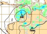
The Bureau of Meteorology is closely monitoring a tropical low pressure system currently located over Western Australia’s (northwest) Kimberley coast.
This slow moving system is likely to remain in the Kimberley region until later this week, when it is forecast to track further inland in a southeasterly direction.
The Bureau has issued Flood Warnings and Flood Watches for northern Western Australia and the Northern Territory today, with widespread daily rainfall forecast in the range of 40–60mm and isolated falls greater than 100mm likely.
As the system moves inland, rainfall and strong winds are also expected to impact the southern states of South Australia, New South Wales and Victoria.
With bushfires still burning in South Australia and Victoria there is a great deal of interest in the likelihood of significant rainfall across the fire grounds.
While some rainfall is forecast for these states, the system will also be accompanied by strong winds which may contribute to the already challenging conditions for firefighters. The location and intensity of the likely rainfall and winds will become clearer mid-week, and forecasts and warnings will be updated progressively.
High temperatures are also forecast to increase mid-week in South Australia, contributing further to potentially dangerous fire weather conditions.
As the system moves inland, the Bureau will be monitoring the system and working closely with emergency services partners to keep the public informed.
Members of the public are urged to remain mindful of the weather conditions in their local area, and when making travel plans.
Go to www.bom.gov.au or the Bureau’s new mobile website at m.bom.gov.au for the latest weather information and warnings.
