


WEATHER UPDATE: Severe tropical cyclone Trevor to cross the coast today, 19 March 2019
19/03/2019
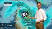
Senior Meteorologist, Dr. Adam Morgan: Hello again, Cyclone Trevor intensified rapidly overnight in the Coral Sea and is now a Category 3 severe tropical cyclone as it approaches the east coast of Cape York Peninsula today.
The cyclone Warning zone now stretches from Orford Ness to Cape Flattery on the east coast, to Pormpuraaw and Mapoon on the west coast. The Watch area extends north from Mapoon to Cape York.
Severe tropical cyclone Trevor will impact today. Communities in the Warning area on the eastern side of the Cape should complete preparations quickly and be prepared to shelter in a safe place.
People in western parts of the Cape should continue their preparations today.
Gales will increase along the coast today well ahead of landfall, and very destructive wind gusts are currently as high as 220 km/h near the centre of the system.
Currently around 85 km east-southeast of Lockhart River, there may even be enough time for Trevor to reach Category 4 intensity today before it crosses the coast late this afternoon or this evening.
Heavy rain and storm tides will also develop as well as Trevor approaches.
The rain risk extends further south from the system through Far North Queensland with those moist, onshore winds, and a Flood Watch is current for catchments right across the Cape north of Cairns to Kowanyama.
Although Trevor may weaken a little as it moves across the Cape and into the Gulf, it will remain a very dangerous system with those wind, rain and storm tide impacts continuing.
Trevor is then forecast to re-intensify quickly in the Gulf later this week.
Now, cyclones in the Gulf are notoriously erratic, and so the forecast track and intensity may change a lot between now and then, and the grey shaded area on the map here does show the range of track scenarios still possible.
Right now, the official forecast track takes Trevor near Groote Eylandt and then potentially across the southwest Gulf coast towards the weekend as a severe tropical cyclone.
It may well still be a few days away, but the cyclone threat for NT communities right around the Gulf is real and residents should begin planning their preparations.
If you're in the path of cyclone Trevor, finalise your preparations to stay safe.
Follow all advice from emergency services and check back with us on our website, app and social media for the latest official Bureau warnings, forecasts and updates.
