


WEATHER UPDATE: Severe tropical cyclone Trevor, 22 March 2019
22/03/2019
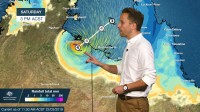
Senior Meteorologist, Dr Adam Morgan: Hello again. Severe tropical cyclone Trevor was this morning upgraded to Category 3 in the Gulf of Carpentaria.
Trevor will continue intensifying today as it heads towards the NT coast, And with severe tropical cyclone Veronica sitting off northwest WA as well, it's only the second time in Australia's history that we'll likely see two Category 4 or above cyclones cross the coast within 24 hours of each other.
A cyclone Warning is current across the Gulf from Cape Shield in the Northern Territory around to Karumba in Queensland. The cyclone Watch area extends from Ngukurr, inland towards Tennant Creek and around to the northwest Gulf country in Queensland.
Please finalise preparations today, follow directions from emergency services, and have your cyclone kits ready.
Severe tropical cyclone Trevor is a large system, with its destructive and damaging winds extending around 300 kilometres from the centre.
Gales may develop as early as this afternoon for islands across the Gulf, before extending towards the mainland coast tonight.
The latest track keeps cyclone Trevor heading towards landfall on Saturday between around Port MacArthur and the NT/Queensland border.
Within the core, wind gusts at landfall will be as high as 275 km/h, which will cause major infrastructure and vegetation damage.
Very dangerous storm tides combined with very heavy rainfall may cause inundation of low-lying areas.
Trevor may keep tropical cyclone intensity for at least 24 hours after landfall as moves inland, with heavy rain and damaging winds continuing.
We're looking at widespread 3-day rainfall totals of between 50 and 100mm as Trevor moves further inland, with heavier falls around the core.
As we know, roads can cut and communities become isolated very quickly in this part of Australia, so inland rains won't be good news for everyone.
A Flood Watch is current for the Carpentaria Coastal Rivers and Barkly regions.
We're with you all the way throughout tonight and the weekend as cyclone Trevor approaches, and our expert teams are monitoring its every move.
Official Bureau cyclone warnings and forecasts will be updated on our website and app regularly, and check in with us for updates on social media.
