


Intense wind, rain and possible flash flooding forecast for west coast this weekend and Monday
08/04/2021
People in western parts of the State from Onslow to Perth should prepare for a period of intense wind and rain that could lead to flash flooding over the weekend and on Monday.
Dangerous surf and storm surge will make conditions on the ocean treacherous.
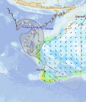
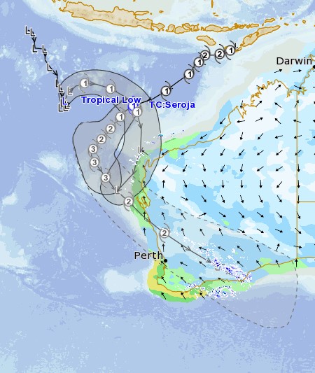
The reason such a large part of Western Australia is expected to be affected is because two tropical systems are expected to approach WA's coast at different times.
View the tracks of both systems here and below.
First system due to impact WA
The first impacts to WA are expected Saturday night in the Exmouth area with a brief, but possibly intense period of heavy rain and strong to gale force winds
This is from tropical low 23U, which is forecast to intensify to category 1 strength late today or early tomorrow, when it would then be named Tropical Cyclone Odette.
Heavy rain, while brief, may cause flash flooding.
Tropical cyclone Seroja's impact
Late Sunday or Monday Tropical Cyclone Seroja is expected to cross the coast as a Category 2, possibly category 3, most likely in the area between Carnarvon and Jurien Bay.
Destructive winds with gusts around 150 kmh and intense rainfall conducive to flash flooding are expected near the system as it moves over the coast.
Heavy rain and damaging winds are expected to continue inland through the Wheat belt on Monday.
TC Seroja is forecast to be travelling very fast so the worst conditions at any location will last from 3 to 6 hours.
While a direct impact to Perth is unlikely, a period of heavy rain and strong easterly winds is possible.
It's unusual for a tropical cyclone to cross the coast south of Carnarvon
Two main influences have led to TC Seroja's expected movement south out of the tropics.
The Fuijiwhara Effect, or the interaction between tropical low 23U and TC Seroja, have influenced TC Seroja to take a more southerly track.
Cyclones that form in April in the western region typically have a greater chance of moving south out of tropical regions.
Higher than normal tides are expected along the western coast.
Closer to where the system tracks significant storm surge is expected and could exceed Highest Astronomical Tide.
Stay up to date with all weather warnings here and cyclone information here.
ENDS
