
Winter is coming, and it's looking mighty mild
31 May 2018
After an exceptionally warm and dry autumn, it’s time to look ahead to see what’s in store for winter. Our climate outlook for winter, issued today, shows above-average temperatures and below-average rainfall are likely across southern Australia. While some will relish the prospect of a mild winter, the dry isn’t necessarily good news for everyone.
Warm lead-up to winter
Summer-like conditions continued into early autumn for much of southern Australia, including an exceptional heatwave in early April. Temperatures in autumn were warmer than average across much of the continent. New South Wales, South Australia, Western Australia and Victoria all experienced one of their warmest autumns since at least 1900. Overnight temperatures have also been warmer than average in most parts.
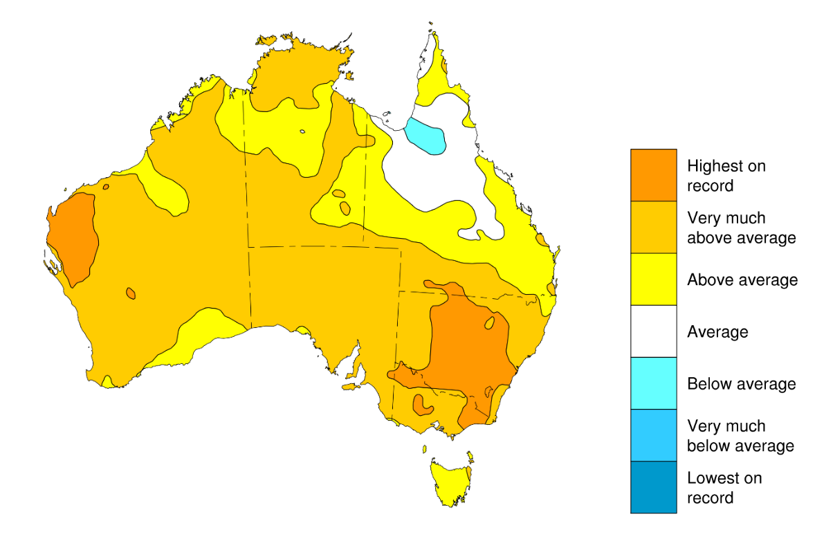
Image: Autumn maximum temperature map
Very dry autumn for the southern mainland
For many southern areas autumn wasn’t just warm, it was also extremely dry. New South Wales, Victoria, southwest Western Australia and South Australia all had one of their driest autumns on record.
Many farmers in southern Australia look to the autumn break—the first significant rain event (25 mm or more) after summer—to kick off the crop and pasture growing season. The autumn break arrived by mid-May across southern Victoria, eastern New South Wales and southwest coastal Western Australia. However, farmers in northwest Victoria, inland New South Wales, eastern South Australia and much of inland Western Australia didn’t receive an autumn break this year.
One of reasons for the warm and dry autumn in the south was higher than average pressure over southern Australia. The high pressure meant rain bearing cold fronts from the Southern Ocean couldn’t push up into southern Australia.
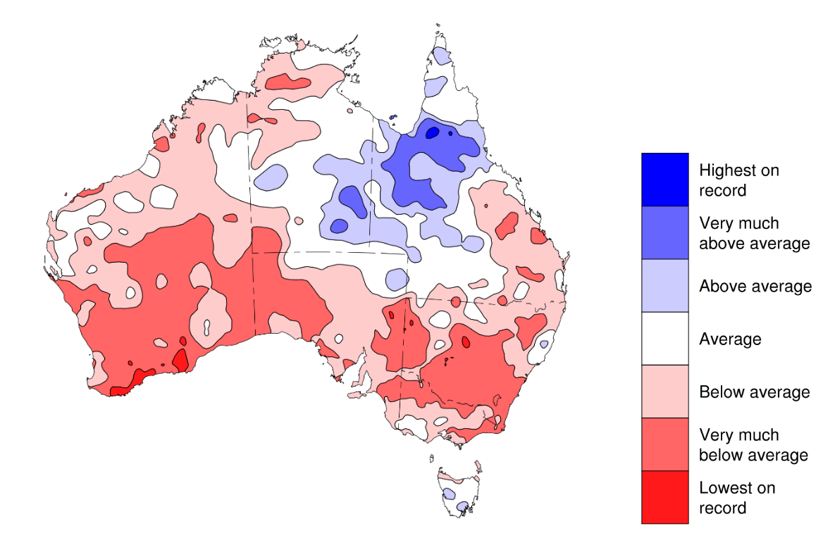
Image: Autumn rainfall map
No strong influence from Pacific or Indian Ocean this winter
So, will this pattern of warm and dry continue? Two of the major drivers of Australia’s climate, the El Niño–Southern Oscillation (ENSO) in the Pacific Ocean, and its equivalent in the Indian Ocean, the Indian Ocean Dipole (IOD), were neutral during autumn, and are likely to remain so throughout winter.
Of the eight international climate models we survey, seven predict winter will see ENSO-neutral sea surface temperatures in the central Pacific, with only one model forecasting a warming to El Niño levels by August.
Models also suggest the Indian Ocean Dipole (IOD) will remain neutral through winter. But there is quite a range of scenarios from the international modelling centres the Bureau assesses. One model is predicting a positive IOD over winter, one model predicting a negative IOD in spring, and the other four are neutral. Typically, when the ENSO and IOD are both neutral there is no strong shift in the outlook towards widespread wetter or drier conditions across most of Australia.
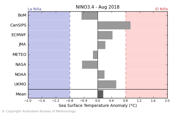
Image: Most international model outlooks for the ENSO sea surface temperature index in the central Pacific Ocean (NINO3.4) remain neutral in August.
Model outlooks provided by: BoM (Bureau of Meteorology), CanSIPS (Canadian Seasonal to Interannual Prediction System), ECMWF (European Centre for Medium-Range Weather Forecasts), JMA (Japan Meteorological Agency), Météo France, NASA (National Aeronautics and Space Administration), NOAA (National Oceanic and Atmospheric Administration), and the UKMO (United Kingdom Met Office).

Image: Most international model outlooks for the IOD sea surface temperature index remain neutral in August.
Model outlooks provided by: BoM (Bureau of Meteorology), CanSIPS (Canadian Seasonal to Interannual Prediction System), ECMWF (European Centre for Medium-Range Weather Forecasts), Météo France, NASA (National Aeronautics and Space Administration), and the UKMO (United Kingdom Met Office).
However, when these major drivers are neutral, other factors can have a greater influence on Australian rainfall and temperature patterns. For instance, forecast warmer-than-usual temperatures in the Tasman Sea and the associated lower-than-normal air pressure this winter is likely to contribute to a weakening of westerly winds over southern Australia that would normally draw cold fronts up from the Southern Ocean.
So, what’s the outlook for winter?
As a result of the weakened westerly winds, below-average winter rainfall is likely for western parts of Western Australia, and for most of New South Wales extending across the border into southern Queensland and northern Victoria. For most other parts, the outlook is neutral, meaning roughly equal chances of above- or below-average rainfall.
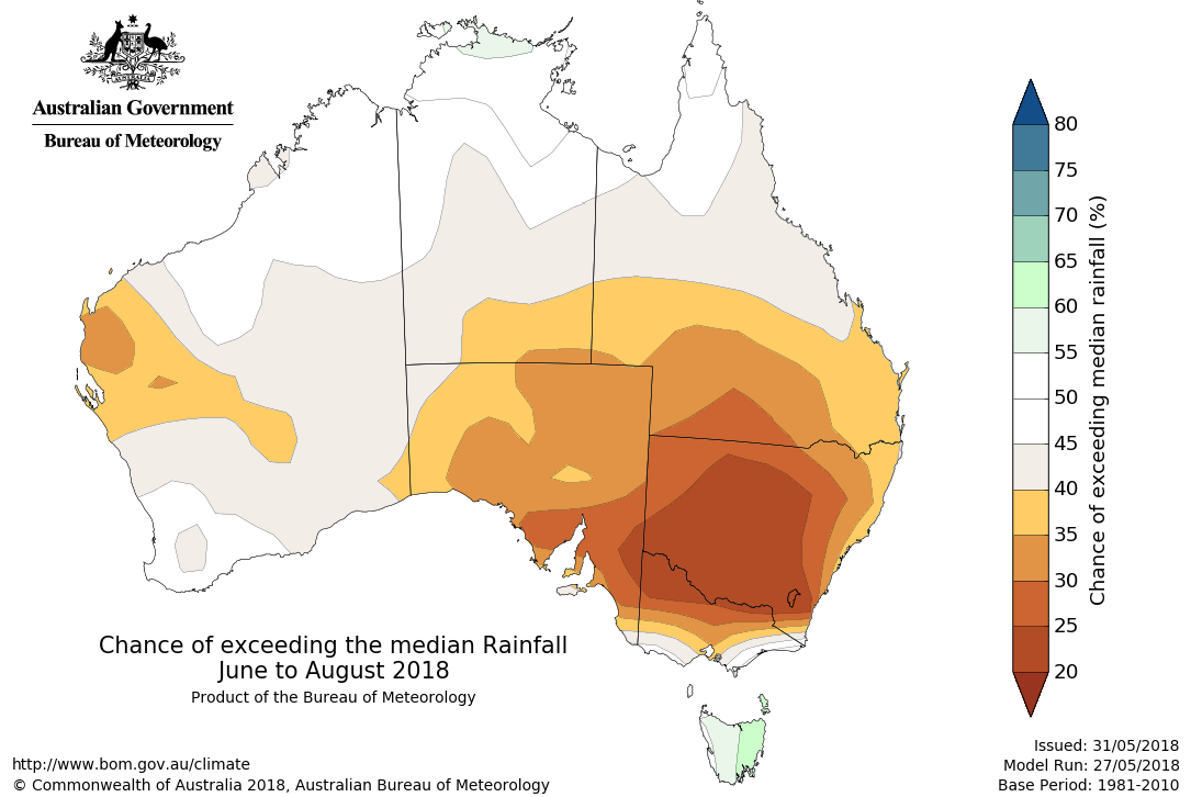
The outlook for June is looking particularly dry across most of the southern mainland.
The likely reduction in cold fronts, and clearer skies over much of the continent means warmer-than-average temperatures are favoured across southern Australia, with the strongest likelihood (about 80 per cent) in the southeast.
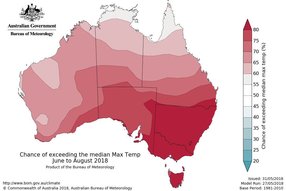
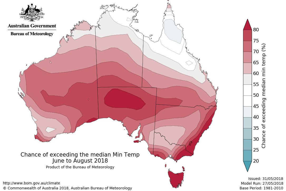
The model suggests there is also an above-normal likelihood of winter 'mildwaves'—periods of very mild weather—along Australia’s southeast coast.
So, what does this all mean? For farmers and those working in the agricultural sectors, the warmer temperatures mean soils will stay warm longer. This is likely to keep the crop and pasture growing window open a little longer before the cold of winter. Dry conditions are likely to mean a slow and possibly late start to the growing season, potentially pushing the crop harvest later into the warmer months of 2018, when heatwaves can become a problem.
What does this mean for the snow season?
For skiers, a later start to the season becomes more likely with a warm and dry June expected. On the other hand, neutral ENSO conditions typically bring snow cover that’s a little deeper than average by mid-season.
This is a contrast to strong El Niño or La Niña phases, which both typically mean less snow than usual, but for different reasons. El Niño phases mean less rainfall and warmer days during the snow season. La Niña years usually have more rain, but temperatures can be too high for snow to form.
This has happened more often in recent decades because of climate change. Historically, neutral years have had more consistent good snow depths than either El Niño or La Niña years, so late winter should be a good time to hit the slopes.
Read more
For more details on the long-range forecast for winter, visit our Climate Outlooks website and subscribe to Climate Outlooks to stay on top of what’s happening with the climate. A complete set of Climate Summaries covering May and autumn 2018 will be available on 1 June.
When is it going to snow? Getting a fix on what can make a good season
Droughts and flooding rains: it takes three oceans to explain Australia's wild 21st-century weather
Explainer: El Niño and La Niña
Winter heatwaves are nice ... as extreme weather events go![]()
This article was originally published on The Conversation. Read the original article.
![]()
Subscribe to this blog to receive an email alert when new articles are published.

Comment. Tell us what you think of this article.
Share. Tell others.