


Queensland warned of damaging winds and heavy rainfall from Friday
14/07/2016
An upper trough will intensify over western Queensland tomorrow (Friday) and remain slow moving on Saturday, generating damaging winds and heavy rainfall for the coastal regions south of Mackay, including Yeppoon and Gladstone, and adjacent inland areas including Rockhampton and Emerald.
A Severe Weather Warning has been issued Thursday afternoon for the Central Highlands, Coalfields, Capricornia and parts of the Central Coast and Whitsundays Forecast Districts.
A Flood Watch was also issued for the Fitzroy, Barcoo, Warrego, Maranoa and Southern parts of the Burdekin River Catchments. Rainfall may result in localised flash flooding and river and stream rises.
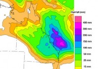
Rainfall associated with the trough will affect much of the state from the Cairns coast south, and inland as far as west as Longreach - check the Bureau's website for forecast rainfall in your local area.
Daytime temperatures underneath the rain band will be much colder than average for this time of year, particularly through the interior.
Members of the public are urged to stay tuned for updated forecasts and warnings, follow the advice of local emergency services and remember if it’s flooded, forget it. Do not drive, ride or walk through flood water.
Residents who require flood and storm emergency assistance should contact the State Emergency Service (SES) on 132 500. In a life-threatening emergency dial Triple Zero (000). For more information on floodwater safety visit www.qld.gov.au/floodwatersafety
For the latest warnings issued by the Bureau of Meteorology go to www.bom.gov.au/warnings
The Bureau is also using Twitter to disseminate significant weather information for the community. Follow us @BOM_QLD. The Bureau's website remains the most up-to-date and comprehensive official source of information.
