


Spring outlook points to warmer temperatures for the north and southeast
31/08/2017
The Bureau of Meteorology has released its official spring outlook today – indicating a mix of climate conditions for Australia’s season ahead.
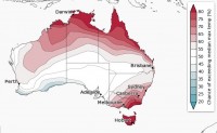
The Bureau’s Climate Prediction Manager, Dr Andrew Watkins, said that while spring days and nights are expected to be warmer than average for the north and southeast of the country, clear nights mean the risk of frost will continue—particularly in areas with drier soils.
“The rainfall outlook for September to November indicates below-average rainfall is likely for south western parts of Western Australia, however there is the possibility of above-average rainfall in areas near southeast Queensland and far east Gippsland,” Dr Watkins said.
“While Australia's main climate drivers—the El Niño-Southern Oscillation and the Indian Ocean Dipole— are both neutral, other climate drivers are likely to influence spring.
“Warm waters in the central Indian Ocean may result in higher pressures south of Australia, resulting in more easterly winds, keeping the west drier than average.
“We’ve just experienced a very warm and dry winter. In fact, daytime temperatures were at record-high levels across much of the country this winter.
“These warm and dry conditions have meant fire potential in parts of eastern Australia has been unusually high this winter. Bushfires have already occurred in northern New South Wales and southern Queensland.
“In contrast, winter nights have been notably cooler than average in areas such as the Murray–Darling Basin,” he said.
Scott Williams, Senior Forecaster at the Bureau said a brief taste of spring this week will be replaced by blustery conditions across much of southeastern Australia from the weekend.
“After a chilly morning with inland frosts, the southeast of the country can expect a settled first day of spring with plenty of sunshine and light winds. Temperatures will struggle though with south eastern capitals only reaching 16-18 °C.”
“The first few days of spring will bring changeable weather across the south as a cold front moves across South Australia Saturday then Victoria, Tasmania and southern New South Wales on Sunday,” he said.
The Bureau’s rainfall and temperature climate outlooks show the likelihood, as a percentage, of experiencing wetter or drier and warmer or cooler than average weather for the upcoming three months.
They are used to inform a range of decision-makers across industries such as agriculture, water, emergency services and energy and resources. To view the full outlook and watch our climate and water outlook video: www.bom.gov.au/climate/outlooks
A video of press conference recorded at 10am on 31 August the Bureau of Meteorology Head Office in Melbourne is available here:http://media.bom.gov.au/downloads
