


Severe Weather Update Transcript: Fire danger & cold front, Western Australia and South Australia
15/12/2017
METEOROLOGIST ADAM MORGAN: Significant fire danger over parts of Western Australia this weekend will be followed by a strong cold front that will make it feel more like winter over the southwest during Sunday.
Now hot, dry and windy conditions around a broad low pressure trough will see 'Catastrophic' fire danger over the Goldfields on Saturday and 'Extreme' fire danger over the Inland Gascoyne region as well.
Now these conditions mean that any going fires will be difficult to control.
Now 'Severe' fire danger is also expected for many other regions, including the Eucla and the Central Wheat Belt as well.
Now on Sunday the area of 'Extreme' fire danger moves further east into the Southern Interior and the Eucla in Western Australia.
We're also likely to see some 'Severe' fire danger move into South Australia as well.
We'll see 'Very High' to 'Severe' fire danger for many remaining districts through the southern and southwestern parts of Western Australia.
But Sunday will also see a sharp change in the weather across the South West Land Division, as a strong cold front crosses the south of the State.
Now the cold front will approach the southwest capes during Saturday. It's moving up from the Indian Ocean here and by Saturday night – early Sunday we'll just see the cold front just move into the southwest of the State.
And during the day on Sunday that cold front will extend wet and windy conditions across the southern parts of the State—including thunderstorms south of approximately a line between Perth and Albany.
Now this low pressure system will also generate large waves and swell thanks to that tight pressure gradient (just on that western side of the low there where those isobars are spaced closer together), so it's possible we'll see dangerous surf conditions develop between about Lancelin and Albany.
So it's likely we'll issue a Severe Weather Warning for this cold front as we get closer to Sunday, so make sure you stay up to date across the weekend.
Now this kind of weather pattern and deep low pressure system moving up from the south is unusual for this time of year, and is more common to winter in southern WA than summer.
In fact, maximum temperatures across much of the southwest of WA on Sunday and Monday will be more than 8–10 °C below average for December, with many locations struggling to reach the high teens or low 20s.
Now just 21 °C is forecast for Perth on Sunday, and 22 °C on Monday.
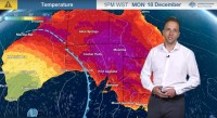
Now those hot and windy conditions will move further east on Monday into South Australia: You can see this purple area here—very warm temperatures ahead of this front—and we'll likely see, with those windy conditions as well ahead of the change, 'Severe' fire dangers for many districts.
So head to the Bureau's website and app for all the latest warnings and forecasts over the weekend, and join us on Twitter for updates direct from the Bureau's meteorologists, and follow all advice from emergency services.
