Spring outlook shows dry conditions likely to continue
30/08/2018

Issued: 30 August, 2018
The Bureau of Meteorology has released its 2018 Spring Outlook which shows warmer and drier than average conditions are expected across many parts of Australia in the coming three months.
It follows what has been one of the warmest winters on record for maximum temperatures across the country as a whole.
Bureau of Meteorology manager of long range forecasting Dr Andrew Watkins said much of the eastern mainland had experienced an exceptionally dry 2018 and the outlook is not great news for farmers in drought-impacted parts of the country.
"These regions need a lot of rain to break the current drought," Dr Watkins said.
"Like all Australians, all of us at the Bureau of Meteorology are hoping those affected by the drought will get the rain they need soon.
"Unfortunately, our outlooks show odds favouring a drier and warmer than average spring for many areas."
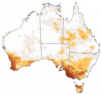
The outlook suggests spring rainfall is likely to be below-average for much of mainland Australia, with strongest chances (above 80 per cent) of a drier-than-average season in southern NSW, Victoria and southwest WA.
Daytime temperatures during Spring are expected to be warmer-than-average, with the strongest chances (above 80 per cent) in the north and west of the country. With low rainfall and clear skies likely, the risk of cold nights and frost continues in the south, but overall, warmer than normal overnight minimums are likely in many locations for spring.
One of Australia's main climate drivers, the El-Nino-Southern Oscillation (ENSO) is currently in a neutral phase, however the Bureau's ENSO Outlook is at El Niño Watch. This means the chances of an El Niño forming in the coming Spring are 50%, roughly double the normal chances.
"Traditionally El Niño events result in warmer and drier than average conditions across eastern Australia.
"However, it is important to remember that the strength of an El Niño event doesn't always translate into the conditions we see.
"For example, in the past we've had strong El Niño events accompanied by mild conditions and weaker El Niño events accompanied by severe conditions.
"A number of international models are also predicting a positive Indian Ocean Dipole event could potentially develop during spring which would further exacerbate the drying trend."
The 2018 Spring Outlook is the first end-of-month seasonal outlook produced using the Bureau's upgraded climate outlook model.
The new model better simulates regional climate patterns, providing more accurate and localised outlooks than was previously possible using past models.
The Bureau's winter summaries will be released on Monday, September 3, but preliminary figures suggest this winter will be among the top five warmest on record in terms of maximum temperatures for Australia as a whole.
Winter rainfall has also been below average through large parts of eastern Australia, northwest WA, central Australia, eastern SA and southern WA.
View the latest outlook: http://www.bom.gov.au/climate/outlooks/#/overview/summary
Videos and maps are also available: http://www.bom.gov.au/climate/ahead/
Please find below video news releases for each state. These were recorded with Bureau climatologist and Manager of Long Range Forecasting Dr Andrew Watkins:


