


Some relief from heavy rainfall, widespread flooding continues across Queensland
09/02/2019
The tropical low on the monsoon trough continues to move east over the Coral Sea, taking much of the heavy rainfall which caused widespread flooding in Queensland with it.
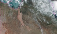
Queensland Flood Services Manager Victoria Dodds said while sunny conditions have returned for much of the state, satellite images reveal the extent the flooding on the Flinders River where tragically, widespread agricultural impacts and stock losses have been reported.
"Flooding in the Flinders, the longest river in Queensland, is the most significant we have seen in more than 50 years, with flooding likely to continue well into next week.
"Major flooding is expected to continue at Walkers Bend where the Flinders River cuts access to the Gulf town of Normanton via the Burke Development Road. Levels may exceed the 1974 flood level of 15.67 metres, with higher levels possible.
"Our focus remains on providing detailed hydrology and flood forecasting services for large areas of the state.
"Many catchments and river systems are still impacted by flood waters, and some are likely remain so for days and weeks to come. Satellite imagery and drone footage has revealed the vast nature of the flood crisis in Queensland and our thoughts are with all those affected.
"We are in regular contact with state and local government authorities, providing flood forecasting services to inform recovery efforts and getting aid to areas where it is needed—with many roads still cut," said Ms Dodds.
"Flooding in the Ross River is now at the minor level and falling, after the extraordinary rainfall, including 1872mm at Upper Bluewater and 1758mm at Paluma, over a 7-day period."
Hot and humid conditions will affect the northeast tropics, including Townsville, making the recovery effort more physically challenging.
