


Statement on Bureau services for North Queensland and Townsville radar
05/03/2021
The Bureau of Meteorology is continuing to monitor and provide forecasts and warnings about Tropical Cyclone Niran, which continues to move away from the north Queensland Coast.
Our meteorologists are using a broad range of data sources to track and monitor the cyclone's movements and its impact on the mainland and on island communities.
These include satellites, upper atmosphere observations, automatic weather stations and radars located along the Queensland coast.
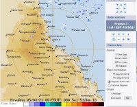
The Townsville radar is again operational after an equipment fault occurred last weekend. Images from the radar came online yesterday at around 2.30pm AEDT.
Fixing the radar was a priority for the Bureau as we understand the importance of the images to the local community.
The BOM Weather app has continued to display radar images of Townsville this week, throughout the radar outage. This is because the Bureau uses overlapping images from other nearby radars, such as the one located at Bowen.
Radars are very complex machines that run 24/7 and, from time to time, can experience a significant issue that takes time to repair.
The Bureau runs a routine six-monthly maintenance schedule for each of its radars.
Radars in North Queensland are always serviced ahead of the summer cyclone season – the Townsville radar was serviced in October 2020 and will have its next service in April 2021.
The Cairns, Willis Island, Bowen, Townsville and Mackay radars are all currently operational.
In addition to our radars, the Bureau has other tools the community can use to monitor the weather – including the satellite viewer on the Bureau website at http://satview.bom.gov.au/ as well as graphical weather service MetEye.
The latest information about TC Niran and its likely impacts is available at http://www.bom.gov.au/cyclone/
