


Flurry of winter cold fronts move across WA's south west
02/07/2021
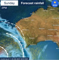
A series of cold fronts moving along WA's south coast will bring showers and strong to gale force winds from Sunday into the middle of next week.
From Kalbarri to Esperance and areas in between a mostly clear start to the weekend will give way to showers and isolated thunderstorms during Sunday with expected two-day total falls to 9am Tuesday of 5-40mm and up to 80mm in isolated areas in the far southwest.
For Perth 15-40mm of rain is expected during Sunday and Monday.
Strong to gale force winds are expected on Monday around the south west capes and south coast with further showers.
Dangerous surf and higher than normal tides are likely in coastal areas from Jurien Bay to Albany.
Showery and windy conditions will continue into Wednesday across the south west as a low pressure system moves through late Tuesday and during Wednesday.
This wet and windy period is typical of the type of weather the south west of WA experiences each winter.
