


Winter cold fronts set to return to southwest WA
06/08/2021
Sunny skies across WA will give way to showery and gusty conditions this weekend and continue into early next week across the west coast and southwest of the state.
Following a brief reprieve from weather that led to the wettest July on record across many parts of greater Perth and the wettest July since 1996 for the broader South West Land Division (roughly south-west of a line between Geraldton and Esperance), more wintery cold fronts are again expected.
A cold front will move over southwest WA late Saturday. Two strong cold fronts will then arrive overnight Sunday, and later on Monday, with impacts extending into Tuesday.
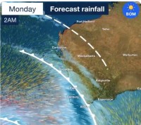
The initial front will bring 10-15mm of rainfall across the southwest, with isolated falls of 20-25mm along and west of the Darling Scarp south of Lancelin and east along the south coast to Albany.
Rainfall is expected to start Saturday over the western Gascoyne and extend south, with falls beginning Saturday afternoon in Perth.
Strong cold fronts expected overnight Sunday and later Monday
The first of two strong cold fronts will begin affecting the southwest Capes late Sunday evening and be felt in Perth near midnight.
Damaging wind gusts to 100 km/h mainly about coastal areas from Lancelin to Albany and rainfall of 10 to 15 mm with isolated falls of 20 to 25 mm on and west of the Scarp south of Lancelin and east along south coast to Albany are expected.
The second, stronger cold front will move through from Monday afternoon, reaching Perth early Monday evening.
Damaging wind gusts up to 110kmh are possible from Jurien Bay to Bremer Bay, with locally destructive wind gusts to 125kmh possible about the South West Capes.
Widespread rainfall totals of 15-20 mm southwest of Jurien Bay to Albany with isolated falls of 25-35mm about the south coast west of Albany and on the Darling Scarp.
Very windy conditions are expected to persist over southern parts of the South West Land Division from midday Monday through to Tuesday evening.
Dangerous surf, high tides and flooding
Dangerous surf conditions from Shark Bay to Israelite Bay and higher than normal tides from Jurien Bay to Esperance are expected.
Forecast rain on wet southwest catchments may trigger renewed flooding and associated watches and warnings over southwest WA.
Severe weather warnings may be issued from Sunday.
Stay up to date with warnings here.
