
Tropical cyclones: just for the tropics?
05 April 2017
If you don’t live in Australia’s tropical zone, you might think tropical cyclones need only concern northerners—but it’s not quite as simple as that. While our tropics are most prone to the direct impact of tropical cyclones, they or their effects can be felt as far south as Perth on the west coast, and across the border into New South Wales on the east coast. So what are those effects and which cyclones have caused them?
The most common effects we experience in non-tropical areas are heavy rain and associated flooding after a cyclone has weakened. However, some cyclones that remain over water can still produce gale-force winds when they move outside the tropics, even though they lose their tropical cloud patterns and become ‘extra-tropical’.
New South Wales
Tropical cyclones have caused flooding, destructive winds, storm surge and loss of life in New South Wales.
From the east
Tropical cyclones have directly affected land areas of New South Wales from the east, causing flooding and fatalities. Examples include tropical cyclone Nancy in 1990 and an unnamed severe tropical cyclone in 1954.
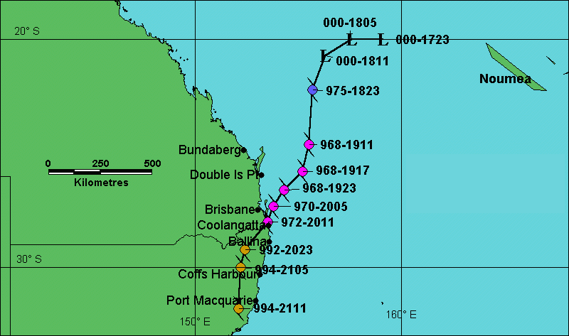
Tropical cyclone Nancy (shown below) caused heavy rain between the coast and coastal ranges south of Brisbane in February 1990 before moving seawards again. This resulted in flooding within New South Wales and Queensland.
A severe tropical cyclone (shown below) crossed the coast near Tweed Heads in February 1954, then moved southwards inland from Ballina, Coffs Harbour and Port Macquarie at category 1 strength. It had a major impact in southeast Queensland and northeast New South Wales, with many lives lost. Were a similar event to occur now with a densely populated southeast Queensland and northern New South Wales it would be extremely dangerous—with riverine flooding and coastal storm surges a major threat to communities.
Overland from the Gulf of Carpentaria
Tropical cyclones have tracked inland from the Gulf of Carpentaria, often moving through to New South Wales as ex-tropical cyclones with significant impact. Examples include:
- Audrey in January 1964, which tracked overland until it crossed the coast again at Coffs Harbour, leaving a trail of destruction over inland New South Wales;
- Oswald in 2013, which caused severe flooding across central and southeast Queensland and northern New South Wales; and
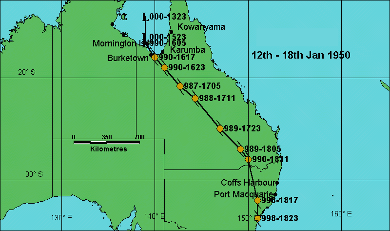
- an unnamed ex-tropical cyclone that tracked all the way to Sydney in January 1950 (shown below).
Offshore tropical cyclones
Cyclones well offshore of Australia’s east coast can affect New South Wales coastal areas, generating large swells that may cause beach erosion, heavy rain leading to flooding, and storm surges. Examples include:
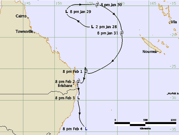
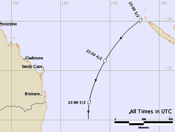
- tropical cyclone Pam in 1974 (shown below), which caused huge waves and damage on Sydney beaches; and
- tropical cyclone Yali in 1998, which caused large waves and beach erosion about northern New South Wales beaches.
Southwest Western Australia
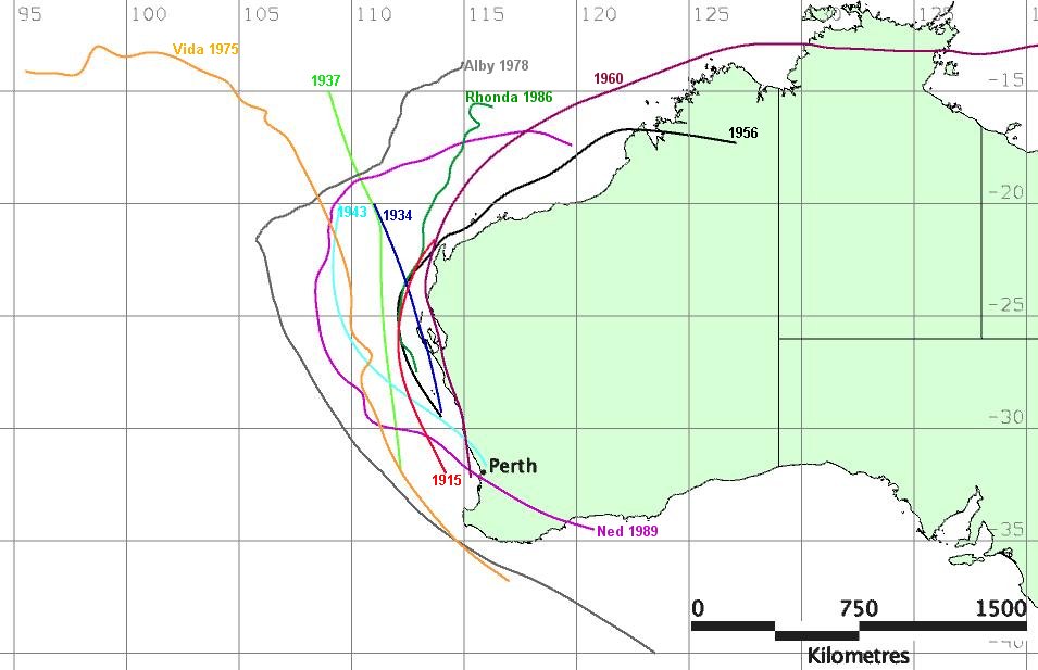
Since 1910, there have been 14 tropical cyclones that have produced gales or wind-related property damage in the Perth region. The map below shows some of the notable ones.
Severe tropical cyclone Vance
The remains of severe tropical cyclone Vance tracked over southern Western Australia in 1999 and caused flooding that closed the main highway and rail link to the eastern states. They also caused gale force winds over parts of South Australia and Victoria.
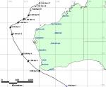
Severe tropical cyclone Alby
In April 1978, severe tropical cyclone Alby (shown below) proved that although very few cyclones reach so far south, they certainly can—and are still dangerous when they do. Alby passed close to Augusta causing gale-force north to northwest winds. Five lives were lost. Damage to property was widespread and was most severe in the region between Mandurah and Albany.
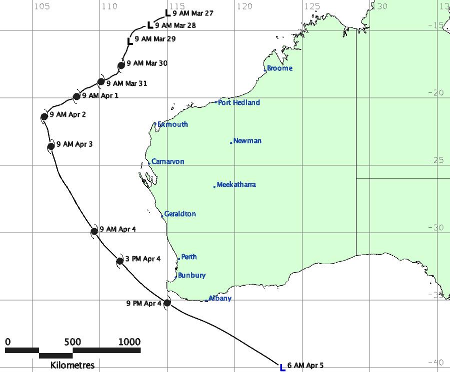
Alby never made landfall, but the hot winds that it brought, along with very little rain over land, resulted in numerous out-of-control bushfires. The widespread bushfires and severe dust storms reduced visibility to less than 100 m over a large area. Storm surges and large swells flooded low-lying areas and caused erosion along the coast. Due to the extensive damage caused by the cyclone, the name Alby was retired from the list of Australian cyclone names.
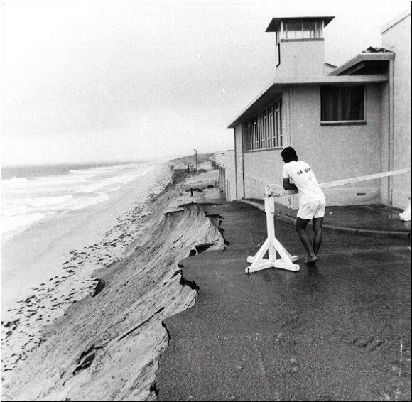
Image: Coastal erosion on Perth's beaches caused by severe tropical cyclone Alby. Photo reproduced courtesy of The West Australian.
Historical accounts of cyclones affecting Perth
Of the early accounts, cyclones affected Perth in 1845, 1867 and 1871. Possibly the most severe summer storm of that time occurred in 1872, as described in Results of Rainfall Observations made in Western Australia (published in 1929):
In Perth a storm of unprecedented severity occurred on the 10th March. About 7 am heavy rain fell, and from then for about five hours the gale raged with unabated fury. At noon the barometer read 29.20 inches, and the wind blew from eastnortheast. The destruction of property within the city was considerable, chimneys having been blown down and trees levelled to the ground. Telegraph communication was cut off between Perth and Fremantle, also beyond Guildford and between Pinjarra and Bunbury. The town hall of Perth and the Colonists Hospital were greatly damaged, Several cottages were blown down but no lives were lost.
At Bunbury, the town was visited by a most violent storm of wind and rain. The barque Midas dragged her anchors and finally ran aground and became a total wreck. The storm came from the northeast and north without warning. From noon it blew with utmost fury until about 4 pm, when it began to gradually abate.
At Fremantle the port was visited by the most extraordinary weather that had been witnessed for some considerable time at that period of the year. The wind was so terrific that huge stones were lifted a distance of several feet from the ground.
More information
- Current tropical cyclones
- Previous tropical cyclones
- Video: How do tropical cyclones get their names?
- Video: Understanding tropical cyclone categories


Comment. Tell us what you think of this article.
Share. Tell others.