
Summer weather: what you need to know
12 December 2017
Updated 1/11/19
Australia comes alive in the summer! With longer daylight hours, there's an abundance of outdoor events and adventures on land and water. But it's also a time when the weather can put you at risk. Here's what to look out for this summer—and how to keep yourself and your loved ones safe.
Ultraviolet (UV) radiation
Why take notice: Australia has one of the highest levels of ultraviolet (UV) radiation in the world and it's the major cause of skin cancer—a disease that kills more than 2000 Australians each year, according to Cancer Council Australia. UV damage also includes sunburn, premature ageing, and eye damage.
While UV is a danger all year round, we typically see the highest levels during summer months. The cooler days during summer can be the most deceptive; remember, UV levels are not related to heat—and you’re still exposed on a cloudy day.
Reflection increases the amount of UV you are exposed to. For example:
- Sitting on the beach, you’ll get an extra 20 per cent of UV reflected from the dry sand.
- On a boat, you'll get an extra 10 per cent reflected from the water, and another 10 per cent reflected from your boat.
How to stay safe: Sun protection times and UV levels are included in our forecasts. Check your forecast at www.bom.gov.au, or by tapping on today's weather icon in the BOM Weather app. You can also use the SunSmart app to find out sun protection times for your location, plus current UV levels.
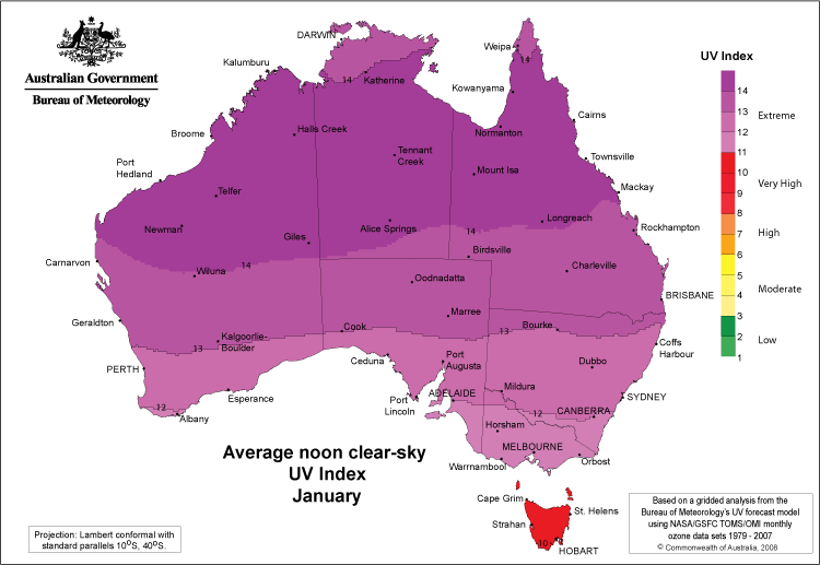
Image: January's average UV index for noon and under clear-sky conditions—all of Australia is ‘Very High’ or ‘Extreme’.
Hot nights
Why take notice: When people think of heatwaves they often focus on maximum (daytime) temperatures, which can certainly impact on our daily activities. However, unusually high minimum (or overnight) temperatures are critically important in making heatwaves so dangerous.
Hot nights prevent our bodies, buildings, and landscapes from discharging heat and can stop us from recovering from heat exhaustion. And if the minimum temperature remains high, then the subsequent daytime heat will be higher for a longer period.
Heatwaves don’t just leave us tired and uncomfortable though—they are described as a 'silent killer'. In the last 200 years, severe and extreme heatwaves have taken more lives than any other natural hazard in Australia (1).
Heatwaves are most common between November and March.
How to stay safe: Our Heatwave Service shows when and where heatwaves are developing for the next three days, which can help you prepare or change your plans to cope more easily in the heat. The service uses a heatwave intensity index that assesses the build-up of heat over a period of time, taking into account the long-term climate of a location and the temperatures leading up to the heatwave event. This is a more advanced indicator than temperature alone.
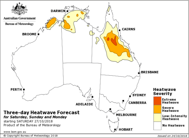
Image: Heatwave Forecast map showing locations where heatwave conditions are expected, and their intensity (low, severe or extreme).
Thunderstorms
Why take notice: Thunderstorms can cause a lot of damage to people and their property. They can occur at any time of the year, but most strike between September and March. Of most concern are severe thunderstorms which produce large hail, damaging wind gusts, tornadoes, and heavy rainfall. These storms are more likely to disrupt essential services (such as power and transport), damage our cars, houses, and crops, and most importantly, cause serious injury or death. Lightning, produced by any thunderstorm, can also ignite bushfires.
If you're a boater, thunderstorms are particularly dangerous. They can generate strong, squally winds that make your boat hard to control and heavy rain that reduces your visibility. There is little protection out on the water from hailstones, lightning, or waterspouts.
Watch for approaching cumulonimbus clouds—dense towering, tall clouds—as these are associated with thunderstorms. Tune into the media and local radio, and listen to the advice of emergency services.
How to stay safe: Check our website or the BOM Weather app for the latest forecasts and warnings.
- Watch for mentions of thunderstorms in town forecasts up to seven days in advance, and in coastal waters forecasts three days in advance.
- Pay special attention when we issue a Severe Thunderstorm Warning.
- Keep an eye out for darker colours on the radar (where available), indicating heavy rain.
- Check out the satellite image with recent lightning strikes (click on 'Layers' in the bottom left of our satellite viewer and then select Lightning)
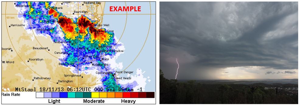
Images: Radar image showing heavy rain and thunderstorms in orange, red and black (left); thunderstorms in action (right).
Marine hazards
Why take notice: Summer is a perfect time to get out on the water, but this means it’s also the peak time of year for drownings and other water-related incidents. According to Surf Life Saving Australia, 122 people drowned in Australia's coastal waters during 2018–19. The majority of deaths occurred while swimming or wading (43 deaths), boating (17 deaths) and using watercraft (10 deaths)(2). Overall 42 per cent of drowning deaths happened over the summer months.
Weather is vital for the safety and enjoyment of marine-based activities such as boating, sea kayaking, and fishing. Take note of forecasts indicating reduced visibility from fog or rain, thunderstorms, and/or hazardous wind, squall and wave conditions. Remember that conditions can change quickly.
How to stay safe: We provide marine weather forecasts, warnings and observations for local waters, coastal waters areas and high seas around Australia. These will help you make the right choice on when and where it's safe to be out on the water.
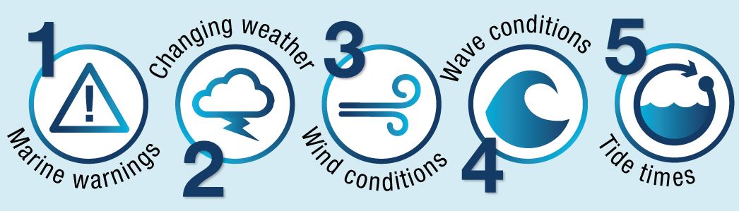
Before heading out, use our marine forecasts and warnings and run through the five vital weather safety checks:
When planning your activity, the online mapping tool MetEye provides detailed information on forecast winds, waves and weather conditions for waters out to 60 nautical miles from the coast, as well as for some popular inland lakes. View our video on how to use MetEye for marine activities.
We issue warnings specific to marine areas, including Marine Wind Warnings, and Hazardous Surf Warnings (for NSW and southern Queensland) that will be listed on our national warning page and the warnings section of the BOM Weather app. MarineLite provides text-only forecasts and warnings, and 'lite' charts, which are smaller and faster to download.
Boaters should tune into their local VHF marine radio station for the latest weather advice.
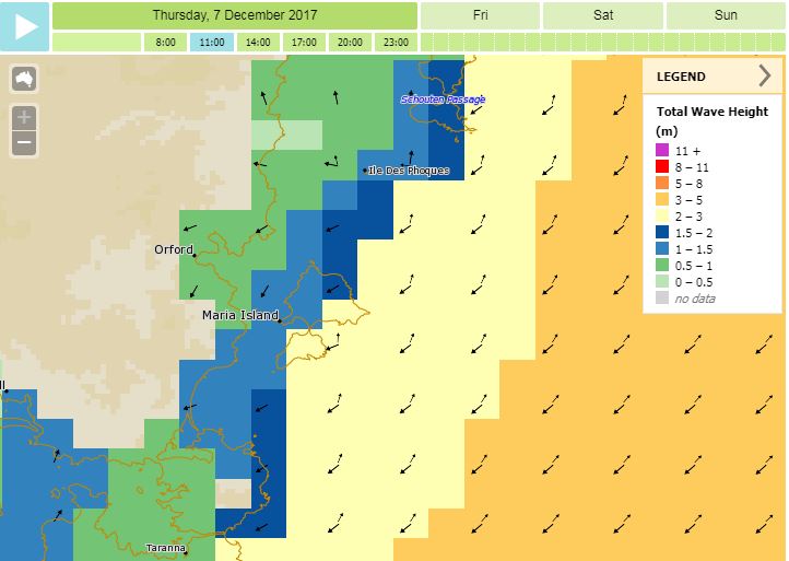
Image: Three-hourly wave forecast from MetEye.
Other hazards
Australia also experiences a range of less frequent weather hazards. During the summer, watch for bushfires, flooding, and tropical cyclones, and take care of yourself and your loved ones!
For information on other summer weather hazards, see:
The Bushfire and Natural Hazards CRC's bushfire outlook has more on what to expect from this fire season.
More information
Keep an eye on the weather outlook for the upcoming months with the seasonal rainfall and temperature outlook.
(1) Coates et al. 2014. Exploring 167 years of vulnerability: An examination of extreme heat events in Australia 1844–2010. Environmental Science & Policy 42 (2014) 33–44.
(2) Surf Life Saving Australia 2019. National Coastal Safety Report 2019.

Comment. Tell us what you think of this article.
Share. Tell others.