
Explainer: tidal range—the difference between high and low tide around Australia
26 February 2018
Tidal range varies dramatically around our coastline—averaging from less than a metre in southwest Australia to a whopping 11 metres in the northwest. So why the difference and why do boaters, fishers, and anyone who enjoys coastal activities need to know about it?
What causes tides?
Tides are the alternating rise and fall of surface water levels across oceans, beaches, estuaries, and harbours.
They are caused primarily by the gravitational pull of the moon, which is strong enough to displace the oceans towards the moon. A similar displacement away from the moon occurs on the other side of the earth where the centrifugal force exceeds the moon’s gravitational pull.
There are other factors involved, including the sun's gravitational pull, the moon's declination (angular height above the equator), local geography and topography, and water depth. All of these factors combine to create a complex tidal system across the world's oceans.
Read more about the causes of tides in our king tides explainer.
What is the tidal range?
Tidal range is the difference between the maximum and minimum water levels during a typical tidal cycle.
This will determine how much area is above water at low tide and underwater at high tide—the 'intertidal zone'. The tidal range influences the shape of beaches, as well as the marine life and marine activities occurring in an area.
Boaters, fishers, and sightseers should carefully consider the tidal range in their plans. Areas with a large tidal range look very different at high and low tide and the incoming tide can catch people unaware with deadly consequences. Tidal currents are typically stronger in areas of large tidal range or during periods of increased tidal range (spring tides).
Why does tidal range vary from place to place?
As shown in the map below, the average tidal range varies dramatically around the coastline, from less than one metre in southwest Australia, to more than eight metres in northwest Australia (and even higher, with more than 11 metres difference during king tides).
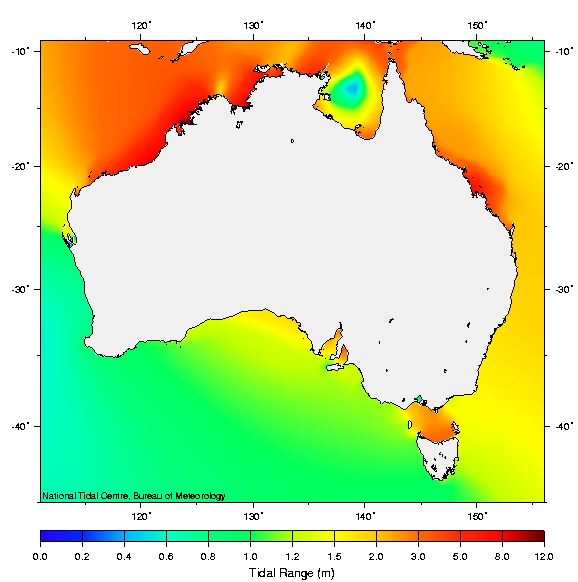
Image: Average tidal range at spring tides around Australia
This variation is due to the response of the ocean to astronomical tidal forces, and the shape and depth of ocean basins, bays, and estuaries, which can have a funnelling effect. The spread of tides around the oceans can be thought of as many waves interacting with each other as well as the topography of the sea floor, with waves undergoing reflection, refraction, rotation and changes of speed.
Large tides are observed in northwest Australia, in part because the large width of the continental shelf allows tides to grow larger than they otherwise would if it were a different shape. A similar effect occurs within the southern part of the Great Barrier Reef. Tides are also amplified as they spread into the South Australian gulfs and from either side of Bass Strait.
Another factor that influences tidal range is the presence of 'amphidromic points'. These points (or nodes) generally occur in the centre of ocean basins where there is almost no vertical movement from tidal action (a 'zero' amplitude in the tidal wave). The high tide wave crests and low tide wave troughs move around the points in a rotational pattern, generally (but not always) clockwise in the southern hemisphere and counter-clockwise in the northern hemisphere.
Areas close to an amphidromic point (such as southwest Australia) generally experience a smaller tidal range, while areas further away from one have a larger tidal range. The small-tidal-range 'bullseye' in the Gulf of Carpentaria in the map above is an amphidromic point.
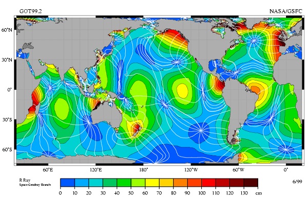
Image: Amphidromic points (in dark blue) that influence the nearby tidal range, for the M2 tidal constituent across the globe. Credit: NASA
Where are the largest and smallest tidal ranges in Australia?
Of Australia's major ports, the largest tidal range can be found in Derby, Western Australia. At its most extreme during 2018, the predicted tides range from 0.36 m at low tide to 11.78 m at high tide—a difference of 11.42 m (expected on 18 April).
The highest tide in the world occurs in Canada's Fundy Bay where the tidal range is up to 16.3 m at some times of the year.

Image: Tide heights and times for Derby, Western Australia on 18–20 April 2018, from the tide prediction pages on our website.
It is difficult to name Australia's smallest tidal range. In some locations, there can be little or no difference between successive high and low tides at certain times of the year (a 'zero' tidal range). In 2018, both Nornalup Inlet and Mandurah in Western Australia will have many instances of a zero difference between successive high and low waters.
Worldwide the smallest tidal ranges are found in the open ocean, along open ocean coastlines, and partially enclosed seas (such as the Mediterranean).
More information
- Check our tide portal for tide heights and times at your location.
- Explainer: king tides
- Going with the flow: Why it pays to check the tides before heading for your favourite rock fishing spot
- How the sun, moon and a massive continental shelf create Australia's biggest tides

Subscribe to this blog to receive an email alert when new articles are published.
Comment. Tell us what you think of this article.
Share. Tell others.