
Eyeing up a new generation of forecasting in Queensland
30 April 2014
Queenslanders can now view a detailed picture of the coming week’s weather anywhere in the Sunshine State, with this month's rollout of the Bureau’s powerful seven-day forecasting tool, MetEye.
The sophisticated online tool enables users to select a specific weather element and then zoom in to a particular location to see how this aspect of the weather is evolving – or is likely to develop in any three-hour period over the coming week.
The statewide coverage gives Queenslanders access to some of the most advanced weather forecasting in the world – with data captured in 6x6km grid cells across the state, and up to 60 nautical miles offshore.
As well as more detailed forecasts, MetEye provides specific data for individual users: enabling farmers to gauge the likelihood of rain on particular days, sailors to chart variable wind-speeds along their passage, and ordinary citizens to ‘speed-check’ the forecast in up to five favourite locations.
Build your own forecast
MetEye’s innovative features means that Queenslanders can now explore forecasts for specific weather elements that affect their lives. Whether it’s morning fog, afternoon rain, or the prospect of longer-term flooding, MetEye’s local views enable you to better plan your week – or make contingencies for more extreme circumstances.
As well as tracking weather elements on its interactive map, MetEye provides access to real-time rain radar, satellite cloud images, and playable ‘animations’ of unfolding weather events. You can also flick instantly to a seven-day text forecast for your location – enabling you to make weather-related decisions on the run.
With real-time data correlated from more than a 100 weather stations across Queensland, together with the Bureau’s extensive rain radar network and satellite images, MetEye is a one-stop link to the state’s most comprehensive weather information.
Covering land and sea
Mariners will take comfort from the offshore wind speed data and wave heights, as well as detailed labelling of coastal headlands, bays, islands and river entrances – all helping you plan your passage with greater confidence.
For busy landlubbers, MetEye provides a simple but highly effective planning tool, enabling you to search for the specific locations of a road trip, a weather-prone job, or a trip to the beach – and to know precisely what activities will be possible at different times of the day. And MetEye’s real-time river level ratings are likely to prove a useful feature in times of flood.
The MetEye rollout represents the completion of a statewide forecasting revolution that began last October, when the number of Queensland locations receiving seven-day forecasts increased from three to 67. Next on the agenda is the Northern Territory, where the service is expected to go live by the end of 2014.
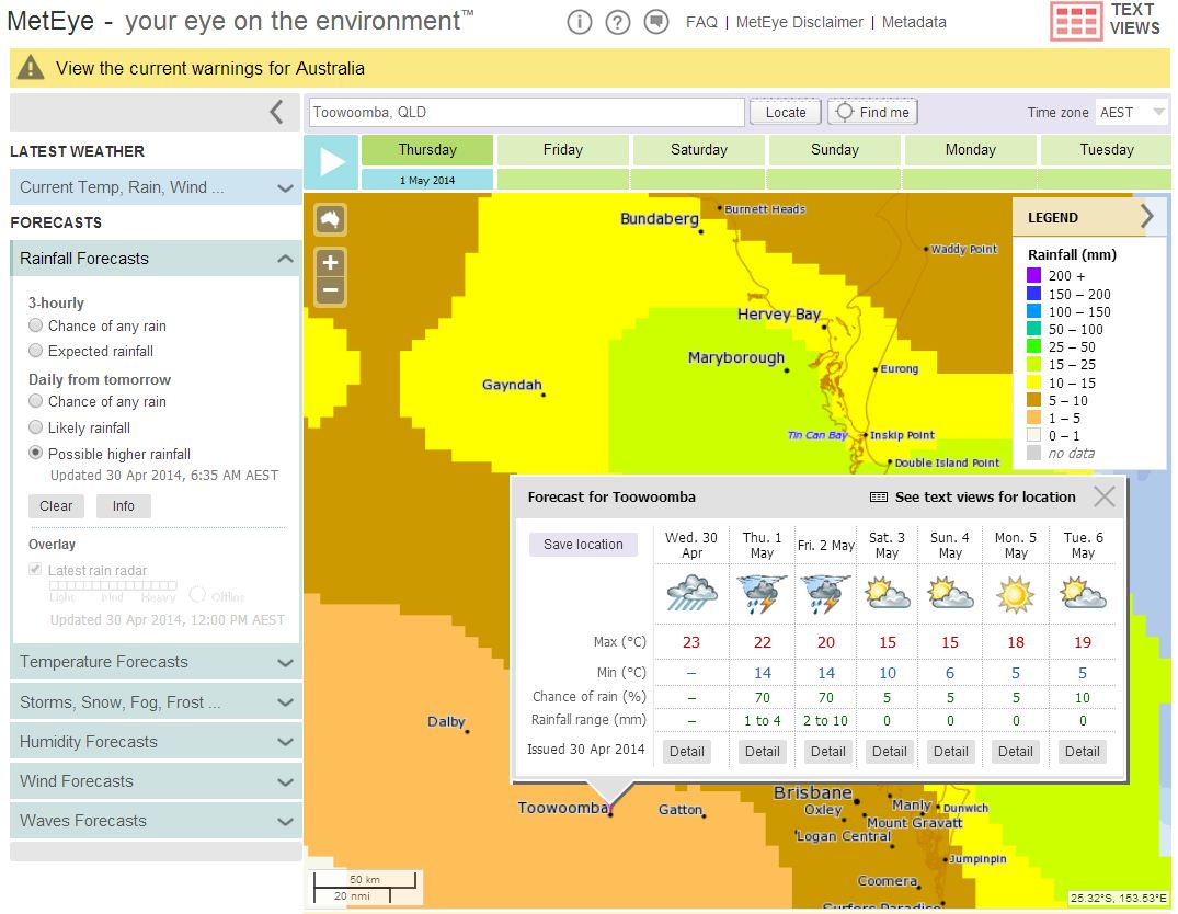
Example of a MetEye rainfall forecast for Toowoomba
MetEye is part of the Bureau’s Next Generation Forecast and Warning System (NexGenFWS), a high-resolution digital forecasting system first introduced in Victoria in late 2008. Since work began, NexGenFWS has received a number of prestigious project, technology, spatial, risk and information delivery awards.
On April 8th, the Bureau was awarded the annual Asia-Pacific Spatial Excellence Award for Technical Excellence, as well as the J K Barrie Award – the peak award for the spatial industry in our region.
Comment. Tell us what you think of this article.
Share. Tell others.