

Why are temperatures in the tropics so stable?
12 November 2018
It's often joked that weather forecasters in tropical regions have it easy, with temperatures rarely changing by more than a few degrees day to day. But why do temperatures in the northern Australian tropics vary so little while temperatures in southern states can change by upwards of 10 °C in only a day?
The answer essentially comes down to how hard it is for an air mass to change in the tropics. An air mass is a large volume of air that is characterised by uniform temperature and humidity. This uniformity is key to explaining the consistent temperatures in tropical northern Australia.
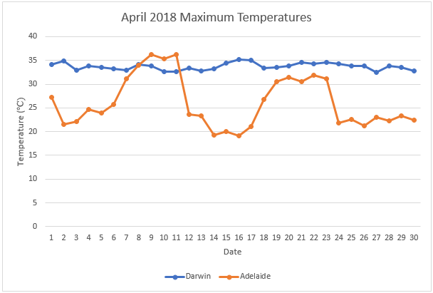
Graph: The maximum temperatures in Darwin and Adelaide in April 2018, showing how Darwin's is far more stable than Adelaide's.
A front-free zone
In southern states regular changes in air mass occur when frontal systems (such as cold fronts) move through, causing big changes in wind direction and speed. The systems can cause winds to change from northerly (from warmer northern Australia) to southerly (from the Southern Ocean and Antarctica) in only a few hours. This can see the air mass change rapidly from hot and dry to cold and moist.
In contrast, in the tropics the lack of frontal systems means air-mass changes happen much less frequently—we often have the same prevailing winds for months at a time.
Persistent winds (northwesterly during the monsoon and southeasterly during the dry season), ensure we remain in a similar air mass for prolonged periods. This means that variations in temperature are primarily due to the changes in cloud cover, rainfall and humidity. With the exception of significant rainfall events, like an active monsoon, the effects are only a few degrees and likely to be short lived, with conditions soon returning to average.
Sea breezes bring no relief
In southern states, afternoon sea breezes can drop temperatures considerably in a short period of time—so why not in the tropics? The answer comes from the relatively small contrast between land and sea surface temperatures in the tropics. The sun remains relatively close to the equator throughout the year and water retains heat much better than air. Across most of the wet season, sea surface temperatures around the Top End and Australia's northern coast remain in excess of 30 °C, whereas Melbourne's water temperatures struggle to exceed 20 °C, even in the summer months. So even on days with a sea breeze, there is little change to air temperature and any cooling effect of the sea breeze is limited to the afternoon and evening, before the temperatures climb again the following day.

Image: In northern Australia, sea breezes are relatively warm so don't cool the air temperature by much. Credit: Nicholas Loveday
So what does change the temperature?
Do we ever see significant air-mass changes in the tropics? Fortunately for lovers of the dry season, we do! Between May and September, strong high pressure systems in the Great Australian Bight direct southeasterly surges through Western Australia’s north and the Northern Territory, sometimes extending all the way to Darwin and the coast. These southeasterly surges bring a cool and dry air mass from the Southern Ocean and are responsible for the wonderful dry-season days and cool nights that provide respite from the heat. These southeast surges weaken as the high pressure systems move away, allowing the warmer and moister air mass to return across the Top End.
Just a few degrees can make quite a difference
Although significant air-mass changes are generally required for large temperature variations, it is important not to underestimate more subtle changes which can influence temperatures in the tropics. Those in the Northern Territory can attest that a November build-up day of 32 °C feels quite different from a build-up day of 35 °C—or that a dry-season night of 19 °C feels much cooler than a night of 22 °C. These differences can be created by changes in variables such as wind direction, sea-breeze timing, moisture, rainfall or cloud cover. So while the temperature may only change by a few degrees, that's not necessarily an indication of people feeling the same from one day to the next.

Subscribe to this blog to receive an email alert when new articles are published.
Comment. Tell us what you think of this article.
Share. Tell others.