
AskBOM: what is the monsoon?
22 January 2019
Hot, sticky and uncomfortable: the lead-up to Australia's monsoon season is usually the time northerners tend to go a bit 'troppo'! So, what is the monsoon, how does it bring relief to those in the north, and how does it affect the rest of Australia?
The word 'monsoon' comes from an Arabic word meaning 'season'. When we talk about monsoons we're generally referring to a seasonal wind that generates widespread, persistent rainfall across a broad region. There are monsoonal regions across most of the world's tropical areas, including northern Australia.
Australia's northern wet season extends from about October to April in the far north of the Northern Territory, but generally starts later and ends earlier elsewhere. Active monsoon periods may occur at any time during this period, however the initial monsoon onset, as defined by the reversal of the winds, normally occurs in late December around Darwin.
When an active monsoon arrives the sky is filled with dark clouds and we see widespread rain showers and thunderstorms. These can last for a few days or even a week or more.
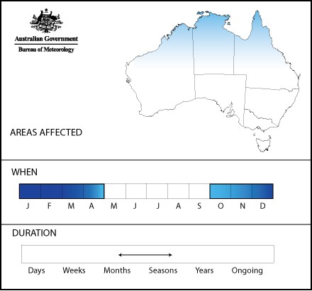
Diagram: the area affected by the monsoon, when it occurs and how long it may last.
What causes the monsoon?
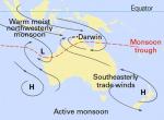
The Australian monsoon develops in response to summertime heating over the northern Australian region, when the continent warms at a faster rate than the surrounding oceans. This sets up a giant sea breeze circulation, drawing in moisture from these oceans over the lower pressure on the land. As the humidity progressively builds, a monsoon trough (which is the focus for the rainfall and cloudiness) becomes established over the Australian region. True monsoonal flow, with deep low-level westerly winds, exists north of the trough, so when the trough moves south over a location, this area becomes affected by monsoonal conditions.
An active monsoon period can be followed by an inactive or 'break' monsoon period, when we return to pre-monsoon or build-up type weather conditions—dominated by isolated showers and thunderstorms. Northern Australia typically sees about three monsoon bursts each wet season, sometimes occurring as late as mid-April. The end of the final monsoon burst of the year is called the 'monsoon retreat'.

Diagram: synoptic patterns typically associated with the active phase of the monsoon. The dashed red line indicates the position of the monsoon trough, which will shift slightly as weather systems progress across the continent. The monsoon trough is an area of low pressure along which broad-scale convergence and convection occurs.
Relief at last
Before the onset of the much-anticipated monsoon, northerners endure the so-called build-up—a time when they're said to go a bit 'troppo' due to the extreme heat and humidity.
The cooling, refreshing rains of the monsoon provide welcome change from the build-up and herald the annual transformation from a dry, brown landscape to a lush, watery oasis. It's these monsoonal rains that deliver the vast majority of the annual rainfall across most of tropical northern Australia. Farmers, communities and the ecosystems which have evolved across Australia's north depend on these monsoonal rains to replenish water storages and recharge natural aquifers. These rains can also create substantial flooding and restrict movement across large areas.
Climate factors such as whether it is El Niño or La Niña can have a significant impact on monsoonal variability. La Niña typically means earlier-than-normal monsoon onset, while El Niño is often associated with rainfall during the monsoon season being less than average. Another important climate driver is the Madden–Julian Oscillation or MJO. It can be an important influence on the timing of the active and inactive monsoon phases.
Bringing tropical moisture to the south
We're often asked how the monsoon affects the rest of Australia. During extended monsoon bursts, massive amounts of moisture build up throughout the atmosphere of northern Australia. Under the right conditions, weather systems across southern Australia tap into this tropical moisture—meaning high humidity, showers and thunderstorms, often leading to widespread rainfall and even flooding across the region.
But for northern Australia, the life cycle of the people and the environment is intimately related to the annual monsoon.
Further information
The Weekly Rainfall Update provides a commentary on the rainfall across Australia in the past week. It includes recent rainfall data and maps. You can subscribe to receive this by email.
Northern Territory Forecasts will indicate if the monsoon is in, or is approaching an active phase.
The Weekly Tropical Climate Note provides a technical explanation of the current state of the El Niño–Southern Oscillation (ENSO) and the MJO, both of which can affect the start of the monsoon and its variability. You can subscribe to receive this by email.
The wet and the dry: seasons in the tropics

Subscribe to this blog to receive an email alert when new articles are published.
Comment. Tell us what you think of this article.
Share. Tell others.