
Queensland floods: the water journey to Kati Thanda-Lake Eyre
19 March 2019
Updated 26 September 2019
Huge downpours of rain brought devastating floods to parts of northern Queensland and the Northern Territory early in 2019. This water made a slow and torturous journey south, filling the Georgina, Diamantina and Warburton rivers and flooding desert towns as it travelled. A second rain system in late March brought more water, extending across vast flood plains and eventually flowing into Kati Thanda-Lake Eyre many weeks after it fell, bringing life and colour to this dry country. So how and why did the water end up in Australia's largest lake?
Video: Watch this short video to experience the rare sight of Kati Thanda-Lake Eyre's vast waters.
January/February rain
In late January and early February, an intense and slow-moving monsoonal low over northern Queensland caused record-breaking rainfall and disastrous flooding. Areas affected included the Townsville region and westwards right across the state.
A phenomenal amount of rain fell. In the seven days to 4 February 2019 our rainfall gauge at Townsville Aero recorded 1052.8 mm, and 1257 mm in the ten days to 6 February. There were several sites in elevated areas including Paluma, Woolshed, and Upper Bluewater that reported 12-day accumulations of more than 2000 mm.
Further west, large areas recorded 300–500 mm including the northern parts of the Diamantina catchment—and it was this water that made the long journey south.
Video: This short video looks back at the Queensland floods
Ex-tropical cyclone Trevor rain (March)
In March ex-tropical cyclone Trevor brought more rain, over a broad region of central and southwest Queensland and adjacent area of the Northern Territory. In the week to 30 March, widespread rainfall of 50 mm to more than 200 mm was recorded across parts of the the Georgina/Eyre Creek, Diamantina and Thomson/Barcoo/Cooper catchments in the Northern Territory and Queensland. It caused significant flows in these rivers.
Where the water goes
Australia is divided into drainage divisions and river regions based on topography. Most of the drainage divisions affected by the January/February floods (such as around Townsville) empty out into the sea, with the exception being the Lake Eyre Basin—the lowest natural point in the country.
Animation: Topographic Drainage Divisions and River Regions
Diamantina catchment
The vast Diamantina River catchment is in southwest Queensland and covers an area of approximately 119 000 sq km. The river passes through the town of Birdsville before crossing the Queensland–South Australia border 10 km south of Birdsville. From there the water moves into the Goyder Lagoon and flows into the Warburton River for the final 150 km to Kati Thanda-Lake Eyre. The distance the water covers is longer than that though, due to the winding of the river system.
By the end of February, floodwaters captured by the Diamantina had been steadily moving downstream into the northeast of South Australia with flooding across vast areas of flood plain. On 22 February the Diamantina River gauge at Birdsville peaked at
8.15 m, surpassing the peak river heights of significant floods in 1999, 2000 and 2009—but falling short of the major flood of 1974 where it peaked at 9.45 m.
By late March, the water had receded in the Diamantina between Birdsville and the Goyder Lagoon, and the vast flood plain was 'greening', following the inundation of the preceding weeks.
However, there was more water to come. Rainfall from ex-tropical cyclone Trevor brought a 'second wave'. The water level at Birdsville measured 2.4 m on 18 April and rose steadily to peak at 7.7 m on 29 April.
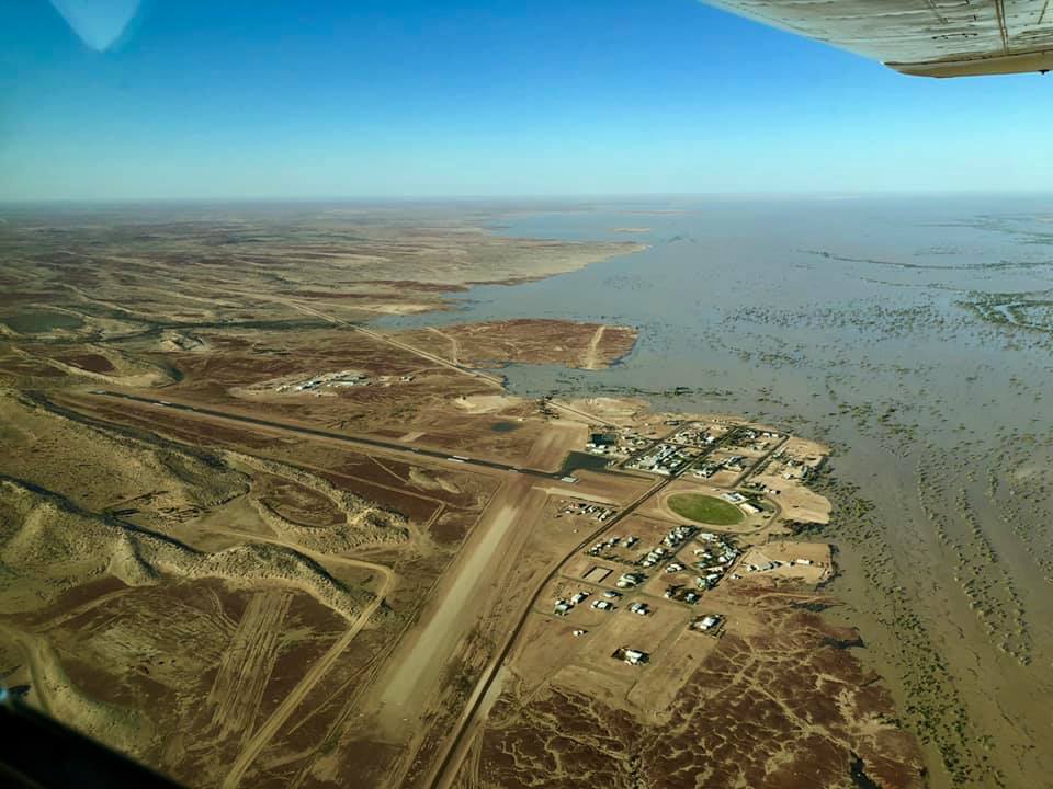
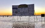
Photo: Birdsville, Queensland, in flood, February 2019. Credit: Birdsville Bakery
Georgina River and Eyre Creek catchment
This catchment drains an area of over 200 000 sq km. It rises to the northwest of Mt Isa with three main tributaries, the Buckley, James and Ranken rivers. Further inflow enters the system from numerous creeks and rivers, the two main tributaries being the Burke and Hamilton rivers. The Burke River drains the area to the north of Boulia and enters the Georgina River about 20 km upstream of Marion Downs, while the Hamilton rises to the northeast of Boulia and enters the Georgina River below Marion Downs.
The final gauge for this river system is at Glengyle Station. From there it's over 300 km (as the crow flies) to the Goyder Lagoon.
The January/February rain resulted in water level at Glengyle reaching about 3.5 m in the latter part of February. However, water didn't progress far past Glengyle. The rain from ex-tropical cyclone Trevor was much more significant here with the water level reaching 4.9 m early in March. The flow then tracked through the dry desert areas, finally reaching the Goyder Lagoon in early May.
Lake Eyre Basin
Floodwaters drained through the Goyder Lagoon, part of the Lake Eyre Basin. Water flows from the lagoon into the Warburton River on its way to Kati Thanda-Lake Eyre—one of the largest saltwater lakes in the world.
The Lake Eyre Basin region covers approximately 1.2 million sq km of arid and semi-arid central Australia. That's 17 per cent of the continent—nearly five times the size of the UK! It stretches, north to south, from just below Mount Isa in Queensland to Marree in South Australia. From west to east, it extends from Alice Springs in the Northern Territory to Longreach and Blackall in central Queensland. This is the world’s largest internally draining system.
Also Australia's largest lake, Kati Thanda-Lake Eyre covers an area of approximately 9500 sq km—however it's rare for the lake to completely fill. When the lake is full, it has the same salinity level as the sea, but as it dries up and the water evaporates, salinity increases.

Map: Lake Eyre Basin
Water from January/February rain
By 5 March, the Warburton River gauge at Poothapoota in South Australia (just downstream of the Goyder Lagoon) gave the first indication that the floodwaters were moving through, with the water level jumping 0.8 m in about 30 minutes and continuing to rise rapidly. It peaked at 5.7 m on 12 March.
The first flows into Kati Thanda-Lake Eyre were on 15 March.
Water from ex-tropical cyclone Trevor rain (March)
Water from the Diamantina River moved through the Goyder Lagoon while water from Eyre Creek also contributed to flow downstream of the lagoon.
The water level at Poothapoota downstream of the Goyder Lagoon peaked at 5.4 m on 20 May.
How full was the lake?
In early July satellite images showed around 80 per cent of the lake covered, though assessing the fullness of the lake (in terms of capacity) is difficult. This was about the maximum extent of the water and the most extensive cover since 2011. In subsequent weeks and months the water cover fluctuated daily with the winds, and slowly reduced due to evaporation. In the deeper parts some water may remain until early summer but the lake will be largely dry after that. Our forecasters will keep watching for the next inflows, whether that happens soon or a number of years down the track.
Animation: Floodwaters moving from Queensland to Kati Thanda-Lake Eyre, 14 February—14 July 2019 (colours enhanced for visibility). Source: Himawari satellite, Japan Meteorological Agency
A 'green lining'
While Kati Thanda-Lake Eyre didn't completely fill, this amount of water creates a desert oasis for a variety of birdlife, which breed on its islands and shoreline.
The floodplains of the Diamantina River and other channels in central Australia are also rejuvenated after years of drought.
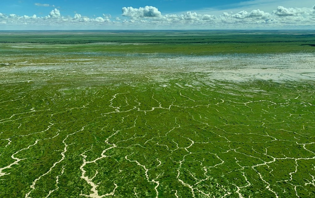
Image: Goyder Lagoon in the Lake Eyre Basin, May 2019. Credit: Matt Harnetty
While the floodwaters are good news for some, it's hard to forget the devastation caused by the heavy rainfall and floods in northern Queensland, where homes were lost and much of the state's cattle industry wiped out.
Our thoughts are with all those affected by these devastating floods, or involved in supporting recovery and reconstruction efforts—a long process.
More information
This article was originally published on 19 March 2019 and progressively updated as events unfolded. Its final update was 26 September 2019.
Flows into Kati Thanda–Lake Eyre Autumn 2019
Explainer: what are flash floods?


Comment. Tell us what you think of this article.
Share. Tell others.