

Record-breaking winds: remembering cyclone Vance
22 March 2019
It's 20 years ago today that severe tropical cyclone Vance tore across Western Australia's Pilbara coast near Exmouth. Vance still holds the record for the highest wind gust ever recorded on the Australian mainland. So how did this storm evolve from humble beginnings in the Timor Sea near Darwin to become one of Australia's most powerful cyclones?
On 22 March, 1999 the residents of Exmouth felt the full fury of severe tropical cyclone Vance. Our anemometer at nearby RAAF Learmonth recorded a peak wind gust of 267 km/h shortly before midday as the cyclone passed down the Exmouth Gulf, about 25 km east of Exmouth. That record still stands, 20 years (and many cyclones) on.
Animation: The path of cyclone Vance in March 1999.
Spinning up over the sea
Vance was first identified as a tropical low on 16 March in the Timor Sea. The warm sea surface temperatures and weak vertical wind shear (winds changing speed with height) in the region were ideal conditions for it to intensify. The low started to deepen and eventually reached tropical cyclone strength on 18 March—at which point it was named.
Moving in a west-southwesterly direction, Vance stayed in warm ocean waters off the Kimberley coast (and in a weak wind-shear environment). These conditions allowed it to continue to increase in strength and it became a category 3 severe tropical cyclone late on 19 March.
Vance continued its west-southwesterly track over the next 24 hours, gradually becoming stronger, and overnight on 20 March it became a category 5 severe tropical cyclone—the highest category in the Bureau's rating system.
Land impacts: wind, rain, flood and storm surge
At this stage Vance was still some distance from the coast, and there was no immediate threat to the mainland—but our Tropical Cyclone Warning Centre in Perth was concerned about the possible track of the system. They issued the first cyclone warning for the Exmouth/Onslow area at 10 am.
Late on the 21 March Vance started moving in a more southerly direction, towards the Exmouth/Onslow region, putting the area under direct threat. Onslow's 840 residents were asked to evacuate to shelters in Karratha.
During the morning of the 22 March, the eye of Vance passed across Exmouth Gulf, approximately 25 km to the east of Exmouth. The system then moved further inland and started to weaken.
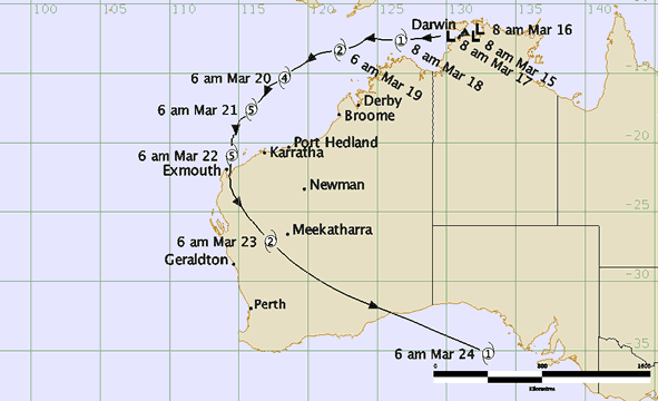
Map: Vance's track, from the Tmor Sea to the Great Australian Bight
By 23 March, Vance was near the town of Mt Magnet and moving in a southeasterly direction as a category 2 cyclone. This meant the winds were still strong enough to cause damage to properties at Cue when they struck at about 4 am.
Vance was downgraded to category 1 as it passed to the northeast of Kalgoorlie around 3 pm, but rain associated with the system was still heavy enough to cause flooding in the southern Goldfields, and the main highway and rail link to the eastern States were both cut by floodwaters.
Vance was still a category 1 cyclone when it crossed the Eucla coast during 24 March and the remnants of the system produced gale-force winds over parts of South Australia and Victoria.
Vance's destructive winds gave Exmouth a hammering: approximately 10 per cent of its buildings suffered severe structural damage and many more were further damaged by rainwater.
The cyclone generated a storm surge which left three large barges stranded on the edge of Beadon Creek, while the combination of very high seas and high tides caused an estimated storm surge of more than 5 m on the coast west of Onslow. Severe coastal erosion and widespread destruction of vegetation completely transformed the landscape.
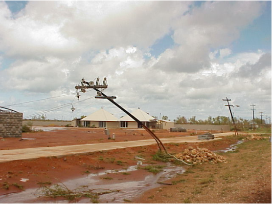
Image: Bent steel power poles, Exmouth. Credit: Barry Hanstrum
More information
Understanding tropical cyclone categories (short video)
Understanding tropical cyclone forecast track maps (short video)
How do tropical cyclones get their names?
Tropical cyclones: just for the tropics?


Comment. Tell us what you think of this article.
Share. Tell others.