

Meet the locals: when the weather gives the place character
03 May 2019
Updated 25 August 2021
Love ‘em or loathe ‘em, Australia’s local weather phenomena can be a defining feature of a city, town or region. From the sweet relief of the Fremantle Doctor taking the edge off Perth’s heat to the blustery southerly buster that can blast cool changes up along the New South Wales coast, find out about some of our best-known local weather ‘characters’.
Much weather is variable and complex but some kinds of weather happen regularly in particular places when certain conditions line up. This is because they are influenced by local geography, such as the position of hills, valleys and proximity to the sea. They can also be affected by factors that change regularly with the seasons in that location, such as air temperatures and the level of moisture in the atmosphere.
Fremantle Doctor
The Fremantle Doctor is a local term given to the afternoon sea breeze that affects the Perth region. In Perth, hot days are usually associated with dry easterly winds during summer and early autumn months, beginning during the morning and continuing into the afternoon. The Doctor is just the tonic as it brings with it much cooler temperatures as it spreads inland from the coastal fringe through to the Darling Scarp. In almost all instances it arrives from a southwesterly direction during the late afternoon, with locals rejoicing that the heat of the day is over.
Gulf lines
Gulf lines are lines of showers that move from east to west across the Gulf of Carpentaria. They can occur even during northern Australia's dry season (May to September). They typically form over far north Queensland with the afternoon sea breeze.
Captured by the prevailing easterly winds, these showers form into north–south oriented lines and travel across the Gulf of Carpentaria overnight. Often these showers will reach the northeast Top End of the Northern Territory the following morning. They're a common source of intermittent rain for northeast Arnhem Land during the dry season.
During monsoon-break periods in the wet season (October to April), when the winds are also easterly, gulf lines can grow into thunderstorms. Gulf lines affecting northeast Top End communities in the morning may continue moving west through the day. The following morning they can produce an early morning thunderstorm in northwest Top End communities, including Darwin. Sometimes gulf lines will continue moving west and affect Timor.
Gulf lines can also help form severe squall lines during the wet season. Squall lines are a group of storms arranged in a line that often produce squally conditions – strong winds and heavy rain.
.jpg)
Image: Gulf lines in Nhulunbuy, Northern Territory. Credit: Cameron Hines
West coast trough
During summer people in the west of Western Australia often hear the phrase 'the trough is moving inland', or 'the trough is off the coast' in weather reports. So what is this referring to?
The answer is a feature known as the west coast trough. This is the main influence on the weather conditions along the west coast of the state during summer.
The trough is a boundary between hot air to the east of the coastal fringe and cooler air to the west. It moves from the west of the coast to inland over a regularly repeating period of around 4–6 days.
The cycle begins with a high pressure system moving to the south of the state, allowing easterly winds to blow into the west coast for 3–4 days.
Initially the winds come from the southeast. As the high drifts further eastwards the winds slowly swing to the east and eventually to the northeast. The high drags increasingly hotter air into coastal areas as it moves. These northeasterly winds are responsible for the hottest temperatures of summer. If the trough remains offshore then northeasterly winds blow consistently. This can cause heatwave conditions.
The cycle ends around days 5–6, when the trough moves inland due to interactions with frontal systems well to the southwest of the state. Winds blow from the west, bringing much cooler and sometimes very humid conditions to coastal areas. The first day or two after the trough passage can often see very strong sea breezes.
The west coast trough is usually associated with fine weather. But thunderstorms can occur to the east if there's enough moisture in the atmosphere. If tropical systems interact with the trough then there can be heavy rain.
Ekka winds
The Royal Queensland Show is affectionately known as the Ekka. It's been abbreviated over the years from its original name, the Brisbane Exhibition. Brisbane locals know when the Ekka rolls around in August that chilly westerlies will also likely roll through the city.
The northward migration of high pressure cells in winter causes a swing in the prevailing wind. West to southwesterlies become more common in Brisbane from June through to late September.
The Brisbane area generally sees the strong west to southwesterlies during these months. The Ekka winds can whip up dusty conditions for the big crowds at the showgrounds, located in Bowen Hills.
In August, Brisbane has a mean rainfall of 36.2 mm, maximum mean temperature of 23.4 °C, and mean wind speed (at 9 am) of 8.5 km/h. The wind comes from a southwesterly direction for about 60 per cent of the time for that month. While the mean minimum temperature for Brisbane in August is 10.8 °C, it can feel much colder, particularly in strong and gusty winds. For example, for a temperature of 10 °C and wind speeds of 20 km/h, the apparent ('feels like') temperature would be about 5 °C.
So remember to pack a jacket when the Ekka winds roll into Brisbane town!
Bridgewater Jerry
The Bridgewater Jerry is the local name for fog rolling down the Derwent River to Hobart, across the Tasman Bridge and further south. Generally an autumn or winter phenomenon, it occurs on cold clear nights when fog forms in the upper Derwent Valley and the Jordan Valley. These two valleys ‘join’ near Bridgewater (perhaps a reason for the name—although its exact origin is shrouded in 'mist-ery') with the fog appearing to flow down the river, trapped by the hills to the west and east. It may cause reduced visibility in places, but in reality it's a thing of beauty and much loved by locals!
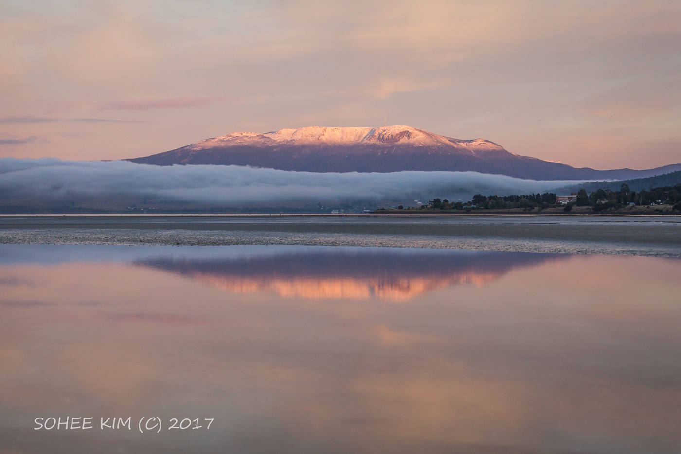
Image: Bridgewater Jerry, Tasmania, 13 August 2017. Credit: Sohee Kim
Hector ('the Convector')
A thunderstorm forms over the Tiwi Islands, just north of Darwin, almost every afternoon during the wet season (October–April). The formation of this thunderstorm is so regular it has a name: Hector. It was named by World War II pilots who used it for navigation. It's also known as 'Hector the Convector' (convection describes the way heat energy moves between hot and cool parcels of air in thunderstorms).
Hector forms most days due to the perfect collision of sea breezes interacting with the land mass of the Tiwi Islands, and can reach as high as 20 km into the atmosphere. It's not unusual for Hector to dump rainfall of more than 50 mm within a couple of hours during the wet season.
Video: Weird Weather: Hector the thunderstorm
Morning glory cloud
Morning glory, also known as a roll cloud, is a jaw-dropping phenomenon that generally occurs early to mid-spring over northwest Queensland, most notably across the Gulf Country and the Gulf of Carpentaria. During the afternoon, sea breezes from the east and west coasts of Cape York collide over the peninsula and collapse back towards the surface. This creates a wave in the atmosphere like a ripple moving across a pond.
For conditions to be just right for these clouds, there needs to be an ‘inversion layer’ where temperature increases with height. Then moist air ascends and condenses into cloud along the leading edge of the westward-moving front, descending at the rear to form turbulent, cylinder-like waves. It reaches the southern gulf coast in the early morning as a spectacular roll cloud.
While roll clouds can occur anywhere given the right ingredients, the unique orientation of the peninsula and gulf coast mean that the morning glory can be reliably forecast and observed around Burketown and Normanton in the spring months. It can form a series of up to ten roll clouds, one after the other. The clouds can extend up to 1–2 km in height and, amazingly, can span up to 1000 km in length!
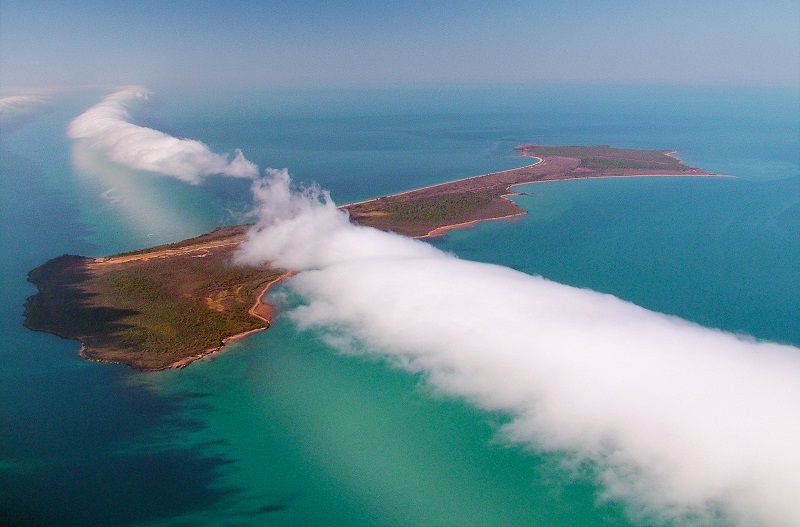
Image: Morning glory cloud above Sweers Island, Queensland, 23 August 2009. Credit: Tex Battle
Southerly buster
A 'southerly buster' is a term used to describe an abrupt southerly change that moves up the NSW coast. Other countries, such as New Zealand and Argentina, have southerly busters too. For the change to be labelled a 'southerly buster', southerly winds must exceed 29 knots (54 km/h) and a temperature drop of at least 5 °C must occur within three hours.
Southerly busters form when a cold front passes over southeast Australia, moving up the coast quickly compared to how it's moving inland, where it lags due to mountain ranges. Southerly busters are particularly felt because of the warm days preceding the front caused by hot west to north-westerly winds. This is comparably different to the cool, dense air change associated with the southerly buster.
Change days
Melbourne famously inspired the Crowded House song, 'Four Seasons in One Day', and it's 'change days' when you really experience this. A change day is simply a day when a cold front crosses the city. These days are most noticeable from late spring to early autumn, when the temperature difference between the Australian land mass and the Southern Ocean is at its greatest.
Northwesterly winds ahead of the front drag hot air from the interior of the continent over Melbourne, while the southwesterly winds following the front have been moving over the much colder Southern Ocean. This means that when the front moves through, temperatures drop rapidly as the wind changes direction. They can sometimes fall 15 °C or more in a matter of minutes. Once these fronts have rounded Cape Otway they often accelerate up the coast towards Melbourne and produce strong, squally winds. Thunderstorms can accompany the cold front, forming as the hot air ahead of the front is lifted by the cold air behind it. This means the weather can go from hot, to wet and humid, and then to cold in less than an hour!
Gully winds
The gully winds are a nocturnal strengthening of southeasterly winds down the leeward (western) slopes of the Mount Lofty Ranges and over Adelaide. They mainly occur in the summer and near-summer months, when there is a high pressure system to the south and winds are from the southeast. These winds are reinforced by the downslope acceleration of cooler air, which makes the gully winds gusty and can lead to them being stronger than the prevailing wind. Onset can be sudden and occurs in the evening as the southwesterly sea breeze ceases. In extreme cases, gully winds can cause severe turbulence at Adelaide Airport and damage trees and buildings.
Airport fog
Fog is a common feature of Canberra's morning weather during the cooler months. The peak fog season there runs May–July, with fog typically occurring at the airport on about 25% of days.
Most Canberra fogs are 'radiation fogs'. On calm, cloudless nights, heat radiates efficiently from the land out to space, so the temperature of the air near the land decreases. On long nights (such as in June), this radiative cooling often brings the air close to 100 per cent humidity, allowing water vapour in the air to condense and form cloud droplets. The cloud droplets immediately above the ground form fog.
Fog usually clears in the hours after sunrise, when the sun causes temperatures to rise and humidity to fall. As a result, the water droplets turn back into water vapour and the fog 'burns off'. Most fogs at Canberra airport clear by 9 am, but occasionally fogs can last longer than this.

Comment. Tell us what you think of this article.
Share. Tell others.