
Fire weather across northern Australia
20 August 2019
Anyone who has visited northern Australia during the dry season would be familiar with the dry, warm days and beautiful smoky, orange sunsets that grace the horizons each evening. However, the weather conditions that make our tropical landscape so picturesque also make it one of the most fire-prone environments in the world.
As the wet season begins to wrap up through April and May, the savannas (sparse trees with a grassy understorey) of northern Australia undergo a rapid transformation, and:
- storms and showers begin to disappear;
- the massive growth of plants and grasses from bucketloads of wet season rain, starts to slow and dry out;
- southeasterly wind surges begin to strengthen;
- dry continental air starts to replace the 'sultry' humid conditions left over from the wet season; and
- bushfires begin to appear.
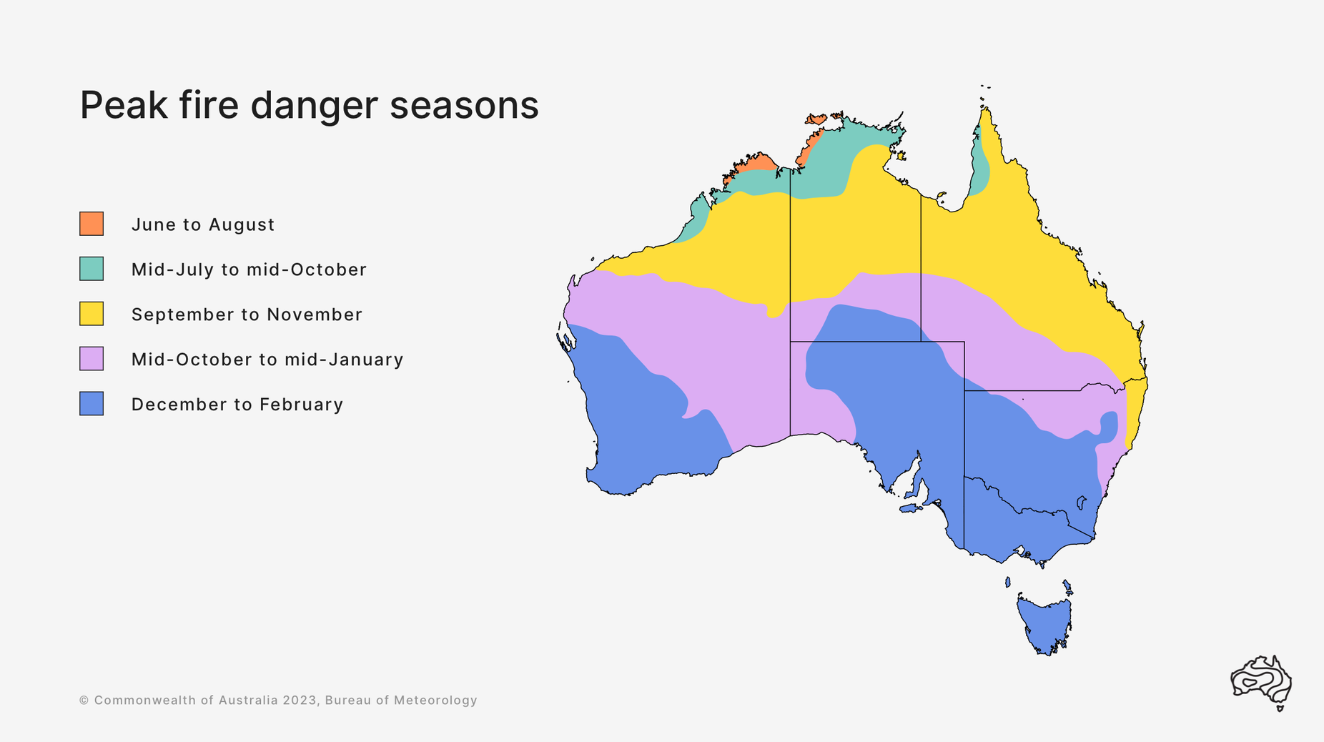
Map: Australia's bushfire seasons
If left unchecked, bushfires can cause damage to the environment, ecosystems and property, and are a risk to people's safety and livelihoods. Late in the dry season when grasses and vegetation are at their driest, strong, dry winds can lead to fires so intense that they are difficult to fight and control. In response, fire agencies, land managers and Traditional Owners put in a huge amount of effort early in the dry season, with prescribed burns to help manage the bushfire risk by strategically reducing fuel loads.
Most prescribed burning is based on traditional fire management practices. These were developed over thousands of years to manage the environment for food production and cultural obligations. 'Cool' fires are normally lit early in dry season when grass is not completely dry and in the evening when cooler temperatures and morning dew make the fires self-extinguishing. Cool fires don’t scorch the leaves of the trees but remove the more flammable grasses.
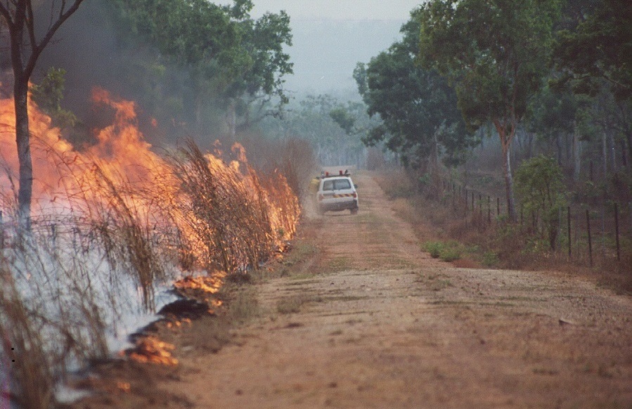
Image: controlled burns in the Northern Territory. Credit: Bushfires NT.
Assessing fire danger
The Bureau of Meteorology's meteorologists work closely with fire managers to provide Fire Danger Ratings. Fire Danger Ratings are based on the Grass Fire Danger Index (GFDI) which is derived from weather and fuel factors. Weather factors include wind strength, temperature and humidity, and fuel factors include dryness (known as 'curing') and quantity ('fuel load') of flammable vegetation.
Dangerous fire conditions require a combination of gusty winds, low humidity and warm temperatures in locations where the curing and fuel load are high. While the first three of these conditions can fluctuate wildly throughout a day, the key to forecasting fire danger is analysing when the worst of these conditions will align together and for how long. The fire danger ratings and GFDI are calculated for every hour of every day for locations throughout Northern Australia – refer to the Bureau's Fire Weather Services webpage.
Video: Watch this short video to learn more about fire weather.
When considering fire danger ratings in the tropics, the wind is the most important factor to forecast accurately. The wind speed has a direct impact on the intensity of a fire and is responsible for how quickly a fire can travel across the landscape. Furthermore, a change in wind direction can radically increase the area of a fire and is extremely dangerous to firefighters, who may be suddenly caught with the fire turning towards them as the wind changes.
Curing and fuel load
The curing and fuel load of vegetation is also very important and is highly dependent on the vegetation type and the time of year. In tropical grassland environments, 'curing' is the measure of how dry the fuel is and increases during the dry season, while the 'fuel load' estimates the dry weight of flammable fine fuel (grass) in tonnes per hectare (t/Ha) and is related to the amount of preceding rainfall and other factors such as grazing pressure.
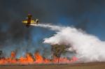
Grasslands in the more arid parts of central Australia generally have low fuel loads of less than 4 t/Ha (except in areas invaded by the exotic buffel grass), whereas in the tropics, average fuel load can reach 6 t/Ha due to the heavy grass growth associated with high wet season rainfall. Invasive species such as gamba grass, which is spreading rapidly in parts of Northern Australia, can cause fuel loads to exceed 10 or 15 t/Ha. In the Northern Territory for example, the greatest concentration of gamba grass occurs around Batchelor, 100 km south of Darwin, often resulting in the Territory's greatest fire danger ratings.

Image: water bomber over a fire at Batchelor, NT. Credit: Stephanie Bond
Forecasting fire weather
Every day, meteorologists at the Bureau forecast weather conditions for every hour over the coming seven days and identify at-risk areas and the times of highest fire danger. Changing weather conditions such as wind surges, sea breezes and the influence of terrain can exacerbate a fire situation.
The Bureau's forecasts greatly assist fire agencies and land managers to declare fire bans, allocate resources, and plan prescribed burns. Telephone briefings are provided directly to fire agencies, together with detailed forecasts for active fires, to equip fire managers with the most up-to-date information on the weather conditions.
What to do when there’s a risk of fire
If you live in or are travelling to an area that could be threatened by fire, you need to have a bushfire plan in place. On a day when dangerous bushfire activity is more likely, stay in touch with your local fire agency and emergency services via their websites and social media—and tune into emergency broadcasters.
More information
- Fire weather knowledge centre
- Fire weather warnings
- Current warnings
- Northern Territory property bushfire management and survival plans
- Northern Territory Fire Ban Advice
- Northern Territory Fire Incident Map


Comment. Tell us what you think of this article.
Share. Tell others.