Cold comforts: Smart forecasting tools for savvy skiers
05 June 2014
As Australia’s ski season gets underway on June 8th, our alpine resorts will be looking to Mother Nature to deliver the snow. But two new services from the Bureau of Meteorology will be ‘delivering the weather’ ahead of time.
Heading for the ski fields this winter? With the arrival of the Bureau’s brand new mobile website and our location-tracking MetEye service, it has never been easier to check the weather on the slopes.
For skiers chasing the best snow, the Bureau’s mobile weather website tells smartphone users how the weather will develop every three hours over the next 24 hours, in all the main alpine resorts in Victoria, New South Wales and Tasmania.
The new mobile service provides details of the local temperature, humidity, wind speed and direction, and rainfall or snow in clear at-a-glance table and graphical form. In sub-zero temperatures, the ‘Chance of any rain’ figure converts almost precisely from 1 mm of rain to 1 cm of fresh snow.
Mobile users can pre-set three favourite locations to give them instant access to the latest weather data from their three top resorts—or activate an in-browser GPS to check data from the nearest weather station once they are in the mountains.
Mapping your ski holiday
Skiers planning further ahead can go online to check the projected snowfalls over the next seven days at specific resorts and ski fields through the Bureau’s state-of-the-art map viewer, MetEye.
Once you arrive on the MetEye landing page, simply type your preferred resort or destination into the location dashboard at the top of the page and choose the location from the list.
The map will automatically resize and a pop-up window with the forecast for the next seven days will appear like this:
Inside this window, you’ll find a ‘See text views for location’ link (highlighted above in red), which will take you to a much more detailed view that includes current conditions and forecasts alongside radar and satellite images.
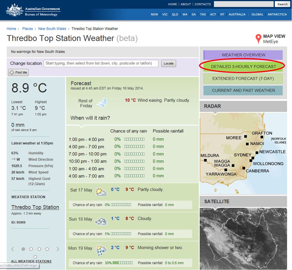
The next screen will look like this:

Actual weather (left panel) Forecast weather (middle panel) Radar and satellite (right panel)
Again in the top right hand corner there’s a link to the ‘Detailed 3-hourly forecast’, which will take you to a full breakdown of the local weather—including the wind chill (‘Feels like’) , current snow, and the chance of rain/snow.
The circles under ‘Significant Weather’ provide a quick and convenient way to check what time of day snow is forecast to fall—so you can time your trip to the slopes to perfection.
For a full picture of current snowfalls, you can also customise a radar map of your location by scrolling down to ‘Forecasts’ on the left side of the MetEye landing screen and selecting from the ‘Storms, Snow, Fog, Frost’ menu.
But please remember to check the forecasts regularly, as conditions can change rapidly in the Australian Alps.


Comment. Tell us what you think of this article.
Share. Tell others.