

Predicting fire-generated thunderstorms
02 March 2020
Fire-generated thunderstorms (also known as pyrocumulonimbus) are thunderstorms that develop in bushfire smoke plumes. They can cause rapid and unpredictable changes to fire intensity and spread due to intense downburst winds, enhanced ember showers, lightning (causing new fires) and even fire tornadoes—all of which are extremely hazardous to firefighters. Science is helping meteorologists to forecast them.
Meteorologists can forecast conventional thunderstorms but predicting fire-generated thunderstorms is a big challenge. A research team from the Bureau and the Bushfire and Natural Hazards Cooperative Research Centre has discovered how to 'diagnose' the minimum fire heat required for fire-thunderstorm development in a given environment, meaning substantial advances in our ability to forecast these dangerous storms.
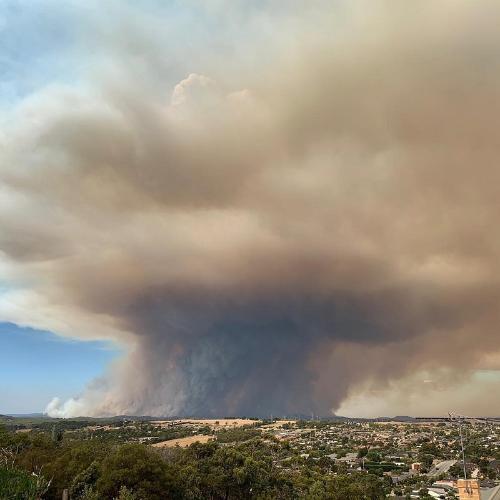
Image: A fire-generated thunderstorm in Bunyip, Victoria in 2019. Credit: CFA Media
How do thunderstorms—and fire-generated thunderstorms—form?
The formation of fire-generated thunderstorms has much in common with conventional thunderstorms, but in their case it's the fire driving the triggers and mechanisms rather than the usual interactions in the atmosphere and environment.
Most thunderstorms develop when warm humid air near the ground is forced upwards and rises rapidly in an unstable atmosphere. There is almost always a stable barrier of air between the warm humid air and the unstable layer above. An initial 'lifting' mechanism needs to force the warm humid air upwards through the stable barrier layer.
Importantly, the upper layer is only unstable to rising air parcels if the lower layer is sufficiently warm and humid, and the instability is only realised when clouds form in the lifted air above the stable barrier layer. This occurs when the heat produced by the condensation of water in the cloud makes it warmer and hence more buoyant than the surrounding clear air. This causes the cloud to billow upwards, producing the characteristic puffy, white, 'cauliflower' appearance.
The relative strength of each layer determines how favourable the atmosphere is for thunderstorm development. For example, a very warm and humid lower layer with a weak stable barrier and very unstable conditions above will highly favour severe thunderstorm development, because it won't take much lift to get the warm humid air past the barrier—and the high instability means there's abundant energy from condensation that can be released. On the other hand, if the lower layer is too cool and dry, the upper layer might not be unstable to air parcels lifted through the stable barrier, in which case no amount of lift will generate a thunderstorm.
Fire-generated thunderstorms are subject to the same process, however the fire drives some important variables that make conditions more favourable for thunderstorm development. The fire provides a boost to the lower-layer temperature and humidity (burning and combustion produce both heat and water vapour) while the buoyancy of the plume supplies the lift.
So, a sufficiently large and intense fire may boost the warm humid lower-layer air, providing buoyant lift to penetrate the stable barrier layer, while increasing the instability of the upper layer.
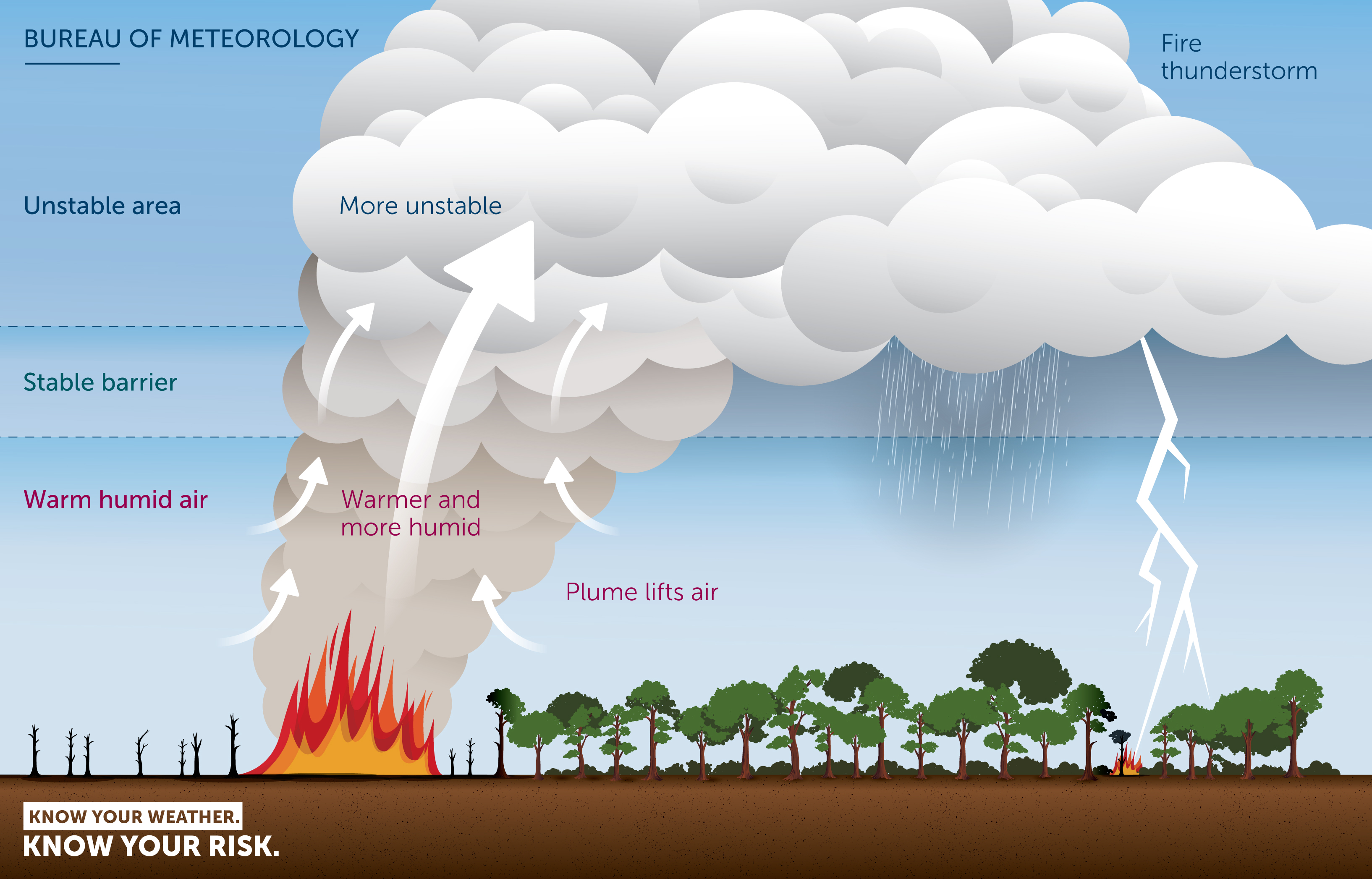
Diagram: In a fire-generated thunderstorm air is drawn into the plume where it gets warmer and more humid, which makes it more unstable when cloud forms after it rises through the stable barrier.
Thinking differently about the prediction challenge
Weather balloons, which measure how temperature and humidity change with height, provide meteorologists with a precise measure of the warm humid lower layer, the associated instability above and the strength and depth of the stable barrier. They use this information to make conventional thunderstorm forecasts. In contrast, it is difficult to anticipate the temperature and humidity boost a fire might provide, because the size, intensity or even presence of the fire is difficult to predict in advance, which makes fire-generated thunderstorm prediction a major challenge.
The research team used a reverse approach to the fire-generated thunderstorm prediction puzzle. Rather than try to anticipate the temperature and humidity boost the fire might provide, they found a way to identify the minimum height the plume must rise to and the minimum boost needed at that height for fire thunderstorms to form. Using these values, calculated from weather balloon or forecast model data, it's possible to assess how favourable the atmosphere is for fire-generated thunderstorm development.
The team also developed a method to determine the 'firepower' (the rate heat energy enters the smoke plume from the fire) required to deliver the minimum boost to the minimum height for a given wind speed. It is essential to consider the wind speed because the stronger the wind the more the plume bends over, which means the fire needs to produce even more heat for the plume to rise to the required height. Given that this 'firepower' is just sufficient to produce fire-generated thunderstorms, the team refers to it as the pyrocumulonimbus firepower threshold, or PFT.
The PFT is calculated from an equation that simplifies a very complex process, but nonetheless it has yielded very useful results.
Fire-weather forecasters and fire-behaviour analysts have known for decades that weather conditions that favour bushfire smoke plume development (warm and humid with light winds) don't favour large and intense fires (hot and dry with strong winds). The opposite is also true. For fire-generated thunderstorms to form, the mix of these conditions needs to be just right. The research team uses the ratio of the firepower threshold to a modified fire danger index to identify this mix—it's called the 'PFT-flag'. This helps signal where the mix of plume-friendly to fire-friendly weather is more likely to result in a fire thunderstorm.
Trialling fire-thunderstorm forecasts
Fire-weather forecasters in New South Wales and Queensland trialled PFT and PFT-flag forecasts during the spring fires of 2019. They found them very useful for predicting periods of high fire-generated thunderstorm threat several days in advance and for identifying meteorological phenomena (such as sea breezes, cold fronts and thunderstorm outflows) that trigger deep moist pyro-convection, leading to fire-generated thunderstorms. The forecasts helped alert meteorologists to the times and places where fire-generated thunderstorms were most likely, which could then be included in the specialised information they were providing to assist in fire-fighting. The trial has now been expanded all around Australia. Feedback from fire-weather forecasters and fire-behaviour analysts will help refine the methods used to make the forecasts and contribute to improved fire-generated thunderstorm forecasts in future seasons.
More information
When bushfires make their own weather
Predicting fire-generated thunderstorms
Weather and emergency management: behind the scenes at Victoria’s State Control Centre

Comment. Tell us what you think of this article.
Share. Tell others.