Weather Radar
27 April 2012
Monitoring high impact weather with weather radars is an important part of the Bureau of Meteorology's services to the Australian community. Our network of 60 radars across the country provides vital information to our forecasters, the general public and private industry about severe weather threats.
We mainly use radar for nowcasting – detailed weather forecasting over the next few hours covering a range of a few kilometres.
Strategic Radar Enhancement Project
The Strategic Radar Enhancement Project is a seven-year project with $48 million of Federal Government funding that will explore how radar can be used to improve extreme weather forecasting. The project involves:
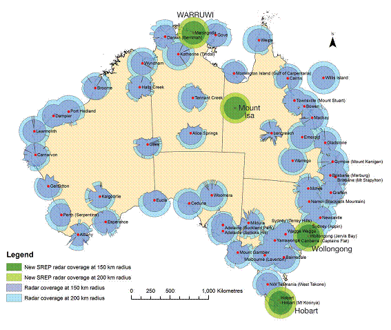
- installing four new radars in Wollongong (New South Wales), Hobart (Tasmania), North Central Coast (Northern Territory) and Mount Isa (Queensland), closing the gaps in the existing radar network shown in the map below;
- improving the nowcasting of rainfall through research and the development of a computer system that produces possible rain intensity scenarios. The system, known as STEPS (Short Term Ensemble Prediction System), allows us to produce forecasts that include the likelihood and amount of rain in a particular area;
- including radar data in Numerical Weather Prediction models and updating them more frequently. Numerical Weather Prediction has been the key to improved accuracy of weather forecasts around the world in the last decade. Our models provide excellent guidance on scales of over 12 km, but preliminary results show these new models will provide even better guidance at a higher resolution (1.5 km).
The project will allow the Bureau to provide better short-term forecasts for heavy rainfall. This will help the community plan and prepare for these events, minimising the effects of flash flooding.

New radars cover gaps in the existing radar network


Comment. Tell us what you think of this article.
Share. Tell others.