
Currents of change: Tracking the El Niño/La Niña cycle
19 June 2014
Updated 1 February 2019
An El Niño increases the likelihood of drier and warmer seasons in southern and eastern Australia—and of subsequent lower availability of water. This means the period leading up to one is 'decision time' for many individuals and industries. So how can you track the development of this complex natural phenomenon?
El Niño and its opposite phase, La Niña, are the result of periodic changes in the temperature of the tropical Pacific Ocean and interactions with the atmosphere above it, as part of a natural cycle known as the El Niño–Southern Oscillation. In the case of El Niño, these changes are associated with a warming of the central and eastern tropical Pacific Ocean, whereas La Niña events are a result of cooling in these same areas.
La Niña events can also have significant outcomes, with the ‘double-dip La Niña’ in 2010–12 causing widespread flooding over much of eastern Australia.
An early indication that an El Niño or La Niña could be developing can give those most susceptible to our variable climate time to prepare—potentially preventing or mitigating financial losses and other adverse consequences.
A continuum of change
An El Niño and its impacts don’t happen overnight; it’s not like flicking a switch. The transition from normal or ‘neutral’ conditions to El Niño should be considered more as a continuum. Changes happen gradually, usually over a period of several months, and can fluctuate back and forth over shorter time scales.
Collectively, this longer-term ‘see-sawing’ between El Niño, La Niña and neutral conditions is what meteorologists refer to as the El Niño–Southern Oscillation, or ENSO.
Climatologists, including those at the Bureau of Meteorology, monitor the oceans and atmosphere in the tropical Pacific regions for signs that the system might be shifting one way or another. At times temperature patterns in the tropical Pacific Ocean may vary away from their normal state. The atmosphere and ocean interact, at times reinforcing each other and creating a ‘feedback loop’, which can strengthen these small changes in the state of the ocean into an ENSO event.
When it is clear that the ocean and atmosphere are fully coupled—that is, they are mutually reinforcing each other—an ENSO event is considered established.
Tracking the ENSO cycle
The ENSO Outlook is based upon a comprehensive analysis by Bureau climatologists, including the survey of eight international climate models which predict changes in ocean temperatures in the central and eastern tropical Pacific Ocean.
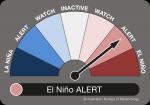
The ENSO Outlook classifies the current state of the ENSO cycle according to three alert stages (WATCH, ALERT and EL NIÑO/LA NIÑA). An online summary of its findings is updated every two weeks. Each of these stages indicate the level of development of an ENSO event—in other words, how far the overall state of the climate seems to be tipping towards either La Niña or El Niño.
If some oceanic or atmospheric indicators are showing values indicative of the early stages of an El Niño event, which in the past have gone on to exceed El Niño thresholds about 50 per cent of the time, an El Niño WATCH is issued. This means there is a 50 per cent chance that an El Niño will develop—usually in the winter to early spring months. There is also a 50 per cent chance, however, that these early signals are just shorter-term fluctuations, and the system will remain in a neutral state.
If these early El Niño signals continue to strengthen, and other indicators start to shift towards El Niño thresholds, an El Niño ALERT will be issued. In this stage, there is a 70 per cent chance that the system will go on to develop into an El Niño—although there remains a 30 per cent chance that conditions will stay neutral.
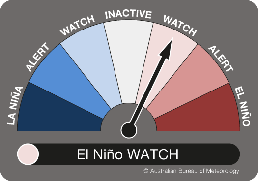
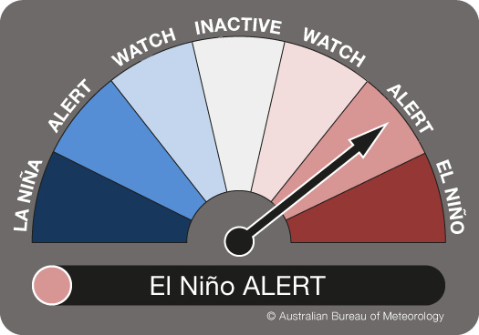
Diagram: ENSO Outlook indicating an El Niño WATCH (left) and El Niño ALERT (right)
Finally, when the system is fully coupled (both the atmosphere and ocean are reinforcing the El Niño state), an EL NIÑO, the final stage of the ENSO Outlook, will be declared.
When our climatologists deem that the El Niño has broken down and is no longer likely to impact upon Australian rainfall and temperature patterns, the ENSO Outlook will be returned to INACTIVE.
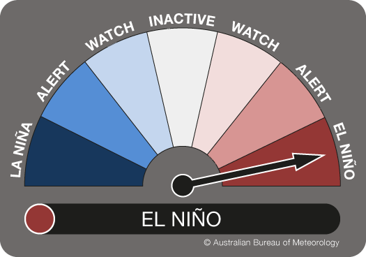
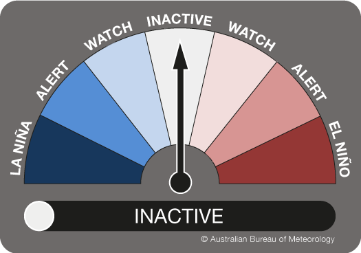
Diagram: ENSO Outlook indicating an El Niño event (left) and no impact with INACTIVE (right)
The ENSO Outlook provides a simple and convenient snapshot of the current status of ENSO, and the likelihood of an ENSO event developing later in the year. It is another tool to assist people in preparing ahead of time for challenging climatic conditions—and help to protect the livelihoods of many Australians.
More information
The ENSO Outlook is updated fortnightly with the ENSO Wrap-Up and can be found here. You can also subscribe to receive it by email.

Subscribe to this blog to receive an email alert when new articles are published.
Comment. Tell us what you think of this article.
Share. Tell others.