
From La Niña to El Niño: who moves the dial?
23 June 2023
The Bureau issues Watch and Alert warning levels to show the chance of an El Niño or La Niña event in the coming season. We show the levels on a dial as part of a staged system to help prepare Australians for a shift in the chance of rainfall. So, what do different warning levels mean for Australia?
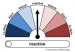
Dial: Example of the El Niño–Southern Oscillation (ENSO) Outlook dial pointing to Inactive when ENSO is neutral and there are no signs of El Niño or La Niña developing
What is the El Niño–Southern Oscillation?
People often want to understand why our weather is either very wet or very dry.
The Bureau gives details about Australia's climate drivers, to help explain the weather. These climate drivers include the El Niño–Southern Oscillation (ENSO).
ENSO is a natural cycle in the global climate system. It describes changes in the tropical Pacific Ocean that affect global weather.
These changes include:
- a shift in sea surface temperatures in the central to eastern tropical Pacific Ocean; and
- their connection with the trade winds and patterns in the atmosphere.
El Niño is the warm phase of ENSO, where it can be drier than usual in eastern Australia.
La Niña is the cool phase, where it can be wetter than usual for northern and eastern Australia.
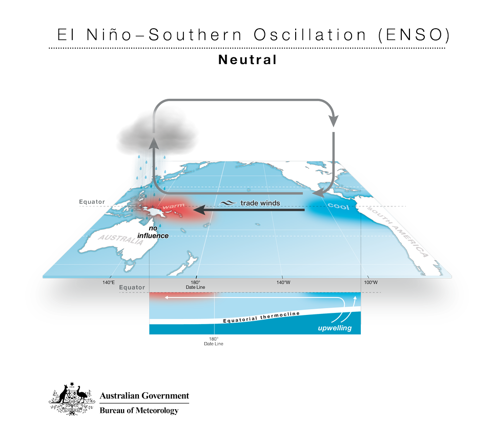
Diagram: The El Niño–Southern Oscillation when conditions are neutral in the tropical Pacific Ocean – neither El Niño nor La Niña
What is the ENSO dial?
We use a dial to show major changes in ENSO conditions as they move between La Niña and El Niño.
We move the point on the ENSO dial to help show:
- the chance of an El Niño or La Niña event forming in the coming season; or
- when Australia is being affected by an event.
For example, this is the dial pointing to El Niño Watch:
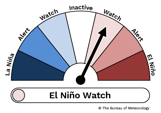
Dial: The ENSO dial pointing to El Niño Watch
What does Watch mean for Australia?
When the dial points to Watch this means:
- there are some signs of an El Niño or La Niña forming in the coming season
- signs may be either from the Pacific Ocean or the overlying atmosphere
- long-range climate model forecasts suggest an event may occur.
When the ENSO Outlook has reached Watch, an event has developed in about half of those years.
When we shift the dial to Watch, this does not guarantee an El Niño or La Niña event will form. There's still about a 50% chance that an event will not develop.
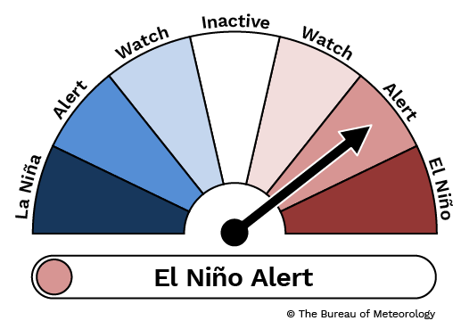
Dial: The ENSO dial pointing to El Niño Alert
What does Alert mean for Australia?
When the dial points to Alert this means:
- there are signs of an El Niño or La Niña forming in the coming season
- signs will be from both the Pacific Ocean and the overlying atmosphere
- long-range climate model forecasts suggest an event may occur.
When the ENSO Outlook has reached Alert, an event has developed around 70% of the time.
When we shift the dial to Alert, this does not guarantee an El Niño or La Niña event will form. There's still about a 30% chance an event will not develop.
What triggers the shift from Watch to Alert?
We will move the point on the dial from Watch to Alert when there are extra signs of an event forming.
The point on the dial can also shift back from Alert to Watch. This may happen if the conditions in the Pacific Ocean change and there is less chance of an event forming.
What does Inactive mean?
When the dial points to Inactive this means:
- conditions are neutral in the tropical Pacific Ocean – neither El Niño
nor La Niña - there are no signs of El Niño or La Niña developing.
ENSO conditions have been neutral in about half of the years since 1900 and the dial points to Inactive when an event is unlikely.
When is an El Niño or La Niña event announced?
We will only announce a La Niña or El Niño event in the tropical Pacific after several climate indicators pass thresholds.
Our climatologists track conditions in the atmosphere and ocean across the Pacific, and refer to expected conditions in the months ahead from several global climate models.
We announce a change when we have observed a trend over several weeks to months in ENSO indicators including:
- sea surface temperature anomalies in parts of the Pacific Ocean (NINO3.4 region)
- sub-surface temperatures in the equatorial Pacific Ocean
- cloudiness around the equator near the International Date Line
- equatorial Pacific trade winds
- Southern Oscillation Index – which measures changes in the overlying atmospheric circulation patterns.
We also view the ENSO long-range forecasts with caution during late summer and autumn. ENSO forecasts can be less accurate when looking too far ahead during the first half of the year, compared to other times of the year.
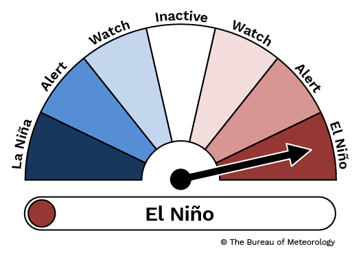
Dial: The ENSO dial pointing to El Niño
How does the Bureau decide on the dial level?
We have criteria that guide our warning system for El Niño and La Niña.
To help decide on the dial level, we review climate indicators and the long-range forecast against our criteria.
The criteria are available on our website.
How often is there an El Niño or La Niña event?
Around half of the years since 1900 have been either El Niño or La Niña.
El Niño occurs on average every 3 to 5 years.
La Niña occurs on average every 3 to 7 years.
How often is the ENSO Outlook updated?
The Bureau updates the ENSO Outlook every 2 weeks.
We share this information in the regular Climate Driver update.
Why do some international agencies have a different level of ENSO warning?
There is no single definitive index or measure of the El Niño–Southern Oscillation.
The US, Japan and Australia each have slightly different metrics for monitoring ENSO. This can lead to national agencies announcing a La Niña or El Niño event at different times.
In general, meteorological agencies have tailored their services around the impact of La Niña and El Niño for their country. The Bureau considers its service best suited for Australia.
What's the significance of climate drivers like El Niño or La Niña?
Changes to the dial do not change our long-range forecast.
We produce long-range forecasts using a version of its weather model.
This model incorporates observations of the global atmosphere and oceans. These observations include the current state of climate drivers, like El Niño and La Niña.
El Niño and La Niña are not the only climate drivers affecting Australia.
Climate drivers give us more information on the major influences that have had a big impact on Australia's climate in the past.
This information also helps us predict the likely impacts for the Australian region.
This can help communities prepare for likely climate conditions.
The long-range forecast for rainfall and temperature is more useful than any differences in the timing of the announcement of a La Niña or El Niño event.
More information
- Long-range forecast
- Climate Driver Update
- More information about El Niño and La Niña
- Subscribe to receive climate information by email.

Comment. Tell us what you think of this article.
Share. Tell others.