
La Nina reaches its end
05 July 2011
The Bureau of Meteorology's climate update issued on 25 May, announced the final 'curtain call' for the climate phenomenon known as La Niña.
Climate information explained - how the Bureau uses climate data in our work (text transcript)
Dr Andrew Watkins, Manager of the Bureau's Climate Prediction Services, said the La Niña had played a spectacular and at times devastating role in shaping Australia's climate since mid-last year. However, rapid changes in Pacific climate patterns had finally brought the event to a close.
'This most recent La Niña [2010-11] will go down in the record books as one of the strongest in living memory. It's been nearly 40 years [1975-76] since Australians have witnessed a La Niña event of this intensity,' said Dr Watkins.
'La Niña is characterised by the central Pacific Ocean being considerably cooler than average, combined with the Southern Oscillation Index running at very high levels.
These conditions have now returned to a neutral climate phase – neither La Niña nor El Niño. The outlook for winter is for conditions to stay neutral. A clearer picture of the likely conditions for the coming spring and summer will emerge over the coming months'.
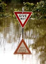
La Niña typically brings wetter conditions for Australia with cooler days, warmer nights and increased tropical cyclone activity. The 2010-11 La Niña brought all this and more, breaking rainfall records and delivering devastating floods and cyclones.
- Australia experienced its wettest September, December and March, with October and February the second wettest, since at least 1900.
- Northern Australia recorded its wettest 'dry season' (May-October) and second wettest 'wet season' (November-April) on record.
- Australia's daytime temperatures for the 12 months to April 2011 were the fourth coolest on record, 0.7°C below average, with night-time temperatures for the same period almost 0.25°C above average.
- Three tropical cyclones (Tasha, Yasi, Anthony) crossed the Queensland coast, while Carlos broke rainfall records in the Northern Territory, including Darwin's wettest day on record - 367mm.
- In contrast, southwest Western Australia remained extremely dry, with 2010 its driest on record.
Bureau climatologists continue to monitor conditions and climate models closely, with fortnightly updates published on the Bureau's El Niño Southern Oscillation Wrap-Up webpage.
Comment. Tell us what you think of this article.
Share. Tell others.