
Driest July on record for southwest Western Australia
23 August 2012
The southwest of Western Australia has had its driest July since records began over a hundred years ago. Record low rainfalls were recorded at many sites across the region including Perth, Northam, Narrogin, and Wagin. Only 34.6 mm of rain fell over just eight rain days in Perth, well below the long-term average of 169.6 mm and the previous record low of 61.5 mm in 1876.
Why so little rain?
An absence of wintertime cold fronts and a southward shift in the westerly wind flow meant less rain for the area. Strong high pressure systems brought dry, sunny and often calm conditions, rather than the usual cloudy, wet, and windy weather.
The lack of cloud cover, light overnight winds and long nights also produced record-low minimum temperatures at a number of sites. Perth Metro recorded nineteen cold nights (with minimum temperatures below five degrees), beating the previous record of sixteen cold nights, recorded in 1998, 2001, and 2010. The average for July is slightly less than eight cold nights, based on records from the current Perth Metro site since 1994.
Winter beyond July
The beginning of August finally saw some significant rainfall as several frontal systems crossed the southwest of the state. In the first three days of the month Perth Metro recorded almost 30 mm, not far below the July total.
The current seasonal outlook suggests the chances are roughly equal of a drier or wetter-than-normal August to October period.
The trend in southwestern Australia
This year marks the third driest start to winter for the Perth Metro site with 175.4 mm observed on twenty-six rain days in June and July. It is the driest start to winter since 2006, which was Perth's driest winter on record.
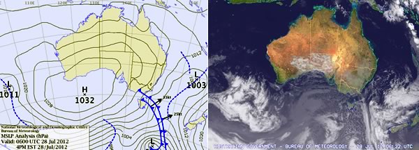
An example of the dominant high pressure pattern over southwest Western Australia in July 2012 with accompanying satellite image
Southwestern Australia has had a substantial decline in annual rainfall, affecting the April to July period. The first sign that rainfall was declining came in the late 1960s when a significant drop in early winter rainfall was observed. July rainfall since 2000 has averaged nearly 20 per cent below the 1900 to 1968 average.
See Indian Ocean Climate Initiative – Western Australia
The decline in rainfall in southwestern Australia has been associated with changes in the large scale atmospheric circulation in the region. Some studies have linked these changes with human activities. Greenhouse gases have increased, stratospheric ozone in the Southern Hemisphere has reduced, and sulphate aerosols from industrial pollution are possibly increasing.
The link between the drying climate and the enhanced greenhouse effect means that a reversal of the drying trend is unlikely. This century, we can expect future drying of the southwest climate, including Perth.
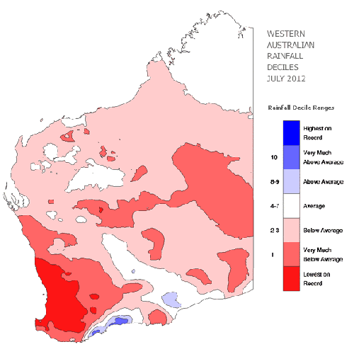
Rainfall deciles for July show below-average rainfall for much of Western Australia, with lowest-on-record rainfall for the southwest (go to archive image).
Comment. Tell us what you think of this article.
Share. Tell others.