
Radar-derived rainfall accumulations
13 September 2012
Distribution and intensity of rainfall is notoriously difficult to measure. Rain gauges accurately measure rainfall at the points they are situated, but don't capture variation over an area. In contrast, radars have a good geographic coverage, but measure precipitation in the atmosphere rather than the amount of rain reaching the ground.
The Bureau's solution
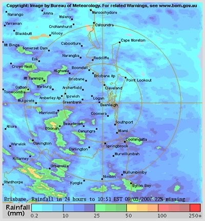
Example of a frame from a loop of rainfall accumulation over the last 24 hours.
Scientists working on the Bureau's Strategic Radar Enhancement Project, have blended measurements from rain gauges (accurate point data) and radar (excellent spatial coverage). Radar data is calibrated with rain gauge data and is used to fill in the "gaps" between rain gauges. The exciting new product produced by this method is known as a rainfall accumulation image.
Rainfall accumulation images
Rainfall accumulation images show estimated total rainfall over a particular duration (6 or 10 minutes, 1 hour, 24 hours, and since 9am).
They:
- improve accuracy over single radar images in a timely manner
- are capable of reproducing the spatio-temporal structure of rain.
Current and future usage
Although the science behind rainfall accumulation images is still relatively new, they are already being used by meteorologists in weather and severe weather forecasting, and by hydrologists for flood modeling and heavy rainfall conducive to flash flooding. The rainfall accumulations can be used to calculate how "rare" a rainfall event is by expressing it in terms of "one in X years event". Emergency services use the images to decide if flood mitigation action may be required.
The Strategic Radar Enhancement Project has recently made an exciting leap by using these images for "nowcasting"—the prediction of rainfall in the coming 30–240 minutes. The rainfall nowcasts are being combined with the rainfall accumulations to calculate the probability of reaching certain rainfall accumulations in the future which is used to provide alerts for possible severe weather.
Rainfall accumulation images are currently produced for 12 of the Bureau's 65 radars. This will continue to be extended. The eventual aim is to combine the radar data with numerical models to improve the accuracy of forecasts for the next 12 hours.
Comment. Tell us what you think of this article.
Share. Tell others.