
Great underground basin: out of sight, not out of mind
24 October 2012
Australia's fabled inland sea is actually underground in an aquifer named the Great Artesian Basin. The basin stretches across one-fifth of Australia, from Cape York in far-north Queensland to Dubbo in central New South Wales.
It stores enough water to fill Lake Gordon (Australia's largest surface-water storage) almost 6000 times. Some of the water in the basin has been there for more than two million years.
Groundwater is the source of about 25 per cent of Australia's water supply, and it needs to be managed carefully to avoid being depleted. The Bureau receives data on groundwater levels and pressures for thousands of bores from dozens of organisations.
This information is blending with hydrogeological information on the nation's aquifers. The Bureau is also working with researchers and water agencies to develop a three-dimensional picture of groundwater resources.
Among other benefits, this will help show how climate, groundwater extraction, and land and river management regimes affect groundwater availability and quality.
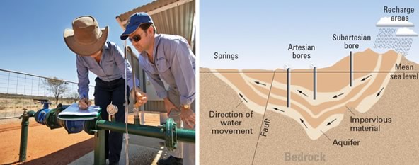
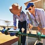
Nerida Beard of NT Power and Water Corporation and Nigel Mules of the Bureau of Meteorology's Darwin office inspect groundwater monitoring equipment at Yuelamu, 300 kilometres northwest of Alice Springs. Photograph by Lynton Crabb. A generalised cross-section of the Great Artesian Basin is shown at right.
Comment. Tell us what you think of this article.
Share. Tell others.