A look inside the structure of a tropical cyclone
19 November 2012
Over warm tropical oceans, a cluster of thunderstorms can start rotating around a common centre, due to the earth's rotation. If the conditions are just right, this process can sustain itself and create a tropical cyclone.
At this stage, the tropical cyclone is like a giant, atmospheric heat engine. The moisture from the warm oceans is its fuel, generating huge amounts of energy.
Clouds lift the heat into the atmosphere
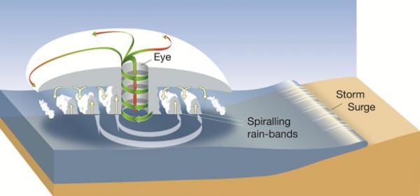
The rotating thunderstorms form spiral rainbands. Their clouds, circling around the eye of the cyclone where the strongest winds are found, transport heat 15 km or higher into the atmosphere. There, drier cooler air becomes the exhaust gas of the heat engine.
Some of this cool air sinks into the low-pressure region at the centre of the cyclone—the relatively clear and calm eye. The rest of the cool air spirals outward, away from the cyclone centre, sinking in the regions between the rainbands.

Diagram of a tropical cyclone system
Rising seas lead to storm surges
As well as damaging winds, a tropical cyclone can cause the sea to rise well above normal tide levels when it comes ashore. These storm surges are caused by strong, onshore waves or reduced atmospheric pressure—or both. Potentially, they are the most dangerous hazard associated with a tropical cyclone.
As long as the environmental conditions support this atmospheric heat engine, the tropical cyclone can maintain its structure and even intensify.
For more information about tropical cyclones visit the Tropical Cyclone Knowledge Centre. For the latest tropical cyclone warnings and advice visit www.bom.gov.au/cyclone


Comment. Tell us what you think of this article.
Share. Tell others.