
The Australian Groundwater Explorer: A new way of exploring our precious underground resource
24 October 2014
As part of National Water Week, the Bureau released an online mapping tool that enables you to check local groundwater resources at the touch of a button.
Although it often sits just metres beneath our feet, groundwater can be an overlooked resource: the hidden treasure in Australia’s water landscape. We all know about our rivers and dams, our springs and wetlands—the vital ecosystems so close to the surface of our national conscience—but fewer people realise just how critical subterranean water is to life above ground.
The intense use of many of Australia’s aquifers has brought into sharp focus the need for more detailed knowledge of our groundwater resources, and more informed and concerted efforts to ensure their sustainability. Some bores and springs have now ceased to flow. In recent years, Federal and State governments have stepped up their efforts to promote more sustainable groundwater management, including tougher licensing of bores and greater monitoring of their levels, quality and recharge patterns.
This monitoring has enabled State, Territory and regional water authorities to collect unprecedented data on aquifers and management of nearly 800 000 bores, which is now being made available to the public through an interactive portal on the Bureau of Meteorology’s website. For the first time, this information has been compiled and made available as a single, nationally consistent dataset.
Launched on 21 October, the Australian Groundwater Explorer is a customisable mapping tool that allows users to ‘zoom in’ to any part of the country to explore particular aquifers and the bores accessing their water. Sophisticated software enables users to access detailed ‘logs’ on the construction, hydrogeology and rock formations intersected by individual bores, as well as key data on specific aquifers, surface geology, sedimentary basins, and other factors that can influence groundwater replenishment and resilience.
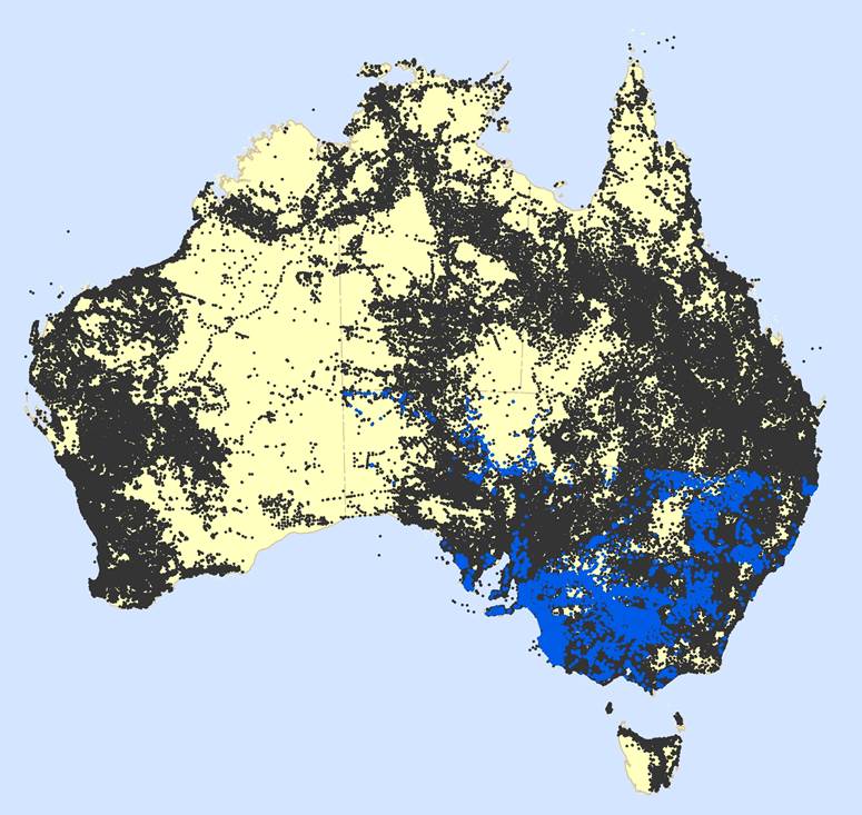
Data from over 800 000 bores are available in the Australian Groundwater Explorer
Users with the latest Adobe software can also access illuminating 3D maps of individual aquifers, which offer a uniquely all-encompassing picture of their basins, geological formations, bore locations, and aquifer interactions with the surface to provide an understanding of recharge from rainfall, floods and river beds. All information in the Explorer is updated annually with the latest data from State and Territory water agencies. The Explorer is highly extensible, allowing for an almost limitless addition of future groundwater data as it becomes available.
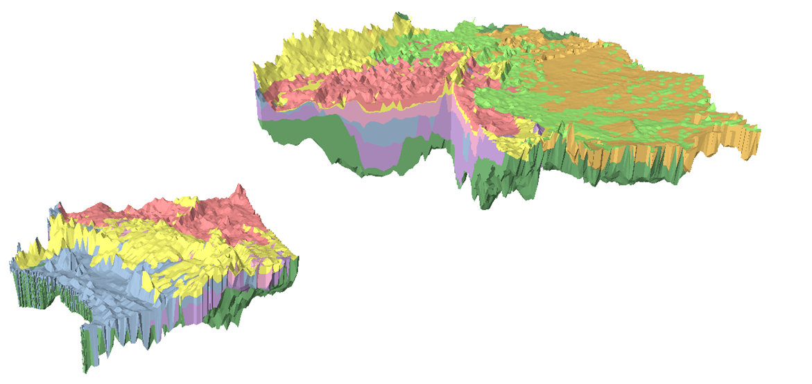
3D model of the Murray Basin
Uses across the community
As well as being a useful planning tool for water agencies and policymakers, the Explorer offers a host of practical uses for a range of Australians: from landowners planning to drill new bores on their properties, to farmers monitoring the water in their regional aquifers; responsible industries that want to prioritise sustainable water use, or community groups concerned about the potential impacts of mining operations.
The Explorer is one of a suite of products delivering comprehensive water data compiled over the past seven years by the Bureau’s Improving Water Information Programme. The Programme receives data from more than 200 water managers and providers, from Federal, State and Territory water authorities and corporations, to water utilities, irrigation companies, environmental managers, and other agencies involved in the collection and management of water information and resources.
The Groundwater Explorer is one of a raft of online groundwater resources and databases maintained by the Bureau, including an interactive Atlas of Groundwater Dependent Ecosystems, a National Aquifer Framework which standardises the description of geological formations between States and Territories, and an underpinning National Groundwater Information System for technical experts which combines State and Territory groundwater information.
Together, these resources offer a comprehensive national picture of Australia’s least understood water resource—a resource that makes up some 17% of the country’s accessible water resources, and accounts for up to 30% of water consumption in regions such as Perth where surface water is scarce or droughts more commonplace.
As climate variability and population growth continue to place greater pressure on our water resources, the importance of our ‘hidden’ water treasure will continue to grow. The ongoing development of nationally consistent standards and systems for recording groundwater information, and making it publicly available in clear and accessible formats, will continue to support the vital work of our water managers and policymakers. It will also provide a robust platform for concerned citizens to ensure the continuing sustainability of this most precious resource.
Comment. Tell us what you think of this article.
Share. Tell others.