
Rising knowledge: How sea-level monitoring is uniting the Pacific Islands
09 April 2015
The Bureau of Meteorology has recently released two short videos that give an insight into how sea-level monitoring is carried out in the world’s largest ocean—and why it is so crucial.
Visitors walking along the seafront in most Pacific Island capitals will invariably stop to admire the fishermen perched patiently at the end of the town wharf, or the procession of young boys plunging fearlessly into the turquoise waters. But they’ll rarely offer a second glance at the small, nondescript, white buildings that cling to the seaward end of these busy wharves.
|
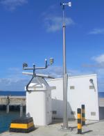
There’s no sign to tell visitors that these modest buildings—often little more than small fibreglass huts—have been providing vital environmental intelligence to the entire Pacific region for more than 20 years. These buildings are sea-level monitoring stations—a modern version of the humble tidal gauge. They house a variety of state-of-the-art instruments that continuously monitor the ocean and weather conditions, relaying a steady stream of data to the host country and the Bureau of Meteorology in Australia. 13 stations located across 12 countries form the backbone of one of the world’s most important ocean-monitoring networks. They provide an indispensable record for meteorological agencies, emergency services, shipping operators, and a huge range of industries across the South Pacific. |
Sea-level monitoring station in Funafuti, Tuvalu |

Where the ocean rules
In the remote archipelagos of the southwest Pacific, daily existence and livelihoods are closely intertwined with the ebb and flow of the tides. For these small island nations, information on sea level and the dynamics of the tides serves a vital role in planning for sustainable development, protecting lives and property, and building local industries.
Since 1991, the Bureau of Meteorology has been working in partnership with Pacific Island governments to monitor sea levels and tides, beginning with the installation of the sea-level monitoring stations across the region. At present the Pacific Sea Level Monitoring Project forms a key component of the Climate and Oceans Support Program in the Pacific (COSPPac), made possible with funding from Australia’s Department of Foreign Affairs and Trade.
The monitoring stations employ a sophisticated series of acoustic, water pressure and radar sensors—the most sensitive and accurate of their kind. These record changes in sea level to within one millimetre, together with the wind speed and direction, air and water temperatures, and the atmospheric pressure. Data are captured each minute and sent via satellite to Adelaide, where they are analysed by hydrographers and tidal experts before being relayed to meteorological services across the Pacific.
Datasets produced by the monitoring stations include everything from the daily tide times and forecasts relied upon by local fishermen, to the severe weather warnings and long-term tide calendars that inform sailors and shipping companies, diving and tour operators, natural disaster managers, surveyors, town planners, and policymakers developing long-term climate adaptation strategies.
Today, real-time data and observations from individual monitoring stations are available directly to the public through a special portal on the Bureau’s website (choose the country/station through the Settings tab).
A precise science
Each sea-level monitoring station is also partnered with a land-based geodetic monitoring station, which uses a satellite navigation system such as GPS to continually track the movement of the land from subsidence or earthquake activity. Together with regular surveying work, these land-monitoring stations enable land movements to be recorded for later analysis alongside sea-level changes—making the measuring of sea-level rise a much more precise science.
Such measurements are crucial in settings like the Pacific, where sea-level trends have critical implications not only for short-term planning for inundation and tidal events, but for longer-term infrastructure development and climate change adaptation. In addition, data from the geodetic stations enable the creation of a unique ‘geodetic baseline’, which has contributed significantly to negotiations between neighbouring countries over their maritime boundaries.
Today, several maritime experts cite the Pacific Islands as a global leader in the field of maritime boundary resolution—a notoriously complex business, often characterised by disputes over islands, seamounts and natural resources.

Diagram of a typical sea-level monitoring station which measures sea-level using three different sensors, as well as wind speed and direction, air and water temperatures, and atmospheric pressure.
Reaching across the region
The steady march of technology, together with the uniting of Pacific Island nations over the looming challenges posed by climate variability and change, have led to a rapid acceleration in the use of environmental information from the Pacific Sea Level Monitoring Project. With a dataset extending back nearly 25 years, the project today provides highly important, continuous records of sea-level trends. These hold enormous value to those working to record and assess the impacts of climate change.
At a community level, one of the project’s most important achievements is the valuable information provided to fishermen and mariners across the Pacific. In most countries, the high and low tide forecasts are read on national radio at least twice a day. Fishermen and women use this information to time their offshore fishing trips, as well as expeditions to collect shellfish, sea plants and other edible species from reefs and tidal flats.
An overview of the sea-level work being done in the region
Pacific governments routinely use the Bureau’s monthly and annual tide calendars to predict the highest astronomical tides, or ‘king tides’, which are announced on the radio and through community pamphlets. In 2013 and 2014, the Kiribati Meteorology Service made visits to vulnerable, low-lying communities on Tarawa a few days ahead of predicted inundations—giving people plenty of time to secure their homes and evacuate. Similarly, in Tuvalu, where low-lying areas frequently succumb to inundation, the National Disaster Management Office regularly draws on the Bureau’s tide calendars to provide warnings before king tides.
The project’s tide and geodetic data have also helped several countries to update their navigational charts for shipping. Last year in Vanuatu, the Secretariat of the Pacific Community (SPC) and the Vanuatu Lands Survey Department used the data to update and digitise charts for the Port of Luganville in Espiritu Santo. Without such charts, international cruise ships and container vessels would be unable to stop on the island—resulting in significant economic losses.
The importance of sea-level monitoring in Tuvalu
The project’s geodetic data is of particular importance to geographic information experts at SPC who assist countries in ‘delimiting’ their maritime boundaries. In March 2014, the Cook Islands became the first Pacific nation to complete negotiations with all of its neighbours to finalise its maritime boundaries. Finalising these boundaries gives countries definitive access to any resources within their ‘exclusive economic zones’, including fish and deep sea minerals. To date, 33 of the 48 boundaries in the Pacific have been delimited and agreed.
There have been several other recent breakthroughs using the project’s data. In 2013, information from Fiji’s Suva monitoring station was used in the creation of a training simulation of Suva Harbour, to help train ship pilots from around the Pacific region. Previously, Pacific pilots had been trained on simulations of ports in Singapore, Australia and Malaysia, but this was the first time a simulation had been designed using a Pacific harbour.
The project’s sea-level monitoring stations also have a vital role in providing real-time data for the tsunami warning systems operated by the Joint Australian Tsunami Warning Centre and the Pacific Tsunami Warning Center in Hawaii. This potentially lifesaving information has been channelled into several national projects, with SPC hydrodynamic modellers producing a tsunami model for a major earthquake in the Tonga Trench, based on data from the Nuku’alofa station. The model has helped the Government of Tonga to develop a number of emergency measures—including plans to construct elevated evacuation sites throughout the city.
More information
The Pacific Sea Level Monitoring Project is run with funding from the Australian Department of Foreign Affairs and Trade and with technical support from COSPPac, Geoscience Australia, Pacific Island governments, and the Secretariat of the Pacific Community.
More information about the project can be found at the COSPPac website.
Comment. Tell us what you think of this article.
Share. Tell others.