We’re calling it, the 2015 El Niño is here
13 May 2015
We’re calling it.
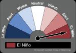
The Bureau’s ENSO Tracker status has moved from ALERT to EL NIÑO, signalling the official declaration by the Bureau of Meteorology of El Niño 2015.
El Niño is often associated with drought in Australia. It may be cold comfort for those toughing out the current dry in parts of eastern Australia, but while El Niño certainly raises the risk of drought, it doesn’t guarantee it. Of the 26 El Niño events since 1900, 17 have resulted in widespread Australian drought.
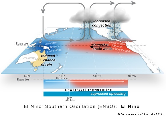
El Niño has been around for millennia, and is essentially a shift in the climate patterns of the Pacific region driven by changes in the ocean. In the simplest terms, El Niño occurs when some of the warmest ocean waters in the world – northeast of Papua New Guinea, where the ocean can exceed 30 °C – shift east towards South America.
As the warmth shifts east, so does the cloud and rain, and Australia becomes dominated by big, dry, cloudless and rainless high-pressure systems.
So what are the criteria to declare El Niño, and why did it shift this time and not last year?
Declaring an El Niño
The criteria for calling El Niño are on our ENSO Tracker page, and in short we need to see at least three of the four following things:
-
tropical Pacific sea surface temperatures at least 0.8 °C above normal (currently they are 1.1C above the mean, and April averaged 0.82 °C above);
-
trade winds weaker than average (generally weak or even reversed since January 2015);
-
the Southern Oscillation Index (SOI) below –7 (it has been negative pretty much since July 2014);
-
climate models are confident it will continue ( all models we survey say ocean temperatures will remain at El Niño levels at least into late 2015.
Why do we care about these four ocean and atmospheric phenomena in particular?
The modern definition of an El Niño centres on when the ocean warming drives changes in the atmosphere above it. Some of those changes in the atmosphere (such as a weakening of the trade winds) actually help the ocean warm even more. This in turn drives more changes in the atmosphere.

And around we go, in what’s called a “positive feedback” loop. Once a positive feedback loop is established between the ocean and the atmosphere, we call them “coupled”. And hence the El Niño is likely to be with us until the natural annual cycle of sea surface temperature ends the event early the following year.

The ocean and the atmosphere getting couply
Warmer and drier outlook
We talked about an increase of the odds for El Niño last year, but as published in the Conversation last week, an El Niño never fully developed, and a declaration was never made.
Last year, ocean temperatures along the equator warmed virtually everywhere, meaning little difference emerged between the east and west – and it’s this difference which drives a lot of the changes in the atmosphere.
The difference this time is that the western tropical Pacific Ocean is staying cooler, and the warmest areas are further east, driving bigger changes in the atmosphere. We also started 2015 with warm water already in the tropical Pacific, whereas last year it started from a cool base.
Apart from increasing the chance of drier conditions for many areas, El Niño can also bring higher daytime temperatures to the south, poorer snow seasons, lower streamflows, more heatwaves, longer frost season (cloudless nights in spring), later onset of the northern rains and higher fire danger.

El Niño often brings drier and hotter conditions in winter and spring

The shift in atmospheric patterns also means fewer tropical cyclones – good for the coast but not so good inland where they can bring summer rain.
Right now, our outlook is actually for wetter than normal conditions in many areas – driven by warm water in the Indian Ocean. We explain why in our May Climate and Water video.
However winter and spring are the key times for Australia to experience El Niño impacts. Some areas are already in drought, particularly in Queensland and northern New South Wales, due to the failed northern wet season of 2012–13 and little recovery since. Western Victoria is also suffering long term rainfall deficiencies.
Why El Niño?
The name comes from Peru, where every few years around Christmas (the time of the birth of Jesus “the Boy Child”, or “El Niño” in Spanish), the anchovy fishery would fail as warmer water replaced the normally cool, anchovy-rich water along the South American coast.
So that’s it in a nutshell – we have El Niño on our hands.
To keep yourself up to date with the latest Bureau information about El Niño, see our fortnightly ENSO Wrap Ups for the latest news, sign up to our email list to get the latest climate outlooks, and watch our climate and water videos.
This article was originally published on The Conversation.


Comment. Tell us what you think of this article.
Share. Tell others.