

Far from bore-ing: What is groundwater?
10 May 2016
Updated 8 March 2022
Over time, water from rain and rivers migrates through the ground and is stored in porous soils and rocks forming aquifers. It's called groundwater.
Across Australia, vast quantities of groundwater fill the spaces between grains of soil or rock, and flow slowly. An aquifer (area where groundwater is stored) is more like a sponge than an underground river. Aquifers often connect with rivers, streams, lakes and wetlands, and groundwater can also sustain trees and vegetation.
Australia is a very old continent. Much of its groundwater is tens of thousands, even hundreds of thousands of years old. For example, the Great Artesian Basin in central Australia is the largest aquifer of its kind in the world, covering 22% of Australia. It contains water that last fell as rain more than one million years ago.
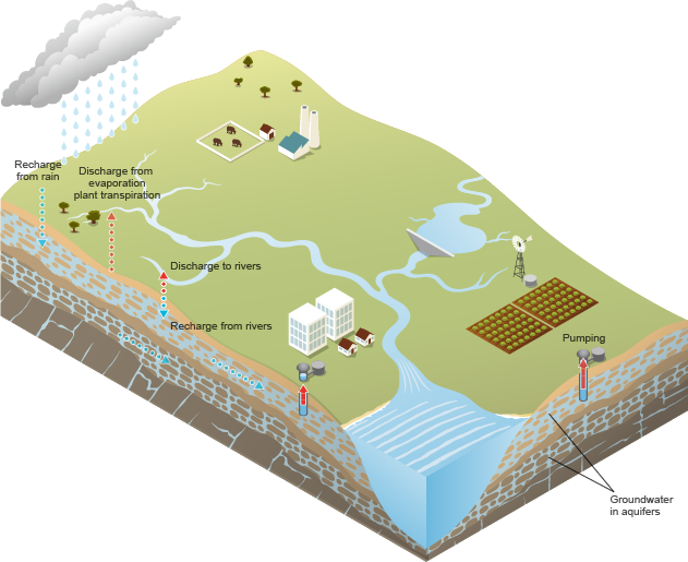
Illustration: The groundwater cycle
Why is groundwater important?
Groundwater makes up 98% of the fresh water on the planet. It currently makes up around a third of Australia’s water consumption, although this varies from location to location. In the Northern Territory, 90% of water is sourced from aquifers. Across the nation, the highest groundwater use is in the Murray–Darling Basin.
In many regions of Australia, particularly in the outback, groundwater is the only available source of water. Many townships, farms and mines are totally reliant it. Farmers sink bores that allow groundwater to flow to the surface from artesian basins. They use modern pumps or windmills to extract water from non-artesian aquifers. In irrigation areas, vast quantities of bore water supply thousands of hectares of crops and pastures. Even large cities are dependent on groundwater. For example, about 70% of Perth's water comes from groundwater (National Water Account 2021).
In many places, groundwater discharges naturally to the surface, bubbling into natural springs or contributing to wetlands. Groundwater often plays a crucial role in sustaining rivers and streams, particularly during droughts. Many ecosystems, including some of our most iconic, depend on groundwater. These include the River Murray and Great Artesian Basin mound springs.
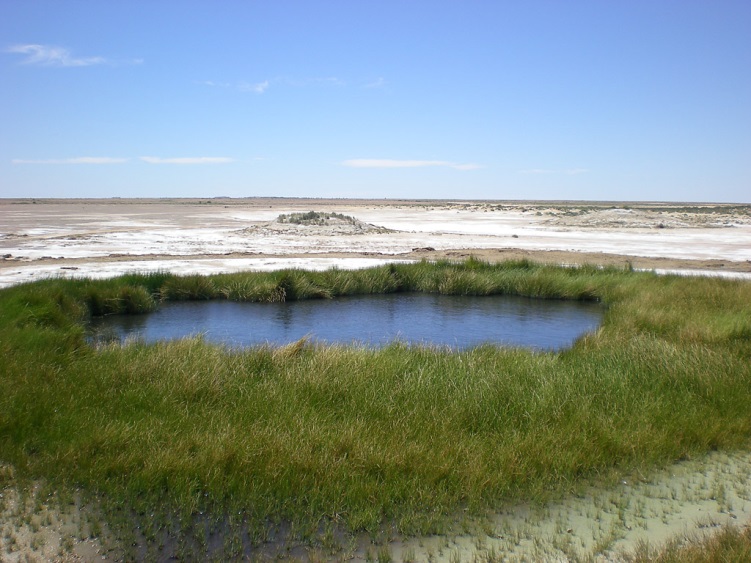
Image: A mound spring on the Oodnadatta Track, South Australia, which is dependent on groundwater. Credit: Luke Doherty
Insight into groundwater
The Bureau provides a suite of groundwater information products. This includes web mapping that lets you zoom in and explore nationally consistent groundwater information and data for your area.
One of these portals is Australian Groundwater Insight, which is mobile-friendly. It's designed for non-experts. Anyone can explore hydrogeological information alongside information about licences, bore density, management areas and groundwater trends.
For example, a farmer could look at groundwater levels over the past 5, 10 and 20 years to see if the trends nearby are rising, stable or declining. They can also view groundwater level status, to see if the bores in their area have above-average or below-average levels. This information can be combined with their entitlements to influence how they might use groundwater on their farm.
If the farmer decides to drill a bore, they could then use the Australian Groundwater Explorer for specific information from nearby bores. They could look at actual water levels and salinity, the drilled depth, and bore logs near their property. This would help inform them about the materials they might be drilling through (such as sand or clay) and which aquifer they should target.
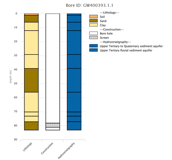
Diagram from the Groundwater Explorer showing information on:
- lithology – depth and type of sediments drilled through
- construction – bore and screen depth
- hydrostratigraphy – depth and type of aquifers drilled through.
More information: www.bom.gov.au/water/groundwater
More information
Visit National Centre for Groundwater Research and Training for resources, including webinars and Groundwater in Australia.

Comment. Tell us what you think of this article.
Share. Tell others.