
Plane talking: tracking and forecasting volcanic ash
03 August 2016
It’s one of the top international holiday destinations for Australians, but Indonesia is also home to some of the world’s most active volcanoes—with volcanic ash regularly causing significant flight disruptions. So why is volcanic ash a serious safety hazard for the aviation industry and how does the Bureau track and forecast its movement?
What is volcanic ash?
Volcanic ash in the air is a mixture of fine pulverised rock, minerals and glass, and is accompanied by gases which convert into droplets of sulphuric acid and other substances. It’s extremely hazardous to aircraft, with the potential to melt in the engine, and fuse into a glass-like coating on components, causing loss of thrust (the force that propels the plane through the air) and possible engine failure. It can also cause abrasion of engine parts, and the body of the aircraft, and clog fuel and cooling systems.

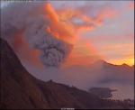
Photo: Mt Rinjani eruption, Lombok, 5 November 2015. Credit: Centre for Vulcanological and Geohazards Mitigation.
In June 1982 a British Airways 747 suffered severe damage and had all four engines fail after encountering ash from Mt Galunggung in Indonesia. It descended to 12 000 feet (normal cruising height is around 38 000 feet) before restarting some engines and making an emergency landing in Jakarta.. Three weeks later the same thing happened to a Singapore Airlines 747, which lost two engines and also made an emergency landing.
These incidents drove a major international effort to start tracking and warning aircraft of volcanic ash clouds.
Volcanic activity
The highest concentration of active volcanoes in the world lies along the rim of the Pacific Ocean—the so-called ‘Pacific Ring of Fire’. This 40 000 km horseshoe-shaped area stretches along the western edge of the Americas, across to the Kamchatka Peninsula (Russia), down through Japan and the Philippines and across Indonesia, Papua New Guinea and New Zealand to the islands of the South Pacific. It is associated with a nearly continuous series of oceanic trenches, volcanic arcs, and volcanic belts and/or plate movements. Other active regions are the Great Rift Valley in Central and East Africa, countries around the Mediterranean, and Iceland (home of Eyjafjallajökull, which erupted in 2010, famously grounding flights in 20 countries across Europe and affecting around 10 million travellers).

Pacific Ring of Fire. Oceanic trenches are shown in blue. Credit: U.S. Geological Survey.
Volcanic eruptions range in nature from a quiet, steady outpouring of lava to highly explosive eruptions which blast several cubic kilometres of ash and corrosive gases high into the atmosphere over a wide area for several days. This explosive activity is of greatest concern to aviation, mainly because of the great volume of ash and the height that the volcanic material can reach. An ash cloud from a large eruption can remain in the atmosphere in dangerous concentrations for many days. Over this time, it can travel many thousands of kilometres with the prevailing winds.
Monitoring volcanic ash
Globally there are nine volcanic ash advisory centres (VAACs) that detect, track and forecast the movement of volcanic ash clouds and provide advice to meteorological offices in their area of responsibility. The VAACs are located in the USA, Argentina, UK, Australia, Japan, France, Canada and New Zealand.
The Bureau’s VAAC (known as VAAC Darwin) is responsible for an area that includes the volcanically active regions of Indonesia, Papua New Guinea and the southern Philippines—and monitors 152 active volcanoes. It provides advice to the aviation industry about the location and movement of potentially hazardous volcanic ash, using ground-based and satellite observations, pilot reports, and sophisticated forecasting models. The VAAC operates 24 hours a day.
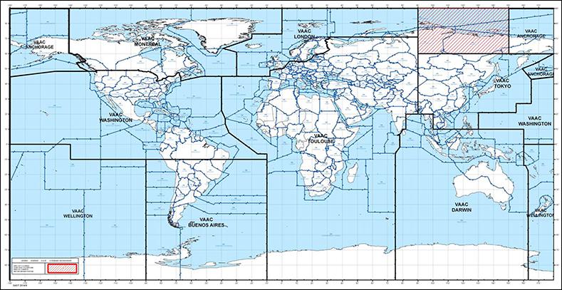
Volcanic Ash Advisory Centre (VAAC) locations and their areas of responsibility.
Forecasts and warnings
The Bureau issues specialised, technical reports for the aviation industry, including Volcanic Ash Advisories (VAAs), and Volcanic Ash SIGMETs. Pilots flying over areas known for volcanic activity are required to review advisories and forecasts and monitor updates en route. However, airlines make their own decisions on when to fly based on their risk-management policies.
VAAs are issued every six hours following a volcanic eruption, and more frequently if the situation changes significantly. They include information on the location of the volcanic ash, the ash's height in the atmosphere, and the forecast movement of the ash over the next 18 hours. SIGMETs, issued when there are meteorological conditions hazardous to aviation present (such as thunderstorms, hail, cyclones etc.), are also issued specifically for volcanic ash. Based on the VAAs, these give pilots details about the location, extent, expected movement and change in intensity of the ash cloud, for a specific area (or flight information region), for the next six hours.
While long-term forecasting of volcanic eruptions is not possible, vulcanologists are able to give short-term forecasts based on factors such as seismic activity and ground deformation (the way the ground changes shape around an eruption). Although primarily used for providing warnings to local communities, this information can also be used by the VAAC in providing advice to the aviation industry on imminent eruptions and their expected nature (e.g. whether an eruption is likely to reach cruising levels).
The movement, spread and dispersion of volcanic ash clouds depends on:
- the altitude reached by the ash cloud (of primary importance);
- the nature and strength of the eruption;
- the meteorological condition of the atmosphere, e.g. atmospheric stability, wind behaviour and precipitation (ash particles can be ‘rained out’); and
- the ash concentration and the size distribution of particles—finer particles travel further and remain in the atmosphere for longer, while heavier particles fall out of the flying zone sooner.

Photo: Jetstar presented the Bureau’s VAAC with this ‘thank-you’ for its support during the Mount Raung and Mt Rinjani ash cloud events in 2015.
More information
How Qantas and other airlines decide whether to fly near volcanoes (The Conversation)

Comment. Tell us what you think of this article.
Share. Tell others.