
Research: how mountain waves can escalate bushfires
04 April 2017
One of the most challenging situations in bushfire management is when a fire unexpectedly transforms from benign to severe. Understanding why past fires developed in unexpected ways could help to avoid this situation in the future. The Bureau has worked with the Bushfire and Natural Hazards Cooperative Research Centre (BNHCRC) to better understand how ‘mountain waves’ have contributed to severe fire.
What are mountain waves?
Mountain waves are oscillations in airflow that can happen when the wind blows across a mountain or hill. You can think of them as the air equivalent of water flowing over a rock in a stream—but they’re much more complex because their existence, size and intensity are sensitive to the how the temperature and wind vary with height. They often lead to strong winds on the lee slope (the side that’s sheltered from the wind) of the mountain or hill. This is known as ‘downslope’ wind.
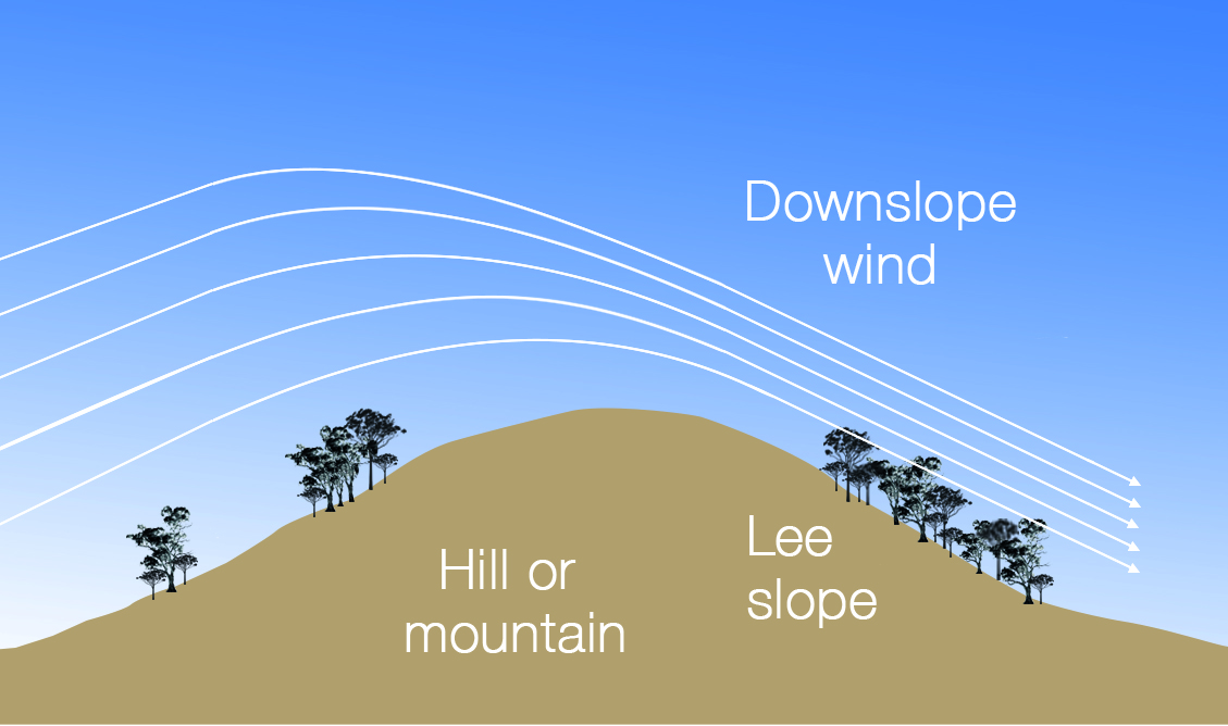
Image: Near-surface air flow of a mountain wave.
Mountain waves and bushfire
If a mountain wave occurs and a fire is present, the fire may become unexpectedly severe as the strong downslope wind fans the flames.
Working with the BNHCRC, we studied three bushfires where fire behaviour ramped up unexpectedly, leading to extremely hazardous conditions, environmental damage and the loss of property. By reviewing meteorological conditions, topography and fire behaviour, we found that mountain waves were a strong contributing factor to the change in expected behaviour of all these fires:
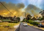
- the Blue Mountains (New South Wales) fires of October 2013, particularly the State Mine Fire, which grew from 1036 ha to 12 436 ha in around 10 hours;
- the Margaret River/Ellensbrook (Western Australia) fire of November 2011, where a slow-burning fire accelerated dramatically overnight; and
- the Aberfeldy (Victoria) fire of January 2013.

Image: Blue Mountains fires of 2013, near Mt Boyce. Photo by Gary P Hayes, supplied by NSW RFS.
Can mountain waves be predicted?
So there’s strong evidence of mountain waves and downslope winds contributing to unexpectedly severe fire behaviour—what does this mean for fire management? Obviously, it would help to be able to forecast them. This is possible to some degree, but unfortunately it’s not simple.
Mountain wave activity is sensitive to the atmospheric wind and temperature structure, to the shape of the particular hill, and to the hills upwind of that. Also complicating our ability to predict mountain waves is that the area affected by them is often small—only a few kilometres across in the case of the Margaret River fire. District-level forecasts may be too broadscale to capture them, as will forecasts based on anything but the finest-resolution modelling. With so many variables in play, prediction is highly challenging.
But some help is at hand. High-resolution computer weather modelling or numerical weather prediction (NWP) is capable of capturing at least some of these events. The Bureau’s forthcoming ‘city domain’ versions of its NWP model ACCESS have fine enough resolution to provide good guidance on mountain wave occurrence much of the time. The ability to run such high-resolution models is one of the benefits of the Bureau’s new supercomputer.
The forecast at the firefront
Even where the modelling is available and can reasonably correctly predict mountain waves, the next piece of the puzzle is how the fire manager will receive the information. Requesting a customised ‘spot forecast’ for a precise location where they have concerns about mountain waves is one possibility, but this approach could be impractical when there are many fires. Also, fire managers might decide not to request a spot forecast if they expect the fire to remain benign. As we grow to understand the potential impacts of mountain waves on fires and our ability to forecast them increases, meteorologists and fire officers will require training on how to apply the new understanding during a fire.
Further challenges
Our research into past events has shown that high-resolution NWP models can help identify mountain waves, which should translate to being able to forecast them. But high-resolution NWP contains a wealth of fine-scale three-dimensional detail, only a small part of which will be relevant to a particular situation. Teasing out the useful information, and avoiding swamping the user with unnecessary detail, are challenges. We also need to improve how we can detect mountain waves in coarser-resolution models.
The three bushfire events we studied are quite different, but probably don’t cover the full range of the mountain wave phenomenon. Further studies will likely reveal other examples of mountain waves adversely affecting fires, perhaps in quite different situations to these.
What’s next?
The Bureau conducts research like this so that our forecast and warning services continue to improve. Analysing past events helps us to improve forecasting in the future, and helps the meteorological and fire management communities to be alert to possible severe events before they occur. This helps to reduce the impact on people, property and the environment.
More information
BNHCRC Hazard Note: Fire escalation by downslope winds

Subscribe to this blog to receive an email alert when new articles are published.
Comment. Tell us what you think of this article.
Share. Tell others.