
Explainer: dangerous ocean waves
14 February 2020
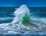
Powerful waves are a source of fascination when they break along our shores. While surfers seek out the 'perfect' wave, dangerous waves can put your safety at risk if you like being in, on or around the water. They can also cause damage to coastlines and property. So what causes dangerous waves and how can you stay on top of wave conditions?
Types of waves
First let's consider the two main types of waves.
- Sea waves (also known as wind waves or 'chop') are generated by the wind blowing at the time, and in the recent past, near where you're observing. These waves are characterised by having a short wave period (time between the crests of the waves).
- Swell waves have travelled into the area you're observing after being generated by previous winds in other areas. These waves may travel thousands of kilometres from their origin before reaching you, arriving with very different characteristics to when they were generated. There is generally one dominant swell direction, however in some areas two or three different swells may occur.
Some forecasts refer to 'total wave height'. This is the combined height of the sea waves and the swell waves. Remember, there may be swell present even if the wind is calm and there are little or no sea waves.
Read more about wave height and the terms used to describe seas and swell.
Animation: Understanding waves.
What causes dangerous waves?
Wave conditions vary from day to day along the coastline. Some days there may be consistent lines of waves heading towards the shore. On other days, the waves may be more mixed, with waves of different sizes travelling in different directions. What factors are at play?
Wind
Wind is the principal cause of wave development. The size of the waves is determined by three factors:
- wind speed (strength)—the intensity of the wind transferring momentum to the ocean surface;
- duration—the length of time the wind blows; and
- fetch—the distance over which the wind blows.
Generally speaking, the stronger the wind, and the more time and distance the wind has to blow, the larger the swell waves generated. Winds can also cause small 'messy' waves or chop in the immediate area (i.e. sea waves).
Weather systems
Low pressure systems are atmospheric circulations that rotate clockwise in the southern hemisphere. They're generally associated with stronger winds, unsettled conditions, cloudiness, and rainfall. Dangerous waves can be generated by low pressure systems, including those far away. The size of the waves will be influenced by the size, strength, and duration of the weather system.
Examples of some intense low-pressure systems are:
- East Coast Lows—these occur several times each year off the eastern coast of Australia. These storms can produce powerful waves and storm surges. In 2016 record-breaking maximum wave heights up to 17.7 m were observed off the coast of Sydney during an East Coast Low.
- Tropical cyclones—these form over warm tropical waters, typically when the sea surface temperature is above 26.5 °C and other atmospheric conditions are favourable. As well as extreme winds, a tropical cyclone can cause the sea to rise above the highest tide levels when the system comes ashore. These storm surges are caused mainly by strong onshore winds and reduced atmospheric pressure.
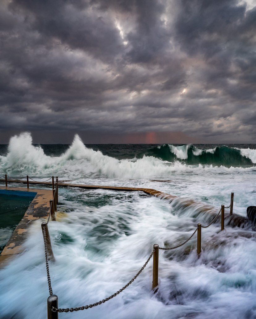
Image: waves at South Curl Curl on Sydney's Northern Beaches. Credit: Lee Stevenson.
Wave sets and wave period
The wave period represents the amount of time between successive wave crests (or troughs) of the most energetic waves. The more time between waves the greater the amount of energy associated with the waves. While they're in deep water, long period swells are not generally a problem, but as they approach shallow water, their speed decreases while their steepness and height increases.
Over time and distance, waves that move at nearly the same speed keep pace with one another and organise to form a group (known as a 'set' of waves). The time between each set varies, as does the number of waves in each set (it can be three to upwards of 15 large waves in a row). Smaller waves are usually in the lead, larger waves in the middle, and smaller waves again towards the end of the set.
Sets of waves can come in every few minutes, or every half hour or more, depending on how far the waves have travelled. Usually the longer the distance they've travelled, the longer the time of the intervening 'lull' between sets.
A long time between sets can give the ocean a deceptively calm appearance before the arrival of the next set of waves. Waves breaking on the beach or overtopping rocks can then take people by surprise.
What other wave conditions are dangerous?
Cross seas
When waves come from different directions that are more than 45 degrees apart, the sea state can be described as a ‘cross sea’. An example situation is when the sea waves are coming from the north, but a large swell is coming from the west or the south. A small vessel operating in cross-sea conditions may experience uncomfortable or unpredictable motion. Mariners sometimes refer to this as a ‘confused sea state’.
Opposing currents
When fast flowing currents oppose the dominant wave direction, the sea state can change. Waves become steeper, and conditions feel rougher. This can happen at the entrance to a large bay or river mouth where tidal currents run out to sea opposing large waves coming onshore. This effect is also created along the East Australian Current.
Rogue waves
Rogue or king waves are very large waves greater than twice the average wave height and should generally be expected to occur three to four times each day at any one place. These waves are caused by complex interactions between multiple waves. Read more about wave height and what you can expect throughout the day.

How do I know if there are dangerous waves about?
You can keep track of wave conditions through warnings, forecasts and observations.
Warnings
The following warnings are available at www.bom.gov.au/australia/warnings (or via the BOM Weather app):
- Hazardous Surf Warning—issued for surf and swell conditions that are hazardous for boaters crossing sand bars, fishing or activities on rock platforms, and swimming. Warnings are issued for unusual wave conditions based on a combination of wave height and period.
- Severe Weather Warning, Damaging Surf/Dangerous Surf—issued for unusually large surf waves that may cause dangerous conditions, including possible damage to property and coastal erosion.
- Severe Weather Warning, Abnormally High Tides—issued for unusual tides (or storm tides) which may affect coastal infrastructure.
Not all wave conditions that could be dangerous to marine activities will trigger a weather warning. For example, small waves and rip currents can also be dangerous for people on paddlecraft or swimming. Warnings are issued for a broad area of the coast and local effects such as coastal orientation, sandbars, and headlands may exacerbate or mitigate local wave conditions.
It is important to note that wave heights provided in forecasts and warnings are averages based on 'significant' wave height (defined as the average height of the highest one third of waves). It's normal to expect waves twice the height shown in the forecast, so if you undertake marine-based activities (such as boating) you need to be prepared for more extreme conditions.
Forecasts
We have dedicated marine forecasts for Australia's coastal waters (the area within roughly 60 nautical miles of the coastline). These describe the seas and swells expected for each forecast area and use internationally recognised marine terminology, expressing wind in knots, and distance in nautical miles. It's also important to remember that wind speed forecasts and observations are based on 10 minute averages; wind gusts will be higher but don't last as long.
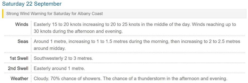
Image: Coastal Waters forecast, including a Strong Wind Warning for Albany Coast
You can also check MetEye for more detailed, map-based forecasts. Select 'Waves Forecasts' and then either Total wave height, Swell1/Swell2 height and direction, or Wind wave height to see the forecast display.
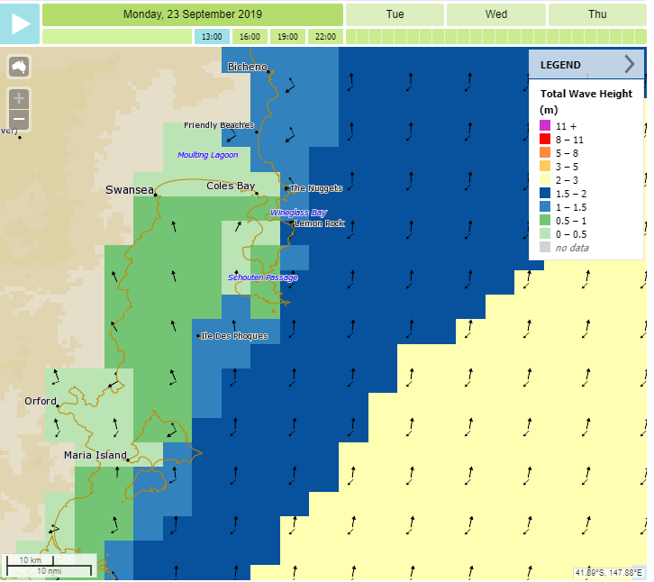
Map: Three-hourly total wave height forecast in MetEye.
Wave period forecasts determined by a numerical model are available.
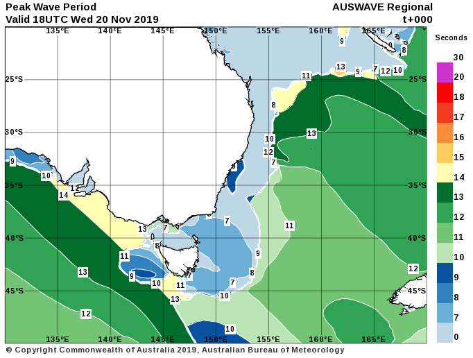
Map: Wave period forecast map.
Real-time wave observations
Wave-recording buoys provide near real-time information about the height and direction of waves. The Bureau has buoys at Cape Sorell, on the west coast of Tasmania, and Cape du Couedic near Kangaroo Island in South Australia. Other organisations operate networks of wave buoys for other locations around Australia.
More information
- Ruling the waves: How a simple wave height concept can help you judge the size of the sea
- Waves from distant storms: a fatal combination for Australia’s rock fishers

Comment. Tell us what you think of this article.
Share. Tell others.