
What is a tropical cyclone?
05 November 2015
Updated 8 October 2018
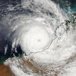
Tropical cyclones are usually defined as low pressure systems that form over warm, tropical waters. This definition makes them sound almost harmless. But as anyone who has experienced a cyclone knows, it's far from the case. They're violent, spiralling wind and rain systems that can wreak havoc at sea and on land. They cause extensive flooding, foreshore erosion, wind damage, and loss of property and life.
How do tropical cyclones form?
Over warm tropical oceans, a cluster of thunderstorms can start rotating around a common centre, due to the earth's rotation. If the conditions are just right, this process can sustain itself and create a tropical cyclone.
At this stage, the tropical cyclone is like a giant, atmospheric heat engine. The moisture from the warm oceans is its fuel, generating huge amounts of energy.
The rotating thunderstorms form spiral rainbands. Their clouds, circling around the circular eye (centre) of the cyclone where the strongest winds are found, transport heat 15 km or higher into the atmosphere. There, drier cooler air becomes the exhaust gas of the heat engine.
Some of this cool air sinks into the low-pressure region at the centre of the cyclone—the relatively calm eye. The eye is usually about 40 km wide but can range from ten to over 100 km, with light winds and often clear skies. The rest of the cool air spirals outward, away from the cyclone centre, sinking in the regions between the rainbands.
As long as the environmental conditions support this atmospheric heat engine, the tropical cyclone can maintain its structure and even intensify.
Widespread, gale force winds
In a tropical cyclone, gale force winds—sustained winds of 63 km/h or more, with gusts over 90 km/h—can extend for hundreds of kilometres, rotating around the eye of the cyclone.
In severe tropical cyclones, winds exceed 118 km/h with gusts over 165 km/h.
Rising seas lead to storm surges
As well as damaging winds, a tropical cyclone can cause the sea to rise well above normal tide levels when it comes ashore. These storm surges are caused by strong, onshore waves or reduced atmospheric pressure—or both. Potentially, they are the most dangerous hazard associated with a tropical cyclone.
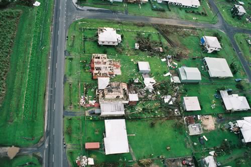
Image: Damage to houses in Innisfail, Queensland, caused by tropical cyclone Larry, March 2006. Credit: Peter Otto
Forming, persisting and weakening
Tropical cyclones can only form when the sea surface temperature is over 26.5 °C. However, once formed, they can persist over lower sea surface temperatures.
They can last for many days, and follow erratic paths. In our region, they can be more erratic than in other parts of the world, moving in any direction, making sharp turns, and even loops.
Tropical cyclones usually weaken over land or colder oceans.
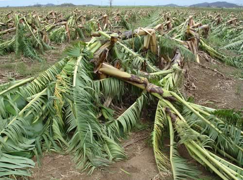
Image: Damaged banana plantation in Innisfail, Queensland, caused by tropical cyclone Larry, March 2006. Credit: Jim Davidson
For more information about tropical cyclones visit our Tropical Cyclone Knowledge Centre. For the latest tropical cyclone warnings and advice visit www.bom.gov.au/cyclone


Comment. Tell us what you think of this article.
Share. Tell others.