Bon voyage: How MetEye wind wave forecast maps can keep you and your boat safe in coastal waters
21 September 2015
The new wind wave and swell forecasts on the Bureau’s MetEye service provide a practical mapping tool for skippers who know their vessels’ capabilities.
Knowing your boat
People in small craft (from kayaks up to runabouts) often consider 15 knots as a key wind threshold when deciding whether it’s safe to head out on the water. The notion that conditions don’t become difficult until the wind reaches 15 knots may work as a basic rule of thumb, but it does not allow for any of the huge number of other variables that contribute to seafaring safety.
Firstly, the prevailing wind needs to blow across a large stretch of water to build up the rough seas that can become dangerous to small boats. If you are near the coast, with the wind blowing from the land, water conditions may be calm even in 15 knot winds; but the further away from shore you travel, the rougher the waves will become. Then when you start to head home into the wind, the waves will also be travelling into the bows of your boat.
Furthermore, different designs and sizes of boats respond very differently to varying wave conditions and heights. Whilst larger vessels should handle rough water much better than smaller ones, there are many more factors to consider in evaluating how well your boat will handle rough seas. The Australian and New Zealand Safe Boating Education Group and State Marine Safety Agencies recommend that skippers know how their boat behaves, and its limitations, before heading out into open water.
Understanding waves and swell
Wind waves (or seas) are the closely spaced waves that make for choppy boating conditions, whilst swell waves have a longer distance between each wave.
Wind waves of half a metre are known to swamp smaller vessels, and because of this State Marine Safety Agencies recommend skippers slow their speed to minimise crew discomfort.
The Australian and New Zealand Safe Boating Education Group advises skippers—and particularly the buyers of new boats—to know the general wind and wave conditions of their boating area, as well as the capabilities and limitations of their individual vessel, before heading out on the water.
MetEye to the rescue
In September 2015, MetEye, the interactive map-based weather viewer on the Bureau’s website, was upgraded to provide a far more comprehensive wave forecasting service for Australia’s coastal waters.
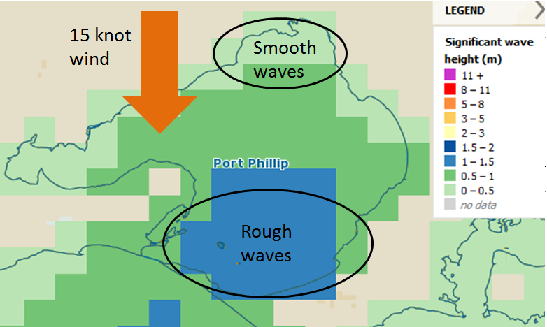
As shown below, the wind wave height map can clearly indicate which areas of water are sheltered by land masses that reduce the wave height.

Wind wave height map of Port Phillip Bay, Victoria
This is useful for kayak and canoe users, who can use the maps to identify days or areas where the wind wave height will generally average less than 0.5 metres. Fishing charter operators, meanwhile, can use the wind wave and swell maps to help clients pick the best ‘weather windows’ in which to head out on the water.
Recreational boaters are encouraged to use these improved MetEye functions as part of their 'five vital weather checks' before heading out on the water.
As conditions can change rapidly, skippers are also advised to continue monitoring the weather via www.bom.gov.au and VHF weather broadcasts at regular intervals during their trip.
More information
MetEye: www.bom.gov.au/australia/meteye
Marine and ocean services: www.bom.gov.au/marine
Important note:
Please be aware that maximum wave heights may be up to twice the significant wave heights presented on MetEye. This applies to the Total wave height, Swell1, Swell2, and Wind Wave Height maps.


Comment. Tell us what you think of this article.
Share. Tell others.