
What causes a tropical low to become a cyclone?
18 October 2019
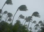
Eleven tropical cyclones form (on average) in the warm tropical waters around northern Australia each year. They bring with them extraordinary weather, including gale-force winds and heavy rainfall, and can cause serious destruction and devastation. So, how and where do they begin and what's needed for one to 'spin up'?
Tropical cyclones have humble beginnings, as weaker circulations known as 'tropical lows' (low pressure systems). Despite having lower wind speeds than cyclones, tropical lows can still pack a punch, bringing powerful thunderstorms and lots of rain.
The storms of a tropical low or cyclone can be seen on satellite imagery. They can range in shape from an indistinct blob to a classic 'spiral-band' pattern. Their appearance gives an indication of their wind strength. When the winds around the centre reach gale force (63 km/h or greater) the tropical low has grown into a cyclone, and is named.
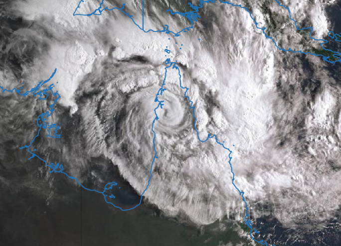
Image: Tropical cyclone Trevor over the Cape York Peninsula showing a spiral-band pattern, 20 March 2019. Credit: Image from Japan Meteorological Agency's Himawari satellite.
Each cyclone season (officially November–April), our forecasters closely monitor tropical lows. Only some will become fully fledged tropical cyclones. So, what causes some to grow and develop, and others to peter out?
Brewing up a storm
In nature, the making of a cyclone is a bit like the baking of a cake—all the ingredients need to come together in the right way.
Location, location, location: where do cyclones form?
To have a good chance of developing, a tropical low needs to be far enough away from the equator, (usually at least 500 km), so that the Coriolis effect can support its 'spin up'.
It is possible for a cyclone to form on or near the equator, if there is enough rotation from the wind. However, such systems are rare and tend to be short-lived.
A cyclone also needs warm sea surface temperatures (at least 26.5 °C), to help maintain its warm core. The warm waters provide fuel for the tropical low to grow. This differentiates tropical lows and cyclones from low pressure systems in mid-latitude regions (including east coast lows). Unlike their tropical cousins, those systems have a cold core and are fuelled by temperature gradients rather than heat.
The tropical waters to the north of Australia are abundantly warm. They are also far enough away from the equator. If this was all it took, we'd potentially see tropical cyclones nearly all year round. So, what else do they need?
A sticky situation: storms and humidity
They need thunderstorms—and lots of them! These must be persistent, with stormy weather continuing day and night—think of a washing machine that doesn't stop. More and more moisture is needed to help feed the thunderstorm clouds. Much of this is supplied by the warm ocean waters below, but the storms also need a moist atmosphere (high humidity). If the atmosphere is too dry, the thunderstorms won't be sustained and a tropical low can't develop further.
New thunderstorms must keep rising, replacing older ones. For this to happen, the atmosphere needs to be highly unstable. Instability occurs when the air lower and nearer the surface is less dense and therefore more buoyant than the air above it. Hot air rises, and in a very humid atmosphere, as the air rises it is continually replaced by more hot humid air. This maintains the instability and helps provide the fuel needed to support thunderstorm growth and organisation.
But how do the thunderstorms become more organised—more cohesive and unified in their arrangement? And how does that relate to the winds increasing and strengthening?
Driving the engine: sustaining the cyclone
You can think of a cyclone as a strong and well-established engine. Hot and humid air spirals into the centre. Then it rises on a grand scale through the thunderstorms. Once that air reaches the top of the thunderstorms, it flows outward. For the engine to keep running it needs fuel—in this case a continuous supply of warm moist air. This can come from evaporation from the sea, or be fed in at low levels by the wind. The thunderstorms initially help to draw in the air. As the air nears the centre, it spins faster and the winds become stronger, drawing in air more quickly. So the thunderstorms and the inflowing air reinforce each other, supporting the overall structure of the cyclone.
Animation: How tropical cyclones form
To get to that stage, the tropical low needs wind conditions that will allow it to take on a better defined and more effective shape. At the surface, the winds need to circulate and come together. This allows warm moist air to be drawn in to the structure. Meanwhile, throughout the depth of the atmosphere, the differences in the wind strength and direction with height (called the vertical wind shear) need to be relatively small. This is important because if the winds are too strong, and/or moving in different directions too much—playing tug of war—they could pull the structure apart. A favourable atmospheric environment will enable the thunderstorms to grow tall and strong.
If all these key ingredients are found, there is a good chance of the tropical low intensifying into a cyclone.
An extra kick: what else helps cyclones develop?
Other factors that can assist tropical low/cyclone development, such as:
- being embedded within a monsoon trough, or other favourable broadscale environmental winds;
- spending a longer time over water—the tropical low/cyclone takes time to intensify, and it weakens when it moves over land; and
- climate drivers, such as tropical waves. The most significant of these is the Madden–Julian Oscillation (MJO). A positive signal from the MJO can give a big boost.
Forecasting cyclones
Cyclones can follow quite erratic paths, but it's possible to forecast where they will go and how quickly. The key is understanding the flow of the winds in the surrounding environment. These winds guide the speed and direction of the overall movement of the cyclone. If the right ingredients remain then the cyclone may continue to strengthen as it moves. On the other hand, if the cyclone moves into an environment that is less favourable, such as over land or cooler waters, or it encounters strong vertical wind shear, it may weaken.
Forecasting cyclone movement is complicated for many reasons. The weather model doesn't always capture the situation accurately. The cyclone can be influenced by land interactions and other smaller-scale factors which may be unknown. Cyclones remain a fascinating area for research.
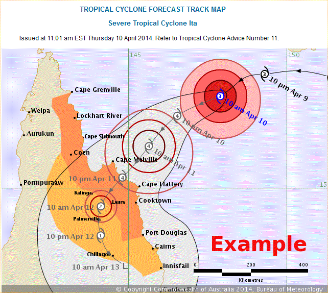
We issue cyclone track maps (see example below), where the expected range of possibilities about the path of the cyclone's centre is shown by the grey area around the most likely track. It is important to be aware that the effects of the cyclone can still be felt outside of the grey zone, particularly if the cyclone's centre approaches its edge.
If there is a chance that a tropical cyclone may be headed your way, it is important to prepare ahead of time and follow the latest warnings and advice.
More information
Tropical cyclone knowledge centre
How do tropical cyclones get their names?


Comment. Tell us what you think of this article.
Share. Tell others.